Fond du Lac County is a county in the U.S. state of Wisconsin. As of the 2010 census, the population was 101,633. Its county seat is Fond du Lac. The county was created in the Wisconsin Territory in 1836 and later organized in 1844. Fond du Lac is French for "bottom of the lake", so given because of the county's location at the southern shore of Lake Winnebago. Fond du Lac County comprises the Fond du Lac, Wisconsin Metropolitan Statistical Area. The Holyland region is in northeastern Fond du Lac County.

Calumet County is a county located in the U.S. state of Wisconsin. As of the 2010 census, the population was 48,971. The county seat is Chilton. The county was created in 1836 and organized in 1850.
Charlestown is a town in Calumet County in the U.S. state of Wisconsin. The population was 775 at the 2010 census. The unincorporated community of Hayton is located in the town.

Woodville is a town in Calumet County in the U.S. state of Wisconsin. The population was 980 at the 2010 census. The unincorporated communities of Dundas and St. John are located in the community.
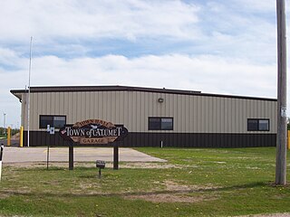
Calumet is a town in Fond du Lac County, Wisconsin, United States. The population was 1,514 at the 2000 census. The unincorporated communities of Artesia Beach, Calumet Harbor, Garnet, Highland Park, Johnsburg, Laudolff Beach, Marytown, Pipe, Pukwana Beach, Winnebago Heights, and Winnebago Park are located within the town. The unincorporated community of Calumetville is located partially in the town.

Hortonville is a village in Outagamie County, Wisconsin, United States. The population was 2,711 at the 2010 census.

Chilton is a town in Calumet County in the U.S. state of Wisconsin. The population was 1,143 at the 2010 census. The City of Chilton is located partially within the town. The unincorporated community of Brant is located in the town.

Genesee Depot is a small unincorporated community in Waukesha County, Wisconsin, United States. It is in the Town of Genesee, in southeastern Wisconsin between Milwaukee and Madison, and named for the train station, or depot, of the Wisconsin and Calumet Railroad that formerly served the town. Wisconsin State Highways 59 and 83 intersect in Genesee Depot.

Pipe, Wisconsin is an unincorporated community in the Town of Calumet in Fond du Lac County, Wisconsin, United States. It is located approximately 1 mile (1.6 km) east of Lake Winnebago.

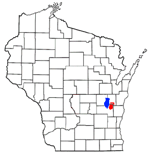
Johnsburg, Wisconsin is an unincorporated community in the Town of Calumet in Fond du Lac County, Wisconsin. The community is located on County Roads Q and W, approximately 3.3 miles (5.3 km) east of Lake Winnebago, 2.75 miles (4.43 km) southeast of Pipe and 1.4 miles (2.3 km) northwest of Malone. Johnsburg is part of the Holyland region in northeastern Fond du Lac county.

Calumetville is an unincorporated community that straddles the county line between Calumet and Fond du Lac counties in Wisconsin. The main part of the community in Fond du Lac County lies in the town of Calumet, and the part in Calumet County lies in the town of Brothertown.

St. Anna is an unincorporated community in Calumet and Sheboygan Counties in the U.S. state of Wisconsin. It lies in the towns of Russell and New Holstein.

Garnet is an unincorporated community in Mackinac County in the U.S. state of Michigan. The community is located within Hudson Township. As an unincorporated community, Garnet has no legally defined boundaries or population statistics of its own.
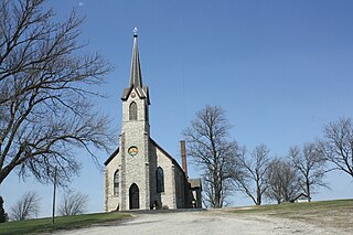
The Holyland is an American region located mainly in northeastern Fond du Lac County, Wisconsin and southern Calumet County. The area is known for its distinctive agricultural landscape, a close-knit community life, and deep Roman Catholicism brought by Germans who first settled the region in the 1840s. The area has been studied as an example of chain migration. It has been called "The Holyland" since at least 1898.
Tremont, Indiana, is a ghost town formerly located in what is now the Indiana Dunes State Park and Indiana Dunes National Park in Westchester Township in northern Porter County, Indiana. It was first established in 1833. It was located at the intersection of U.S. Highway 12 and County Road 100 East, near Indiana 49. The community is named for three massive sand dunes that are now contained within the State park. They are Mount Tom, Mount Holden 170 feet (52 m), and Mount Green 160 feet (49 m).

Charlesburg is an unincorporated community in the town of Brothertown in Calumet County, Wisconsin, United States.

Jericho is an unincorporated community in the town of Brothertown in Calumet County, Wisconsin, United States. Jericho is located at the intersection of County highways C & H. Jericho is part of the Holyland region in Wisconsin.

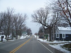
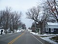
Hayton is an unincorporated community in the town of Charlestown, Calumet County, Wisconsin, United States. It is located a few miles (kilometers) east of Chilton at the intersection of U.S. Route 151 and County T.

Dundas is an unincorporated community located in the town of Woodville, Calumet County, Wisconsin, United States.

Wells is an unincorporated community in the town of Rantoul, Calumet County and the town of Rockland, Manitowoc County, Wisconsin, United States.