Athalia, Ohio

Last updated

Athalia, Ohio
Market north of Myrtle, Athalia.jpg
Houses on Market Street
OHMap-doton-Athalia.png
Location of Athalia, Ohio
Map of Lawrence County Ohio Highlighting Athalia Village.png
Location of Athalia in Lawrence County
Coordinates: 38°30′46″N82°18′34″W / 38.51278°N 82.30944°W / 38.51278; -82.30944
Country United States
State Ohio
County Lawrence
Township Rome
Area
[1]
  Total0.69 sq mi (1.78 km2)
  Land0.69 sq mi (1.78 km2)
  Water0.00 sq mi (0.00 km2)
Elevation
[2]
558 ft (170 m)
Population
 (2020)
  Total279
  Estimate 
(2023) [3]
269
  Density406.71/sq mi (157.12/km2)
Time zone UTC-5 (Eastern (EST))
  Summer (DST) UTC-4 (EDT)
FIPS code 39-02722 [4]
GNIS feature ID2398003 [2]

Athalia is a village in Lawrence County, Ohio, United States, along the Ohio River. The population was 279 at the 2020 census.

Contents

Athalia is a part of the Huntington-Ashland, WV-KY-OH, Metropolitan Statistical Area (MSA).

According to tradition, Athalia was named after the daughter of a first settler. [5]

Geography

According to the United States Census Bureau, the village has a total area of 0.69 square miles (1.79 km2), all land. [6]

Demographics

Historical population
CensusPop.Note
1880 251
1890 199−20.7%
1900 34673.9%
1910 226−34.7%
1920 2333.1%
1930 205−12.0%
1940 26328.3%
1950 30716.7%
1960 34111.1%
1970 287−15.8%
1980 36727.9%
1990 346−5.7%
2000 328−5.2%
2010 37313.7%
2020 279−25.2%
2023 (est.)269 [3] −3.6%
U.S. Decennial Census [7]

2010 census

As of the census [8] of 2010, there were 373 people, 152 households, and 101 families living in the village. The population density was 540.6 inhabitants per square mile (208.7/km2). There were 163 housing units at an average density of 236.2 per square mile (91.2/km2). The racial makeup of the village was 97.9% White, 0.8% African American, 0.8% Native American, 0.3% Asian, and 0.3% from two or more races. Hispanic or Latino of any race were 2.1% of the population.

There were 152 households, of which 28.9% had children under the age of 18 living with them, 47.4% were married couples living together, 11.2% had a female householder with no husband present, 7.9% had a male householder with no wife present, and 33.6% were non-families. 28.3% of all households were made up of individuals, and 9.2% had someone living alone who was 65 years of age or older. The average household size was 2.45 and the average family size was 2.98.

The median age in the village was 39.7 years. 21.4% of residents were under the age of 18; 7.6% were between the ages of 18 and 24; 28.9% were from 25 to 44; 29.4% were from 45 to 64; and 12.6% were 65 years of age or older. The gender makeup of the village was 47.7% male and 52.3% female.

2000 census

As of the census [4] of 2000, there were 328 people, 139 households, and 94 families living in the village. The population density was 476.7 inhabitants per square mile (184.1/km2). There were 158 housing units at an average density of 229.6 per square mile (88.6/km2). The racial makeup of the village was 98.17% White, 0.61% African American, 0.61% Native American, 0.30% Asian, and 0.30% from two or more races. Hispanic or Latino of any race were 0.30% of the population.

There were 139 households, out of which 30.2% had children under the age of 18 living with them, 50.4% were married couples living together, 15.8% had a female householder with no husband present, and 31.7% were non-families. 25.9% of all households were made up of individuals, and 13.7% had someone living alone who was 65 years of age or older. The average household size was 2.36 and the average family size was 2.81.

In the village, the population was spread out, with 21.3% under the age of 18, 11.6% from 18 to 24, 30.8% from 25 to 44, 23.5% from 45 to 64, and 12.8% who were 65 years of age or older. The median age was 36 years. For every 100 females, there were 94.1 males. For every 100 females age 18 and over, there were 95.5 males.

The median income for a household in the village was $25,000, and the median income for a family was $30,000. Males had a median income of $29,167 versus $18,542 for females. The per capita income for the village was $12,770. About 7.6% of families and 12.9% of the population were below the poverty line, including 13.7% of those under age 18 and 9.8% of those age 65 or over.

See also

Related Research Articles

<span class="mw-page-title-main">Warsaw, Ohio</span> Village in Ohio, United States

Warsaw is a village in Coshocton County, Ohio, United States, along the Walhonding River. The population was 624 at the 2020 census.

<span class="mw-page-title-main">Castine, Ohio</span> Village in Ohio, United States

Castine is a village in Darke County, Ohio, United States. The population was 110 at the 2020 census.

<span class="mw-page-title-main">Brice, Ohio</span> Village in Ohio, United States

Brice is a village in Franklin County, Ohio, United States, on the southeast side of the Columbus metropolitan area. The population was 93 at the 2020 census.

<span class="mw-page-title-main">Addyston, Ohio</span> Village in Ohio, United States

Addyston is a village in Miami Township, Hamilton County, Ohio, United States. Located along the Ohio River, it is a western suburb of the neighboring city of Cincinnati. The population was 927 at the 2020 census.

<span class="mw-page-title-main">Cleves, Ohio</span> City in Ohio, United States

Cleves is a village in Miami Township, Hamilton County, Ohio, United States. Located along the Ohio River, it is a western suburb of Cincinnati. The population was 3,414 at the 2020 census.

<span class="mw-page-title-main">Elmwood Place, Ohio</span> Village in Hamilton County, Ohio, United States

Elmwood Place is a village in Hamilton County, Ohio, United States. The population was 2,087 at the 2020 census. Except for a small portion which touches neighboring St. Bernard, Elmwood Place is nearly surrounded by the city of Cincinnati.

<span class="mw-page-title-main">Evendale, Ohio</span> Village in Ohio, United States

Evendale is a village in Hamilton County, Ohio, United States, within the Cincinnati metropolitan area. The population was 2,669 at the 2020 census.

<span class="mw-page-title-main">Woodlawn, Ohio</span> Village in Ohio, United States

Woodlawn is a village in Hamilton County, Ohio, United States. The population was 3,916 at the 2020 census.

<span class="mw-page-title-main">Mowrystown, Ohio</span> Village in Ohio, United States

Mowrystown is a village in Highland County, Ohio, United States. The population was 385 at the 2020 census.

<span class="mw-page-title-main">Proctorville, Ohio</span> Village in Ohio, United States

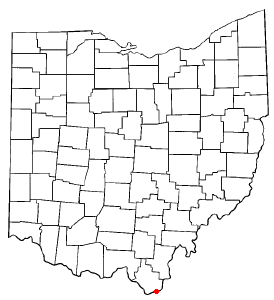
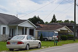
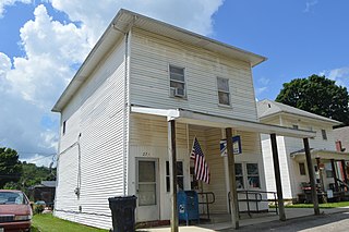
Proctorville is a village in Lawrence County, Ohio, United States, along the Ohio River. The population was 523 at the 2020 census. The East End Bridge connects Proctorville to Huntington, West Virginia across the Ohio River.

<span class="mw-page-title-main">Hebron, Ohio</span> Village in Ohio, USA

Hebron is a village in Licking County, Ohio, United States. The population was 2,326 at the 2020 census.

<span class="mw-page-title-main">St. Louisville, Ohio</span> Village in Ohio, United States

St. Louisville or Saint Louisville is a village in Licking County, Ohio, United States, along the North Fork of the Licking River. The population was 352 at the 2020 census.

<span class="mw-page-title-main">Montezuma, Ohio</span> Village in Ohio, United States

Montezuma is a village in Mercer County, Ohio, United States. The population was 152 at the 2020 census.

<span class="mw-page-title-main">Cloverdale, Ohio</span> Village in Ohio, United States

Cloverdale is a village in Perry Township, Putnam County, Ohio, United States. The population was 170 at the 2020 census.

<span class="mw-page-title-main">Limaville, Ohio</span> Census-designated place in Ohio, United States

Limaville is a census-designated place (CDP) and former village in Stark County, Ohio, United States. The population was 151 at the 2020 census. It is part of the Canton–Massillon Metropolitan Statistical Area.

<span class="mw-page-title-main">Clinton, Ohio</span> Village in Ohio, United States

Clinton is a village in southwestern Summit County, Ohio, United States. The population was 1,197 at the 2020 Census. It is part of the Akron metropolitan area.

<span class="mw-page-title-main">Port Washington, Ohio</span> Village in Ohio, United States

Port Washington is a village in Tuscarawas County, Ohio, United States. The population was 548 at the 2020 census.

<span class="mw-page-title-main">Macksburg, Ohio</span> Village in Ohio, United States

Macksburg is a village in Washington County, Ohio, United States, along the West Fork of Duck Creek. The population was 120 at the 2020 census. The village is about 28 miles (45 km) south of Cambridge, Ohio.

<span class="mw-page-title-main">Wilson, Ohio</span> Village in Ohio, United States

Wilson is a village in Belmont and Monroe counties in the U.S. state of Ohio. The population was 129 at the 2020 census. It is part of the Wheeling metropolitan area.

<span class="mw-page-title-main">Gratiot, Ohio</span> Village in Ohio, United States

Gratiot is a village in Licking and Muskingum counties in the U.S. state of Ohio. The population was 215 at the 2020 census.

References

  1. "ArcGIS REST Services Directory". United States Census Bureau. Retrieved September 20, 2022.
  2. 1 2 U.S. Geological Survey Geographic Names Information System: Athalia, Ohio
  3. 1 2 "Annual Estimates of the Resident Population for Incorporated Places in Ohio: April 1, 2020 to July 1, 2023". United States Census Bureau. Retrieved May 21, 2024.
  4. 1 2 "U.S. Census website". United States Census Bureau . Retrieved January 31, 2008.
  5. Overman, William Daniel (1958). Ohio Town Names. Akron, OH: Atlantic Press. p. 6.
  6. "US Gazetteer files 2010". United States Census Bureau. Archived from the original on January 25, 2012. Retrieved January 6, 2013.
  7. "Census of Population and Housing". Census.gov. Retrieved June 4, 2015.
  8. "U.S. Census website". United States Census Bureau . Retrieved January 6, 2013.