Attica, Ohio

Last updated

Attica, Ohio
Attica, Ohio as viewed from Main Street.JPG
Downtown viewed from South Main Street, looking toward the intersection of Ohio 4 and U.S. 224
Map of Seneca County Ohio Highlighting Attica Village.png
Location of Attica in Seneca County
USA Ohio relief location map.svg
Red pog.svg
Attica
Usa edcp relief location map.png
Red pog.svg
Attica
Coordinates: 41°03′49″N82°53′14″W / 41.06361°N 82.88722°W / 41.06361; -82.88722
Country United States
State Ohio
County Seneca
Founded1833
Government
  Type Village council
Area
[1]
  Total0.68 sq mi (1.75 km2)
  Land0.67 sq mi (1.73 km2)
  Water0.01 sq mi (0.02 km2)
Elevation
[2]
948 ft (289 m)
Population
 (2020)
  Total873
  Estimate 
(2023) [3]
868
  Density1,308.85/sq mi (505.41/km2)
Time zone UTC-5 (Eastern (EST))
  Summer (DST) UTC-4 (EDT)
ZIP code
44807
Area code 419
FIPS code 39-02820 [4]
GNIS feature ID2398006 [2]
Website http://www.atticaohio.us/

Attica is a village in Seneca County, Ohio, United States. The population was 873 at the 2020 census.

Contents

Attica was designated a Tree City USA by the National Arbor Day Foundation.

History

Attica was named after Attica, New York, the hometown of a pioneer settler. [5] [6]

One of the first women to die in World War I, Clara Ayres, is buried in the local cemetery. An Ohio Historical Marker has been placed in the cemetery to commemorate her. [7]

Geography

Aerial photo of Attica, 2012 Attica, Ohio (7981723694).jpg
Aerial photo of Attica, 2012

According to the United States Census Bureau, the village has a total area of 0.67 square miles (1.74 km2), of which 0.66 square miles (1.71 km2) is land and 0.01 square miles (0.03 km2) is water. [8]

Demographics

Historical population
CensusPop.Note
1840 100
1870 370
1880 66379.2%
1890 6822.9%
1900 6941.8%
1910 7193.6%
1920 658−8.5%
1930 78319.0%
1940 780−0.4%
1950 85810.0%
1960 96512.5%
1970 1,0054.1%
1980 865−13.9%
1990 9449.1%
2000 9551.2%
2010 899−5.9%
2020 873−2.9%
2023 (est.)868 [3] −0.6%
U.S. Decennial Census [9]

2010 census

As of the census [10] of 2010, there were 899 people, 364 households, and 266 families living in the village. The population density was 1,362.1 inhabitants per square mile (525.9/km2). There were 428 housing units at an average density of 648.5 per square mile (250.4/km2). The racial makeup of the village was 96.3% White, 0.8% African American, 0.2% from other races, and 2.7% from two or more races. Hispanic or Latino of any race were 1.3% of the population.

There were 364 households, of which 33.8% had children under the age of 18 living with them, 54.9% were married couples living together, 15.1% had a female householder with no husband present, 3.0% had a male householder with no wife present, and 26.9% were non-families. 25.0% of all households were made up of individuals, and 12.1% had someone living alone who was 65 years of age or older. The average household size was 2.47 and the average family size was 2.88.

The median age in the village was 39.8 years. 25.6% of residents were under the age of 18; 7.8% were between the ages of 18 and 24; 22% were from 25 to 44; 27.1% were from 45 to 64; and 17.5% were 65 years of age or older. The gender makeup of the village was 48.8% male and 51.2% female.

2000 census

As of the census [4] of 2000, there were 955 people, 393 households, and 277 families living in the village. The population density was 1,783.4 inhabitants per square mile (688.6/km2). There were 430 housing units at an average density of 803.0 per square mile (310.0/km2). The racial makeup of the village was 98.95% White, 0.21% Native American, 0.10% from other races, and 0.73% from two or more races. Hispanic or Latino of any race were 0.42% of the population.

There were 393 households, out of which 29.3% had children under the age of 18 living with them, 57.8% were married couples living together, 10.2% had a female householder with no husband present, and 29.5% were non-families. 25.4% of all households were made up of individuals, and 10.9% had someone living alone who was 65 years of age or older. The average household size was 2.43 and the average family size was 2.91.

In the village, the population was spread out, with 23.8% under the age of 18, 9.1% from 18 to 24, 27.0% from 25 to 44, 23.8% from 45 to 64, and 16.3% who were 65 years of age or older. The median age was 38 years. For every 100 females there were 89.5 males. For every 100 females age 18 and over, there were 91.6 males.

The median income for a household in the village was $38,529, and the median income for a family was $44,408. Males had a median income of $37,833 versus $22,969 for females. The per capita income for the village was $17,942. About 8.6% of families and 9.8% of the population were below the poverty line, including 9.4% of those under age 18 and 6.3% of those age 65 or over.

Education

Attica is in the Seneca East Local School District, which includes Seneca East High School. [11] Until consolidation with Republic into Seneca East, the village was served by the Attica School District.[ citation needed ]

Related Research Articles

<span class="mw-page-title-main">Attica, Kansas</span> City in Harper County, Kansas

Attica is a city in Harper County, Kansas, United States. As of the 2020 census, the population of the city was 516. The town was named after the historical region of Attica, in Greece.

<span class="mw-page-title-main">Seneca, Kansas</span> City in Nemaha County, Kansas

Seneca is a city in and the county seat of Nemaha County, Kansas, United States. As of the 2020 census, the population of the city was 2,139.

<span class="mw-page-title-main">Attica, New York</span> Town in New York, United States

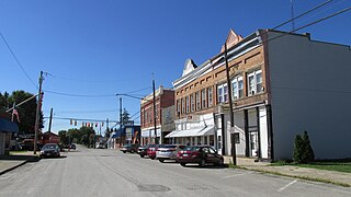
Attica is a town in Wyoming County, New York, United States. The population was 7,702 as of 2010.

<span class="mw-page-title-main">Aberdeen, Ohio</span> Village in Ohio, United States

Aberdeen is a village in Huntington Township, Brown County, Ohio, United States, along the Ohio River 50 miles (80 km) southeast of Cincinnati. The population was 1,515 at the 2020 census.

<span class="mw-page-title-main">Brice, Ohio</span> Village in Ohio, United States

Brice is a village in Franklin County, Ohio, United States, on the southeast side of the Columbus metropolitan area. The population was 93 at the 2020 census.

<span class="mw-page-title-main">Senecaville, Ohio</span> Village in Ohio, United States

Senecaville is a village in Guernsey County, Ohio, United States. The population was 422 at the 2020 census.

<span class="mw-page-title-main">Addyston, Ohio</span> Village in Ohio, United States

Addyston is a village in Miami Township, Hamilton County, Ohio, United States. Located along the Ohio River, it is a western suburb of the neighboring city of Cincinnati. The population was 927 at the 2020 census.

<span class="mw-page-title-main">Cleves, Ohio</span> City in Ohio, United States

Cleves is a village in Miami Township, Hamilton County, Ohio, United States. Located along the Ohio River, it is a western suburb of Cincinnati. The population was 3,414 at the 2020 census.

<span class="mw-page-title-main">Elmwood Place, Ohio</span> Village in Hamilton County, Ohio, United States

Elmwood Place is a village in Hamilton County, Ohio, United States. The population was 2,087 at the 2020 census. Except for a small portion which touches neighboring St. Bernard, Elmwood Place is nearly surrounded by the city of Cincinnati.

<span class="mw-page-title-main">Hanover, Ohio</span> Village in Ohio, United States

Hanover is a village in Licking County, Ohio, United States. The population was 1,270 at the 2020 census. The village lies along Ohio State Route 16.

<span class="mw-page-title-main">Hebron, Ohio</span> Village in Ohio, USA

Hebron is a village in Licking County, Ohio, United States. The population was 2,326 at the 2020 census.

<span class="mw-page-title-main">Cloverdale, Ohio</span> Village in Ohio, United States

Cloverdale is a village in Perry Township, Putnam County, Ohio, United States. The population was 170 at the 2020 census.

<span class="mw-page-title-main">Bettsville, Ohio</span> Village in Ohio, United States

Bettsville is a village in Seneca County, Ohio, United States. The population was 595 at the 2020 census.

<span class="mw-page-title-main">Bloomville, Ohio</span> Village in Ohio, United States

Bloomville is a village in Seneca County, Ohio, United States. The population was 867 at the 2020 census.

<span class="mw-page-title-main">Republic, Ohio</span> Village in Ohio, United States

Republic is a village in Seneca County, Ohio, United States. The population was 556 at the 2020 census.

<span class="mw-page-title-main">Navarre, Ohio</span> Village in Ohio, United States

Navarre is a village in southwestern Stark County, Ohio, United States. The population was 1,846 at the 2020 census. It is part of the Canton–Massillon metropolitan area.

<span class="mw-page-title-main">Clinton, Ohio</span> Village in Ohio, United States

Clinton is a village in southwestern Summit County, Ohio, United States. The population was 1,197 at the 2020 Census. It is part of the Akron metropolitan area.

<span class="mw-page-title-main">Wilson, Ohio</span> Village in Ohio, United States

Wilson is a village in Belmont and Monroe counties in the U.S. state of Ohio. The population was 129 at the 2020 census. It is part of the Wheeling metropolitan area.

<span class="mw-page-title-main">New Holland, Ohio</span> Village in Ohio, United States

New Holland is a village in Fayette and Pickaway counties in Ohio, United States. The population was 804 at the 2020 census.

<span class="mw-page-title-main">Green Springs, Ohio</span> Village in Ohio, United States

Green Springs is a village in Sandusky and Seneca counties in the U.S. state of Ohio. The population was 1,233 at the 2020 census.

References

  1. "ArcGIS REST Services Directory". United States Census Bureau. Retrieved September 20, 2022.
  2. 1 2 U.S. Geological Survey Geographic Names Information System: Attica, Ohio
  3. 1 2 "Annual Estimates of the Resident Population for Incorporated Places in Ohio: April 1, 2020 to July 1, 2023". United States Census Bureau. Retrieved May 21, 2024.
  4. 1 2 "U.S. Census website". United States Census Bureau . Retrieved January 31, 2008.
  5. Butterfield, Consul Willshire (1848). History of Seneca County: Containing a Detailed Narrative of the Principal Events that Have Occurred Since Its First Settlement Down to the Present Time. D. Campbell. pp.  140.
  6. Overman, William Daniel (1958). Ohio Town Names. Akron, OH: Atlantic Press. p. 7.
  7. "A Nurse's Sacrifice in the Great War Historical Marker". www.hmdb.org. Retrieved March 3, 2024.
  8. "US Gazetteer files 2010". United States Census Bureau. Archived from the original on January 25, 2012. Retrieved January 6, 2013.
  9. "Census of Population and Housing". Census.gov. Retrieved June 4, 2016.
  10. "U.S. Census website". United States Census Bureau . Retrieved January 6, 2013.
  11. District website Archived January 10, 2006, at the Wayback Machine