Bloomville, Ohio

Last updated

Bloomville, Ohio
Bloomville, Marion south of New Haven.jpg
OHMap-doton-Bloomville.png
Location of Bloomville, Ohio
Map of Seneca County Ohio Highlighting Bloomville Village.png
Location of Bloomville in Seneca County
Coordinates: 41°03′05″N83°00′49″W / 41.05139°N 83.01361°W / 41.05139; -83.01361
Country United States
State Ohio
County Seneca
Government
  Type Village council
Area
[1]
  Total0.60 sq mi (1.56 km2)
  Land0.60 sq mi (1.56 km2)
  Water0.00 sq mi (0.00 km2)
Elevation
[2]
915 ft (279 m)
Population
 (2020)
  Total867
  Density1,437.81/sq mi (554.75/km2)
Time zone UTC-5 (Eastern (EST))
  Summer (DST) UTC-4 (EDT)
ZIP code
44818
Area code 419
FIPS code 39-07286 [3]
GNIS feature ID2398141 [2]

Bloomville is a village in Seneca County, Ohio, United States. The population was 867 at the 2020 census.

Contents

History

The first settlement at Bloomville was made in 1822. [4] Bloomville was laid out in 1837. [5] It was incorporated as a village in 1871. [6] On November 5, 1889, the village suffered from a major fire. [7]

Geography

According to the United States Census Bureau, the village has a total area of 0.60 square miles (1.55 km2), all land. [8]

Demographics

Historical population
CensusPop.Note
1880 689
1890 75810.0%
1900 8198.0%
1910 754−7.9%
1920 645−14.5%
1930 7008.5%
1940 7507.1%
1950 7591.2%
1960 83610.1%
1970 8845.7%
1980 1,01915.3%
1990 949−6.9%
2000 1,04510.1%
2010 956−8.5%
2020 867−9.3%
U.S. Decennial Census [9]

2010 census

As of the census [10] of 2010, there were 956 people, 349 households, and 229 families living in the village. The population density was 1,593.3 inhabitants per square mile (615.2/km2). There were 382 housing units at an average density of 636.7 per square mile (245.8/km2). The racial makeup of the village was 97.4% White, 0.2% African American, 0.1% Native American, 0.7% from other races, and 1.6% from two or more races. Hispanic or Latino of any race were 2.1% of the population.

There were 349 households, of which 39.5% had children under the age of 18 living with them, 46.1% were married couples living together, 12.6% had a female householder with no husband present, 6.9% had a male householder with no wife present, and 34.4% were non-families. 29.8% of all households were made up of individuals, and 13.5% had someone living alone who was 65 years of age or older. The average household size was 2.66 and the average family size was 3.29.

The median age in the village was 34.3 years. 29.7% of residents were under the age of 18; 8.4% were between the ages of 18 and 24; 25.3% were from 25 to 44; 22.5% were from 45 to 64; and 14.2% were 65 years of age or older. The gender makeup of the village was 50.5% male and 49.5% female.

2000 census

As of the census [3] of 2000, there were 1,045 people, 366 households, and 281 families living in the village. The population density was 1,720.3 inhabitants per square mile (664.2/km2). There were 390 housing units at an average density of 642.0 per square mile (247.9/km2). The racial makeup of the village was 97.51% White, 0.38% African American, 0.29% Native American, 1.15% from other races, and 0.67% from two or more races. Hispanic or Latino of any race were 3.06% of the population.

There were 366 households, out of which 42.1% had children under the age of 18 living with them, 59.6% were married couples living together, 12.8% had a female householder with no husband present, and 23.2% were non-families. 21.0% of all households were made up of individuals, and 11.5% had someone living alone who was 65 years of age or older. The average household size was 2.78 and the average family size was 3.18.

In the village, the population was spread out, with 31.1% under the age of 18, 9.2% from 18 to 24, 26.3% from 25 to 44, 19.0% from 45 to 64, and 14.4% who were 65 years of age or older. The median age was 32 years. For every 100 females there were 89.0 males. For every 100 females age 18 and over, there were 84.1 males.

The median income for a household in the village was $36,250, and the median income for a family was $39,519. Males had a median income of $30,223 versus $21,902 for females. The per capita income for the village was $13,396. About 5.0% of families and 5.8% of the population were below the poverty line, including 5.5% of those under age 18 and 6.6% of those age 65 or over.

Related Research Articles

<span class="mw-page-title-main">Russellville, Ohio</span> Village in Ohio, United States

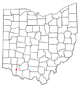
Russellville is a village in Jefferson Township, Brown County, Ohio, United States. The population was 542 at the 2020 census.

<span class="mw-page-title-main">Williamsburg, Ohio</span> Village in Ohio, United States

Williamsburg is a village in Clermont County, Ohio, United States. The population was 2,570 at the 2020 census.

<span class="mw-page-title-main">New Weston, Ohio</span> Village in Ohio, United States

New Weston is a village in Darke County, Ohio, United States. The population was 124 at the 2020 census.

<span class="mw-page-title-main">Senecaville, Ohio</span> Village in Ohio, United States

Senecaville is a village in Guernsey County, Ohio, United States. The population was 422 at the 2020 census.

<span class="mw-page-title-main">Amberley, Ohio</span> Village in Ohio, United States

Amberley, locally known as Amberley Village, is a village in Hamilton County, Ohio, United States. The population was 3,840 at the 2020 census.

<span class="mw-page-title-main">Golf Manor, Ohio</span> Village in Ohio, United States

Golf Manor is a village in Hamilton County, Ohio, United States. It is almost completely surrounded by the Pleasant Ridge and Roselawn neighborhoods of Cincinnati. The population was 3,814 at the 2020 census.

<span class="mw-page-title-main">Woodlawn, Ohio</span> Village in Ohio, United States

Woodlawn is a village in Hamilton County, Ohio, United States. The population was 3,916 at the 2020 census.

<span class="mw-page-title-main">Liberty Center, Ohio</span> Village in Ohio, United States

Liberty Center is a village in Henry County, Ohio, United States. The population was 1,108 at the 2020 census.

<span class="mw-page-title-main">Glenmont, Ohio</span> Village in Ohio, United States

Glenmont is a village in Holmes County, Ohio, United States. The population was 240 at the 2020 census.

<span class="mw-page-title-main">Centerburg, Ohio</span> Village in Ohio, United States

Centerburg is a village in Knox County, Ohio, United States, along the North Fork of the Licking River. As of the 2020 census, the village population was 1,690. Centerburg is located near the geographical center of Ohio.

<span class="mw-page-title-main">Hebron, Ohio</span> Village in Ohio, USA

Hebron is a village in Licking County, Ohio, United States. The population was 2,326 at the 2020 census.

<span class="mw-page-title-main">Beloit, Ohio</span> Village in Ohio, United States

Beloit is a village in southwestern Mahoning County, Ohio, United States. The population was 903 at the 2020 census. It is part of the Youngstown–Warren metropolitan area.

<span class="mw-page-title-main">Syracuse, Ohio</span> Village in Ohio, United States

Syracuse is a village in Meigs County, Ohio, United States, along the Ohio River. The population was 781 at the 2020 census.

<span class="mw-page-title-main">Melrose, Ohio</span> Village in Ohio, United States

Melrose is a village in Paulding County, Ohio, United States. The population was 233 at the 2020 census.

<span class="mw-page-title-main">West Leipsic, Ohio</span> Village in Ohio, United States

West Leipsic is a village in Putnam County, Ohio, United States. The population was 226 at the 2020 census.

<span class="mw-page-title-main">Attica, Ohio</span> Village in Ohio, United States

Attica is a village in Seneca County, Ohio, United States. The population was 873 at the 2020 census.

<span class="mw-page-title-main">Bettsville, Ohio</span> Village in Ohio, United States

Bettsville is a village in Seneca County, Ohio, United States. The population was 595 at the 2020 census.

<span class="mw-page-title-main">Republic, Ohio</span> Village in Ohio, United States

Republic is a village in Seneca County, Ohio, United States. The population was 556 at the 2020 census.

<span class="mw-page-title-main">McDonald, Ohio</span> Village in Ohio, United States

McDonald is a village in southern Trumbull County, Ohio, United States, along the Mahoning River. The population was 3,172 at the 2020 census. It is a suburb of the Youngstown–Warren metropolitan area.

<span class="mw-page-title-main">Bloomdale, Ohio</span> Village in Ohio, United States

Bloomdale is a village in Wood County, Ohio, United States. The population was 665 at the 2020 census.

References

  1. "ArcGIS REST Services Directory". United States Census Bureau. Retrieved September 20, 2022.
  2. 1 2 U.S. Geological Survey Geographic Names Information System: Bloomville, Ohio
  3. 1 2 "U.S. Census website". United States Census Bureau . Retrieved January 31, 2008.
  4. Overman, William Daniel (1958). Ohio Town Names. Akron, OH: Atlantic Press. p. 16.
  5. Butterfield, Consul Willshire (1848). History of Seneca County: Containing a Detailed Narrative of the Principal Events that Have Occurred Since Its First Settlement Down to the Present Time. D. Campbell. pp.  125.
  6. Lang, William (1880). History of Seneca County, from the Close of the Revolutionary War to July, 1880. Transcript Printing Company. pp.  496.
  7. "AN OHIO TOWN BURNING". The New York Times. November 6, 1889. Retrieved April 13, 2022.
  8. "US Gazetteer files 2010". United States Census Bureau. Archived from the original on January 25, 2012. Retrieved January 6, 2013.
  9. "Census of Population and Housing". Census.gov. Retrieved June 4, 2015.
  10. "U.S. Census website". United States Census Bureau . Retrieved January 6, 2013.