Related Research Articles

Warren County is a county located in the eastern portion of the U.S. state of Missouri. As of the 2020 census, the population was 35,532. The county is located on the north side of the Missouri River. Its county seat is Warrenton. The county was established on January 5, 1833, and was named for General Joseph Warren, who died in the Battle of Bunker Hill during the American Revolutionary War.

St. Clair County is a county located in the western portion of the U.S. state of Missouri. As of the 2020 census, the population was 9,284. Its county seat is Osceola. The largest city is Appleton City. The county was organized in 1841 and named after General Arthur St. Clair, Governor of the Northwest Territory. St. Clair was also the 9th president of the United States in Congress Assembled. Under his presidency, the Northwest Ordinance and United States Constitution were passed.

Pettis County is a county located in west central U.S. state of Missouri. As of the 2020 census, the population was 42,980. Its county seat is Sedalia. The county was organized on January 24, 1833, and named after former U.S. Representative Spencer Darwin Pettis.

Johnson County is a county located in western portion of the U.S. state of Missouri. As of the 2020 census, the population was 54,013. Its county seat is Warrensburg. The county was formed December 13, 1834 from Lafayette County and named for Vice President Richard Mentor Johnson.

Henry County is a county located in the western portion of the U.S. state of Missouri. As of the 2020 census, the population was 21,946. Its county seat is Clinton. The county was organized December 13, 1834 as Rives County but was renamed in 1841 for Revolutionary War patriot Patrick Henry. The county originally had been named after William Cabell Rives, who was then serving as a U.S. Senator from Virginia. However, Rives lost popularity in Missouri after he joined the Whig Party.

Bates County is a county located in the west central part of the U.S. state of Missouri, two counties south of the Missouri River and is part of the Kansas City metropolitan area. As of the 2020 census, the population was 16,042. Its county seat is Butler. The county was organized in 1841 and named after Frederick Bates, the second Governor of Missouri.

Charlotte Township is one of twenty-four townships in Bates County, Missouri, and is part of the Kansas City metropolitan area within the USA. As of the 2000 census, its population was 367.
Deepwater Township is one of twenty-four townships in Bates County, Missouri, and is part of the Kansas City metropolitan area within the USA. As of the 2000 census, its population was 247.
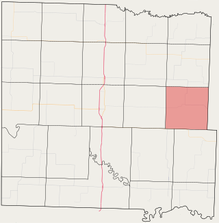
Deer Creek Township is one of twenty-four townships in Bates County, Missouri, and is part of the Kansas City metropolitan area within the USA. As of the 2000 census, its population was 2,162.

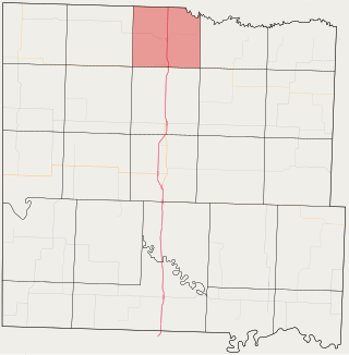
Grand River Township is one of twenty-four townships in Bates County, Missouri, and is part of the Kansas City metropolitan area within the USA. As of the 2000 census, its population was 251.

Lone Oak Township is one of twenty-four townships in Bates County, Missouri, and is part of the Kansas City metropolitan area within the USA. As of the 2000 census, its population was 293.

Mingo Township is one of twenty-four townships in Bates County, Missouri, and is part of the Kansas City metropolitan area within the USA. As of the 2000 census, its population was 235.

New Home Township is one of twenty-four townships in Bates County, Missouri, and is part of the Kansas City metropolitan area within the USA. As of the 2000 census, its population was 222.

Pleasant Gap Township is one of twenty-four townships in Bates County, Missouri, and is part of the Kansas City metropolitan area within the USA. As of the 2000 census, its population was 264.

Prairie Township is one of twenty-four townships in Bates County, Missouri, and is part of the Kansas City metropolitan area within the USA. As of the 2000 census, its population was 153.

Spruce Township is one of twenty-four townships in Bates County, Missouri, and is part of the Kansas City metropolitan area within the USA. As of the 2000 census, its population was 288.
Johnstown is an unincorporated community in northeast Bates County, in the U.S. state of Missouri. The community is on Missouri Route D one half mile west of the Bates-Henry county line. Butler lies 13 miles to the west-southwest. North Deepwater Creek flows past the southwest side of the community.
Sprague is an unincorporated community in southwest Bates County, in the U.S. state of Missouri. The community is five miles west of Rich Hill via Missouri route A and WW. The Harmony Mission Lake Conservation Area lies within one mile to the southeast.
Dayton is an unincorporated community in southeast Cass County, in the U.S. state of Missouri. Garden City is five miles north along Missouri Route F and Creighton lies 6.5 miles east along Missouri Route B. The Settles Ford Conservation Area along the South Grand River lies to the southeast. The community lies atop a ridge between Sugar Creek to the west and Lick Branch to the east. It is part of the Kansas City metropolitan area.
Panama is an unincorporated community in northern Vernon County, in the U.S. state of Missouri. The community is on Missouri Route TT adjacent to the east side of US Route 71. The Vernon-Bates county line is one half mile north. Rich Hill is 3.5 miles north and Nevada is 13 miles south. The Four Rivers Conservation Area on the Little Osage River is two miles south.
References
- ↑ U.S. Geological Survey Geographic Names Information System: Ballard, Missouri
- ↑ Spruce, MO, 7.5 Minute Topographic Quadrangle, USGS, 1962
- ↑ Eaton, David Wolfe (1916). How Missouri Counties, Towns and Streams Were Named. The State Historical Society of Missouri. pp. 285.
- ↑ Atkeson, William Oscar (1918). History of Bates County, Missouri. Brookhaven Press. p. 670.
- ↑ "Home". Ballard R-2 School District. Retrieved September 20, 2020.
Municipalities and communities of Bates County, Missouri, United States | ||
|---|---|---|
| Cities |  | |
| Villages | ||
| Townships | ||
| Unincorporated communities | ||
| Ghost towns | ||
| Footnotes | ‡This populated place also has portions in an adjacent county or counties | |
38°21′41″N94°08′36″W / 38.36139°N 94.14333°W
| | This Bates County, Missouri state location article is a stub. You can help Wikipedia by expanding it. |