Related Research Articles
Deepwater Township is one of twenty-four townships in Bates County, Missouri, and is part of the Kansas City metropolitan area within the USA. As of the 2000 census, its population was 247.

Hudson Township is one of twenty-four townships in Bates County, Missouri, and is part of the Kansas City metropolitan area within the USA. As of the 2000 census, its population was 229. As of the 2010 census, the town's population was 252. Its population was estimated to be 226 in 2018.

Lone Oak Township is one of twenty-four townships in Bates County, Missouri, and is part of the Kansas City metropolitan area within the USA. As of the 2000 census, its population was 293.

New Home Township is one of twenty-four townships in Bates County, Missouri, and is part of the Kansas City metropolitan area within the USA. As of the 2000 census, its population was 222.
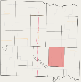
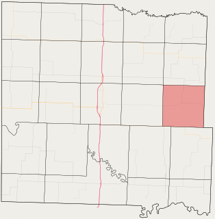
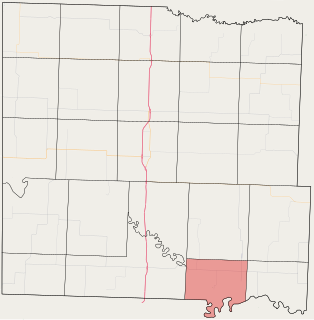
Pleasant Gap Township is one of twenty-four townships in Bates County, Missouri, and is part of the Kansas City metropolitan area within the USA. As of the 2000 census, its population was 264.
Prairie Township is one of twenty-four townships in Bates County, Missouri, and is part of the Kansas City metropolitan area within the USA. As of the 2000 census, its population was 153.
Lead Mountain is a summit in Custer County, Colorado, in the United States. It is in the Wet Mountain Range. With an elevation of 9,731 feet (2,966 m), Lead Mountain is the 2343rd highest summit in the state of Colorado.

Avonburg is an unincorporated community in Pleasant Township, Switzerland County, in the U.S. state of Indiana.
Double Branch is a stream in Bates County in the U.S. state of Missouri. It is a tributary to the Marais des Cygnes River.
Mission Branch is a stream in Bates County in the U.S. state of Missouri. It is a tributary of Sycamore Branch. The stream headwaters are at 38°08′54″N94°12′47″W and the stream flows to the southwest to its confluence with Sycamore Branch at 38°05′16″N94°15′44″W within the floodplain of the Marais des Cygnes River.
Sycamore Branch is a stream in Bates County in the U.S. state of Missouri. It is a tributary of the Marais des Cygnes River. The stream headwaters arise at 38°08′31″N94°14′19″W and the stream flows south-southwest until it reaches the floodplain of the Marais des Cygnes at which point it turns to the southeast for about 1.5 kilometers prior to its confluence at 38°04′37″N94°15′37″W. The source area for the stream is at an elevation of about 875 feet and the confluence is at 738 feet.
Rainy Creek is a stream in Benton and Camden Counties in the U.S. state of Missouri. It is a tributary of the Osage River within the waters of the Lake of the Ozarks.
Wingate is an unincorporated community in northeast Cass County, in the U.S. state of Missouri.
Pleasant Hill Township is an inactive township in Cass County, in the U.S. state of Missouri.
Slaughter Branch is a stream in northern Franklin County in the U.S. state of Missouri. It is a tributary to Brushy Creek.
Mount Pleasant is an unincorporated community in Gentry County, in the U.S. state of Missouri.
Pleasant Ridge is an unincorporated community in Harrison County, in the U.S. state of Missouri.
Deepwater Township is a township in Henry County, in the U.S. state of Missouri.
Pleasant Mount or Mount Pleasant is an unincorporated community in Miller County, in the U.S. state of Missouri. The historic community was located along the current Missouri Route FF on a hilltop approximately one-half mile north of the railroad line. The current community of Mount Pleasant or Mt Pleasant is just south of U.S. Route 54, about three miles northeast of Eldon at 38°22′05″N92°31′25″W.
Turley is an extinct town in Texas County, in the U.S. state of Missouri. The GNIS classifies it as a populated place. The community is located on Roubidoux Creek, approximately two miles downstream (northwest) of Roubidoux. The community of Plato is about 4.5 miles to the northwest.
References
- ↑ U.S. Geological Survey Geographic Names Information System: Pleasant Gap, Missouri
- ↑ Eaton, David Wolfe (1916). How Missouri Counties, Towns and Streams Were Named (in public domain). The State Historical Society of Missouri. p. 208.
- ↑ "Post Offices". Jim Forte Postal History. Retrieved 1 September 2016.
Municipalities and communities of Bates County, Missouri, United States | ||
|---|---|---|
| Cities |  | |
| Villages | ||
| Townships | ||
| Unincorporated communities | ||
| Ghost towns | ||
| Footnotes | ‡This populated place also has portions in an adjacent county or counties | |
Coordinates: 38°10′22″N94°10′56″W / 38.17278°N 94.18222°W
| | This Bates County, Missouri state location article is a stub. You can help Wikipedia by expanding it. |