Related Research Articles
Deepwater Township is one of twenty-four townships in Bates County, Missouri, and is part of the Kansas City metropolitan area within the USA. As of the 2000 census, its population was 247.
Deer Creek Township is one of twenty-four townships in Bates County, Missouri, and is part of the Kansas City metropolitan area within the USA. As of the 2000 census, its population was 2,162.

East Boone Township is one of twenty-four townships in Bates County, Missouri, and is part of the Kansas City metropolitan area within the USA. As of the 2000 census, its population was 482.

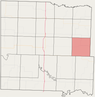
Grand River Township is one of twenty-four townships in Bates County, Missouri, and is part of the Kansas City metropolitan area within the USA. As of the 2000 census, its population was 251.

Lone Oak Township is one of twenty-four townships in Bates County, Missouri, and is part of the Kansas City metropolitan area within the USA. As of the 2000 census, its population was 293.

Mingo Township is one of twenty-four townships in Bates County, Missouri, and is part of the Kansas City metropolitan area within the USA. As of the 2000 census, its population was 235.

New Home Township is one of twenty-four townships in Bates County, Missouri, and is part of the Kansas City metropolitan area within the USA. As of the 2000 census, its population was 222.

Prairie Township is one of twenty-four townships in Bates County, Missouri, and is part of the Kansas City metropolitan area within the USA. As of the 2000 census, its population was 153.

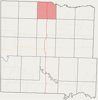
Spruce Township is one of twenty-four townships in Bates County, Missouri, and is part of the Kansas City metropolitan area within the USA. As of the 2000 census, its population was 288.

Papinville is an unincorporated community in southern Bates County, Missouri.
Altona is an unincorporated community in northern Bates County, in the U.S. state of Missouri. The community is on Missouri Route Z just north of Missouri route 18 and approximately 5.5 miles east of Adrian.
Burdett is an unincorporated community in northwest Bates County, in the U.S. state of Missouri. The community is on Missouri Route FF approximately seven miles west northwest of Adrian.
Hudson is an unincorporated community in eastern Bates County, in the U.S. state of Missouri. The community is on a county road just north of Missouri Route 52. The southwest corner of Henry County is one mile to the northeast of the community. Butler is approximately 13 miles to the west-northwest.
Knob Creek is a stream in west central Bates County in the U.S. state of Missouri. It is a tributary of Miami Creek.
Mingo Creek is a stream in Bates County in the U.S. state of Missouri. It is a tributary of the South Grand River.
Sprague is an unincorporated community in southwest Bates County, in the U.S. state of Missouri. The community is five miles west of Rich Hill via Missouri route A and WW. The Harmony Mission Lake Conservation Area lies within one mile to the southeast.
Spruce is an unincorporated community in northeast Bates County, in the U.S. state of Missouri. The community is on Missouri Route H approximately ten miles east of Butler. The headwaters of South Deepwater Creek flow past the south side of the community.
Worland is an unincorporated community in western Bates County, in the U.S. state of Missouri. The community is on Missouri Route U one mile from the Missouri-Kansas border. Butler is 14 miles to the northeast.
Chapel Hill is an unincorporated community in southwest Lafayette County, in the U.S. state of Missouri. The community is on Missouri Route Z approximately six miles south of Bates City.
Panama is an unincorporated community in northern Vernon County, in the U.S. state of Missouri. The community is on Missouri Route TT adjacent to the east side of US Route 71. The Vernon-Bates county line is one half mile north. Rich Hill is 3.5 miles north and Nevada is 13 miles south. The Four Rivers Conservation Area on the Little Osage River is two miles south.
References
- ↑ U.S. Geological Survey Geographic Names Information System: Johnstown, Missouri
- ↑ Missouri Atlas & Gazetteer, DeLorme, 1st ed. 1998, p. 42 ISBN 0899332242
- ↑ "Post Offices". Jim Forte Postal History. Retrieved September 1, 2016.
- ↑ "Bates County Place Names, 1928-1945 (archived)". The State Historical Society of Missouri. Archived from the original on June 24, 2016. Retrieved September 1, 2016.
{{cite web}}: CS1 maint: bot: original URL status unknown (link)
Municipalities and communities of Bates County, Missouri, United States | ||
|---|---|---|
| Cities |  | |
| Villages | ||
| Townships | ||
| Unincorporated communities | ||
| Ghost towns | ||
| Footnotes | ‡This populated place also has portions in an adjacent county or counties | |
38°18′36″N94°04′57″W / 38.3100223°N 94.0824436°W
| | This Bates County, Missouri state location article is a stub. You can help Wikipedia by expanding it. |