Rich Hill, Missouri

Last updated

Rich Hill, Missouri
Nickname: 
The Town That Coal Built
Bates County Missouri Incorporated and Unincorporated areas Rich Hill Highlighted.svg
Location of Rich Hill, Missouri
Coordinates: 38°5′45″N94°21′48″W / 38.09583°N 94.36333°W / 38.09583; -94.36333
Country United States
State Missouri
County Bates
Area
[1]
  Total1.37 sq mi (3.56 km2)
  Land1.37 sq mi (3.54 km2)
  Water0.01 sq mi (0.02 km2)
Elevation
[2]
804 ft (245 m)
Population
 (2020)
  Total1,232
  Density902/sq mi (348/km2)
Time zone UTC-6 (Central (CST))
  Summer (DST) UTC-5 (CDT)
ZIP code
64779
Area code 417
FIPS code 29-61418 [3]
GNIS feature ID2396361 [2]

Rich Hill is a city in southern Bates County, Missouri, and is part of the Kansas City metropolitan area within the United States. The population was 1,232 at the 2020 census.

Contents

History

Rich Hill was platted in 1880. [4] The city was named in 1871 by C.W. Ratekin and used the slogan "The Town That Coal Built". The town experienced a rapid population expansion during the late 1800s, until mining efforts began to decline and eventually ended in 1906. The mining effort was renewed by Peabody Energy in the 1950s. [5]

The Prairie View Stock Farm was listed on the National Register of Historic Places in 2015. [6]

Geography

Rich Hill is located on Missouri Route A adjacent to the west side of US Route 71 eleven miles south of Butler. The Bates-Vernon county line is 2.5 miles to the south. The upper reaches of the Truman Reservoir are two miles east on the Marais des Cygnes River. [7]

According to the United States Census Bureau, the city has a total area of 1.38 square miles (3.57 km2), of which 1.37 square miles (3.55 km2) is land and 0.01 square miles (0.03 km2) is water. [8]

Demographics

Historical population
CensusPop.Note
1890 4,008
1900 4,0531.1%
1910 2,755−32.0%
1920 2,261−17.9%
1930 2,118−6.3%
1940 1,994−5.9%
1950 1,820−8.7%
1960 1,699−6.6%
1970 1,661−2.2%
1980 1,471−11.4%
1990 1,317−10.5%
2000 1,46110.9%
2010 1,396−4.4%
2020 1,232−11.7%
U.S. Decennial Census [9]

2010 census

As of the census [10] of 2010, there were 1,396 people, 567 households, and 351 families living in the city. The population density was 1,019 inhabitants per square mile (393/km2). There were 701 housing units at an average density of 512 per square mile (198/km2). The racial makeup of the city was 95.5% White, 0.2% African American, 0.4% Native American, 0.1% Asian, 0.6% from other races, and 3.2% from two or more races. Hispanic or Latino of any race were 1.4% of the population.

There were 567 households, of which 33.2% had children under the age of 18 living with them, 45.3% were married couples living together, 12.3% had a female householder with no husband present, 4.2% had a male householder with no wife present, and 38.1% were non-families. 33.2% of all households were made up of individuals, and 18.1% had someone living alone who was 65 years of age or older. The average household size was 2.46 and the average family size was 3.11.

The median age in the city was 41 years. 27.4% of residents were under the age of 18; 7.5% were between the ages of 18 and 24; 20.8% were from 25 to 44; 27.2% were from 45 to 64; and 17% were 65 years of age or older. The gender makeup of the city was 47.4% male and 52.6% female.

2000 census

As of the census [3] of 2000, there were 1,461 people, 617 households, and 391 families living in the city. The population density was1,065 inhabitants per square mile (411/km2). There were 727 housing units at an average density of 530 inhabitants per square mile (205/km2). The racial makeup of the city was 97.33% White, 0.14% African American, 1.37% Native American, 0.14% Asian, 0.21% from other races, and 0.82% from two or more races. Hispanic or Latino of any race were 0.82% of the population.

There were 617 households, out of which 30.5% had children under the age of 18 living with them, 48.9% were married couples living together, 11.7% had a female householder with no husband present, and 36.5% were non-families. 32.4% of all households were made up of individuals, and 20.7% had someone living alone who was 65 years of age or older. The average household size was 2.37 and the average family size was 3.00.

In the city, the population was spread out, with 27.0% under the age of 18, 8.8% from 18 to 24, 24.4% from 25 to 44, 22.4% from 45 to 64, and 17.5% who were 65 years of age or older. The median age was 37 years. For every 100 females, there were 85.9 males. For every 100 females age 18 and over, there were 80.2 males.

The median income for a household in the city was $22,964, and the median income for a family was $28,938. Males had a median income of $25,476 versus $15,978 for females. The per capita income for the city was $15,356. About 16.0% of families and 19.0% of the population were below the poverty line, including 25.5% of those under age 18 and 18.7% of those age 65 or over.

Economy

KLM Telephone Company, a rural telephone company, serves the area. Its owner, Fastwyre, is based in Blair, Nebraska. [11]

Education

Public education in Rich Hill is administered by Rich Hill R-IV School District. [12]

Rich Hill has a public library, the Rich Hill Memorial Library. [13]

Transportation

Intercity bus service to the city is provided by Jefferson Lines. [14]

Related Research Articles

<span class="mw-page-title-main">Westwood Hills, Kansas</span> City in Kansas, United States

Westwood Hills is a city in Johnson County, Kansas, United States. As of the 2020 census, the population of the city was 400. It is the most densely populated city in the Kansas City Metropolitan Area at 6,240 people per square mile. It borders Kansas City, Missouri.

<span class="mw-page-title-main">Pleasant Hill, Missouri</span> City in Missouri, United States

Pleasant Hill is a city in Cass and Jackson counties, Missouri, United States. The population was 8,113 at the 2010 census. It is part of the Kansas City metropolitan area.

<span class="mw-page-title-main">Fremont Hills, Missouri</span> City in Missouri, United States

Fremont Hills is a city in Christian County, Missouri, United States. The population was 1,049 at the 2020 census. It is part of the Springfield, Missouri Metropolitan Statistical Area.

<span class="mw-page-title-main">Smithville, Missouri</span> City in Missouri, United States

Smithville is a city in Clay and Platte counties in the U.S. state of Missouri and is part of the Kansas City metropolitan area, along the Little Platte River. The population was 10,406 at the 2020 United States Census.

<span class="mw-page-title-main">Grain Valley, Missouri</span> City in Missouri, United States

Grain Valley is a city in Jackson County, Missouri, United States. Grain Valley is located in the Kansas City Metropolitan Area and is a suburb of Kansas City. The population was 12,854 at the 2010 census and an estimated 15,627 in 2020. It is 23 miles (37 km) east of downtown Kansas City.

<span class="mw-page-title-main">High Hill, Missouri</span> City in Missouri, United States

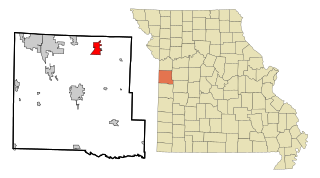
High Hill is a city in Montgomery County, Missouri, United States. The population was 186 at the 2020 census.

<span class="mw-page-title-main">New Florence, Missouri</span> City in Missouri, United States

New Florence is a city in Montgomery County, Missouri, United States. The population was 641 at the 2020 census.

<span class="mw-page-title-main">Clifton Hill, Missouri</span> City in Missouri, United States

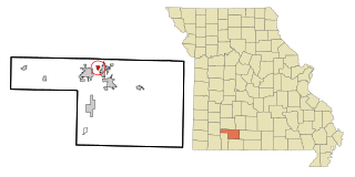
Clifton Hill is a city in Randolph County, Missouri, United States. The population was 114 at the 2010 census.

<span class="mw-page-title-main">Flint Hill, Missouri</span> City in Missouri, United States

Flint Hill is a town in northwestern St. Charles County, Missouri, United States. The population was 525 at the 2010 census.

<span class="mw-page-title-main">Park Hills, Missouri</span> City in Missouri, United States

Park Hills is a city in St. Francois County, Missouri, United States. The population was 8,587 at the 2020 census.

<span class="mw-page-title-main">Beverly Hills, Missouri</span> City in Missouri, United States

Beverly Hills is a city in St. Louis County, Missouri, United States. As of the 2010 census, the city population was 574.

<span class="mw-page-title-main">Breckenridge Hills, Missouri</span> City in Missouri, United States

Breckenridge Hills is a city in St. Louis County, Missouri, United States. As of the 2010 census, the city population was 4,746.

<span class="mw-page-title-main">Country Club Hills, Missouri</span> City in Missouri, United States

Country Club Hills is a city in St. Louis County, Missouri, United States. The population was 1,274 at the 2010 census.

<span class="mw-page-title-main">Flordell Hills, Missouri</span> City in Missouri, United States

Flordell Hills is a city in St. Louis County, Missouri, United States. The population was 822 at the 2010 census.

<span class="mw-page-title-main">Pasadena Hills, Missouri</span> City in Missouri, United States

Pasadena Hills is a city in St. Louis County, Missouri, United States. The population was 930 at the 2010 census. The entire city is listed on the National Register of Historic Places.

<span class="mw-page-title-main">Sycamore Hills, Missouri</span> Village in Missouri, United States

Sycamore Hills is a village in St. Louis County, Missouri, United States. The population is 560 at the 2020 census.

<span class="mw-page-title-main">Velda City, Missouri</span> City in Missouri, United States

Velda City is a city in St. Louis County, Missouri, United States. The population was 1,420 at the 2010 census.

<span class="mw-page-title-main">Velda Village Hills, Missouri</span> City in Missouri, United States

Velda Village Hills is a city in northeastern St. Louis County, Missouri, United States. The population was 1,055 at the 2010 census.

<span class="mw-page-title-main">Hanley Hills, Missouri</span> Village in Missouri, United States

Hanley Hills is a village in St. Louis County, Missouri, United States. The population was 2,101 at the 2010 census.

<span class="mw-page-title-main">Sunset Hills, Missouri</span> City in Missouri, United States

Sunset Hills is a city in south St. Louis County, Missouri, United States. As of the 2020 United States Census, the city's population was 9,198.

References

  1. "ArcGIS REST Services Directory". United States Census Bureau. Retrieved August 28, 2022.
  2. 1 2 U.S. Geological Survey Geographic Names Information System: Rich Hill, Missouri
  3. 1 2 "U.S. Census website". United States Census Bureau . Retrieved January 31, 2008.
  4. Earngey, Bill (1995). Missouri Roadsides: The Traveler's Companion. University of Missouri Press. p. 30. ISBN   9780826210210.
  5. "Coal mining key part of Rich Hill's history". Nevada Daily Mail. May 4, 2012. Retrieved June 18, 2018.
  6. "National Register of Historic Places Listings". Weekly List of Actions Taken on Properties: 9/08/15 through 9/11/15. National Park Service. September 18, 2015.
  7. Missouri Atlas & Gazetteer, DeLorme, 1998, First edition, p. 42, ISBN   0-89933-224-2
  8. "US Gazetteer files 2010". United States Census Bureau. Archived from the original on January 12, 2012. Retrieved July 8, 2012.
  9. "Census of Population and Housing". Census.gov. Retrieved June 4, 2015.
  10. "U.S. Census website". United States Census Bureau . Retrieved July 8, 2012.
  11. "Our History". American Broadband. Retrieved June 4, 2019.
  12. "Homepage". Rich Hill R-Iv School District. Retrieved June 4, 2019.
  13. "Missouri Public Libraries". PublicLibraries.com. Archived from the original on June 10, 2017. Retrieved June 2, 2019.
  14. "Missouri Bus Stops" . Retrieved July 21, 2023.