Rockville, Missouri

Last updated

Rockville, Missouri
Bates County Missouri Incorporated and Unincorporated areas Rockville Highlighted.svg
Location of Rockville, Missouri
Coordinates: 38°4′14″N94°4′49″W / 38.07056°N 94.08028°W / 38.07056; -94.08028
Country United States
State Missouri
County Bates
Area
[1]
  Total0.33 sq mi (0.85 km2)
  Land0.33 sq mi (0.85 km2)
  Water0.00 sq mi (0.00 km2)
Elevation
[2]
771 ft (235 m)
Population
 (2020)
  Total135
  Density410.33/sq mi (158.26/km2)
Time zone UTC-6 (Central (CST))
  Summer (DST) UTC-5 (CDT)
ZIP code
64780
Area code 660
FIPS code 29-62786 [3]
GNIS feature ID2396410 [2]

Rockville is a city in Bates County, Missouri, and is part of the Kansas City metropolitan area within the United States. The population was 135 at the 2020 census.

Contents

History

Rockville was laid out in 1868. [4] The city was named from local white sandstone quarries. [5] A post office called Rockville has been in operation since 1871. [6]

Geography

Rockville is located at 38°4′14″N94°4′49″W / 38.07056°N 94.08028°W / 38.07056; -94.08028 (38.070435, -94.080404). [7]

According to the United States Census Bureau, the city has a total area of 0.33 square miles (0.85 km2), all land. [8]

The community is in the southeast corner of Bates County approximately 18 miles southeast of Butler and on the north shore of the Harry S Truman Reservoir. Schell City is across the lake and four miles to the southwest in adjacent Vernon County. [9]

Demographics

Historical population
CensusPop.Note
1880 315
1890 55475.9%
1900 5804.7%
1910 566−2.4%
1920 486−14.1%
1930 408−16.0%
1940 336−17.6%
1950 37210.7%
1960 255−31.5%
1970 203−20.4%
1980 28138.4%
1990 193−31.3%
2000 162−16.1%
2010 1662.5%
2020 135−18.7%
U.S. Decennial Census [10]

2010 census

As of the census [11] of 2010, there were 166 people, 72 households, and 38 families living in the city. The population density was 503.0 inhabitants per square mile (194.2/km2). There were 103 housing units at an average density of 312.1 per square mile (120.5/km2). The racial makeup of the city was 95.8% White, 0.6% African American, 0.6% Asian, and 3.0% from two or more races. Hispanic or Latino of any race were 2.4% of the population.

There were 72 households, of which 27.8% had children under the age of 18 living with them, 40.3% were married couples living together, 8.3% had a female householder with no husband present, 4.2% had a male householder with no wife present, and 47.2% were non-families. 38.9% of all households were made up of individuals, and 20.8% had someone living alone who was 65 years of age or older. The average household size was 2.31 and the average family size was 3.21.

The median age in the city was 45 years. 23.5% of residents were under the age of 18; 7.1% were between the ages of 18 and 24; 19.2% were from 25 to 44; 33.6% were from 45 to 64; and 16.3% were 65 years of age or older. The gender makeup of the city was 48.8% male and 51.2% female.

2000 census

As of the census [3] of 2000, there were 162 people, 77 households, and 39 families living in the city. The population density was 504.8 inhabitants per square mile (194.9/km2). There were 103 housing units at an average density of 320.9 per square mile (123.9/km2). The racial makeup of the city was 97.53% White, 0.62% African American, and 1.85% from two or more races. Hispanic or Latino of any race were 1.85% of the population.

There were 77 households, out of which 20.8% had children under the age of 18 living with them, 37.7% were married couples living together, 7.8% had a female householder with no husband present, and 48.1% were non-families. 41.6% of all households were made up of individuals, and 23.4% had someone living alone who was 65 years of age or older. The average household size was 2.10 and the average family size was 2.83.

In the city the population was spread out, with 19.8% under the age of 18, 5.6% from 18 to 24, 24.1% from 25 to 44, 27.2% from 45 to 64, and 23.5% who were 65 years of age or older. The median age was 46 years. For every 100 females, there were 100.0 males. For every 100 females age 18 and over, there were 106.3 males.

The median income for a household in the city was $19,219, and the median income for a family was $21,250. Males had a median income of $29,583 versus $11,786 for females. The per capita income for the city was $12,730. About 33.3% of families and 32.1% of the population were below the poverty line, including 59.3% of those under the age of eighteen and 16.7% of those 65 or over.

Related Research Articles

<span class="mw-page-title-main">Rockville, Indiana</span> Town in Indiana, United States

Rockville is a town in Adams Township, Parke County, in the U.S. state of Indiana. The population was 2,607 at the 2010 census. The town is the county seat of Parke County. It is known as "The Covered Bridge Capital of the World".

Greenbush, officially the Town of Greenbush, is a town in Penobscot County, Maine, United States, on the Penobscot River. The town's population was 1,444 at the 2020 United States Census.

Moscow is a town in Somerset County, Maine, United States. The population was 475 at the 2020 census.

<span class="mw-page-title-main">Onamia, Minnesota</span> City in Minnesota, United States

Onamia is a city in Mille Lacs County, Minnesota, United States. The population was 878 at the 2010 census. U.S. Highway 169 and Minnesota State Highway 27 are the main routes in the community.

<span class="mw-page-title-main">Rosendale, Missouri</span> City in Missouri, United States

Rosendale is a city in Andrew County, Missouri, United States. The population was 143 at the 2010 census.

<span class="mw-page-title-main">St. Martins, Missouri</span> City in Missouri, United States

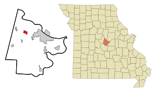
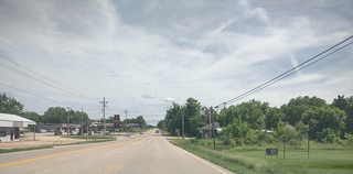
St. Martins or Saint Martins is a city in Cole County, Missouri, United States. The population was 1,191 at the 2020 census. It is part of the Jefferson City, Missouri Metropolitan Statistical Area.

<span class="mw-page-title-main">Urbana, Missouri</span> City in Missouri, United States

Urbana is a city in Dallas County, Missouri, United States. The population was 414 at the 2010 census. It is part of the Springfield, Missouri Metropolitan Statistical Area.

<span class="mw-page-title-main">Pattonsburg, Missouri</span> City in Missouri, United States

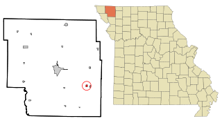
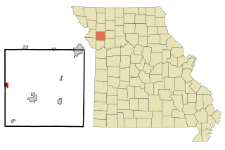
Pattonsburg is a city in northwest Daviess County, Missouri, United States. The population was 314 at the 2020 census.

<span class="mw-page-title-main">Blairstown, Missouri</span> City in Missouri, United States

Blairstown is a village in Henry County, Missouri, United States. The population was 97 at the 2010 census. A post office, and a firearms store are located there.

<span class="mw-page-title-main">Deepwater, Missouri</span> City in Missouri, United States

Deepwater is a city in Henry County, Missouri, United States. The population was 433 at the 2010 census.

<span class="mw-page-title-main">Grandview, Missouri</span> City in Missouri, United States

Grandview is a city in Jackson County, Missouri, United States. The population was 24,475 at the 2010 census. It is part of the Kansas City metropolitan area.

<span class="mw-page-title-main">Conception Junction, Missouri</span> City in Missouri, United States

Conception Junction is a city in Nodaway County, Missouri, United States, near the Platte River. The population was 198 at the 2010 census, at which time it was a town.

<span class="mw-page-title-main">Nelson, Missouri</span> City in Missouri, United States

Nelson is a city in Saline County, Missouri, United States. The population was 152 at the 2020 census.

<span class="mw-page-title-main">West Alton, Missouri</span> City in Missouri, United States

West Alton is a city in St. Charles County, Missouri, United States. The population was 359 at the 2020 census. It is located at the tip of the peninsula formed by the confluence of the Missouri and Mississippi Rivers and is directly across Alton, Illinois.

<span class="mw-page-title-main">Hazelwood, Missouri</span> City in Missouri, United States

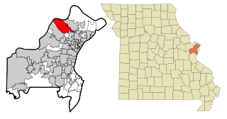
Hazelwood is a city in St. Louis County, Missouri, within Greater St. Louis. It is a second-ring northern suburb of St. Louis. Based on the 2020 United States census, the city had a total population of 25,485. It is located north of St. Louis-Lambert International Airport and is situated on Interstates 270 and 170, as well as the much-traveled Lindbergh Boulevard and Highway 370.

<span class="mw-page-title-main">Jennings, Missouri</span> City in Missouri, United States

Jennings is a city in St. Louis County, Missouri, United States. Per the 2020 census, the population was 12,895.

<span class="mw-page-title-main">Velda Village Hills, Missouri</span> City in Missouri, United States

Velda Village Hills is a city in northeastern St. Louis County, Missouri, United States. The population was 1,055 at the 2010 census.

<span class="mw-page-title-main">Wildwood, Missouri</span> City in Missouri, United States

Wildwood is a city in St. Louis County, Missouri, United States. It is located in the far western portion of the county. As of the 2020 census, the population was 35,417. Wildwood is the home of the Al Foster Trail, and numerous other trails, parks, and reserves such as Rockwoods Reservation and Babler State Park.

<span class="mw-page-title-main">Ionia, Missouri</span> Village in Missouri, United States

Ionia is a village in northern Benton and southern Pettis counties in the U.S. state of Missouri. The population was 88 at the 2010 census.

<span class="mw-page-title-main">Gower, Missouri</span> City in Missouri, United States

Gower is a city in Buchanan and Clinton counties in the U.S. state of Missouri and is part of the Kansas City metropolitan area. The population was 1,526 at the 2010 census.

References

  1. "ArcGIS REST Services Directory". United States Census Bureau. Retrieved August 28, 2022.
  2. 1 2 U.S. Geological Survey Geographic Names Information System: Rockville, Missouri
  3. 1 2 "U.S. Census website". United States Census Bureau . Retrieved January 31, 2008.
  4. "Bates County Place Names, 1928-1945 (archived)". The State Historical Society of Missouri. Archived from the original on June 24, 2016. Retrieved September 1, 2016.{{cite web}}: CS1 maint: bot: original URL status unknown (link)
  5. Eaton, David Wolfe (1916). How Missouri Counties, Towns and Streams Were Named. The State Historical Society of Missouri. pp.  208.
  6. "Post Offices". Jim Forte Postal History. Retrieved September 1, 2016.
  7. "US Gazetteer files: 2010, 2000, and 1990". United States Census Bureau. February 12, 2011. Retrieved April 23, 2011.
  8. "US Gazetteer files 2010". United States Census Bureau. Archived from the original on July 2, 2012. Retrieved July 8, 2012.
  9. Missouri Atlas & Gazetteer, DeLorme, 1st ed. 1998, p. 42 ISBN   0899332242
  10. "Census of Population and Housing". Census.gov. Retrieved June 4, 2015.
  11. "U.S. Census website". United States Census Bureau . Retrieved July 8, 2012.