Boswell, Indiana

Last updated

Boswell, Indiana
Boswell, Indiana watertower.png
Nickname: 
Hub of the Universe
Benton County Indiana Incorporated and Unincorporated areas Boswell Highlighted 1806706.svg
Location of Boswell in Benton County, Indiana.
Location map for Benton County, Indiana.svg
Red pog.svg
Boswell, Indiana
Boswell's location in Benton County
Coordinates: 40°31′02″N87°22′31″W / 40.51722°N 87.37528°W / 40.51722; -87.37528
Country United States
State Indiana
County Benton
Township Grant
Founded1872
Area
[1]
  Total0.88 sq mi (2.29 km2)
  Land0.88 sq mi (2.29 km2)
  Water0.00 sq mi (0.00 km2)
Elevation
[2]
755 ft (230 m)
Population
 (2020)
  Total800
  Density904.98/sq mi (349.41/km2)
Time zone UTC-5 (EST)
  Summer (DST) UTC-4 (EDT)
ZIP code
47921
Area code 765
FIPS code [3] 18-06706
GNIS ID2396598 [2]
Website https://www.townofboswell.com/

Boswell is a town in Grant Township, Benton County, Indiana, United States. The population was 778 at the 2010 census. It is part of the Lafayette, Indiana Metropolitan Statistical Area.

Contents

History

The town of Boswell was first laid out by Charles Moore, but Moore sold the land it occupied to Tippecanoe County-native Elizabeth H. Scott who, with her husband Charles, replatted it in its present form on July 18, 1872. A small general store run from a "rough board shanty" just north of the railroad was the town's first business, but this was joined by many more as the town grew. [4] The town was named for Parnaham Boswell and was platted with streets bearing the names of the founders, Charles and Elizabeth, and their five children, Grace, Emma, Clinton, Harold and Jennie. [5]

Geography

Boswell is located in Grant Township. U.S. Route 41 passes along the east side of Boswell; State Road 352 and the Kankakee, Beaverville and Southern Railroad both run east through town. Goose Creek flows along Boswell's south side and joins Mud Pine Creek about two miles to the southeast. [2]

According to the 2010 census, Boswell has a total area of 0.93 square miles (2.41 km2), all land. [6]

Government and public safety

The town's business is presided over by a three-person town board and a town clerk. These positions are elected every four years.

The town of Boswell employees a full-time town marshal as well as a part-time deputy marshal. The Marshal is charged with providing law enforcement service in the town limits and surrounding area. The town marshal is a sworn police officer under Indiana statute.

Demographics

Historical population
CensusPop.Note
1880 330
1890 55869.1%
1900 82447.7%
1910 814−1.2%
1920 8808.1%
1930 817−7.2%
1940 8777.3%
1950 9639.8%
1960 957−0.6%
1970 9984.3%
1980 810−18.8%
1990 767−5.3%
2000 8277.8%
2010 778−5.9%
2020 8002.8%
U.S. Decennial Census [7]

2010 census

As of the 2010 census, [8] there were 778 people, 310 households, and 205 families living in the town. The population density was 836.6 inhabitants per square mile (323.0/km2). There were 362 housing units at an average density of 389.2 per square mile (150.3/km2). The racial makeup of the town was 87.9% White, 0.6% African American, 0.3% Native American, 0.1% Asian, 10.2% from other races, and 0.9% from two or more races. Hispanic or Latino of any race were 15.0% of the population.

There were 310 households, of which 33.2% had children under the age of 18 living with them, 47.4% were married couples living together, 13.5% had a female householder with no husband present, 5.2% had a male householder with no wife present, and 33.9% were non-families. 30.0% of all households were made up of individuals, and 16.1% had someone living alone who was 65 years of age or older. The average household size was 2.51 and the average family size was 3.08.

The median age in the town was 38.1 years. 27.6% of residents were under the age of 18; 5.9% were between the ages of 18 and 24; 28.3% were from 25 to 44; 22% were from 45 to 64; and 16.2% were 65 years of age or older. The gender makeup of the town was 47.9% male and 52.1% female.

2000 census

As of the 2000 census, [9] there were 827 people, 329 households, and 224 families living in the town. The population density was 1,743.3 inhabitants per square mile (673.1/km2). There were 361 housing units at an average density of 761.0 per square mile (293.8/km2). The racial makeup of the town was 92.14% White, 0.24% African American, 0.24% Native American, 0.24% Asian, 4.84% from other races, and 2.30% from two or more races. Hispanic or Latino of any race were 9.79% of the population.

There were 329 households, out of which 31.3% had children under the age of 18 living with them, 54.1% were married couples living together, 10.6% had a female householder with no husband present, and 31.9% were non-families. 28.3% of all households were made up of individuals, and 17.6% had someone living alone who was 65 years of age or older. The average household size was 2.51 and the average family size was 3.08.

In the town, the population was spread out, with 28.7% under the age of 18, 6.4% from 18 to 24, 28.2% from 25 to 44, 16.7% from 45 to 64, and 20.1% who were 65 years of age or older. The median age was 36 years. For every 100 females, there were 85.0 males. For every 100 females age 18 and over, there were 81.0 males.

The median income for a household in the town was $33,224, and the median income for a family was $36,136. Males had a median income of $28,839 versus $19,792 for females. The per capita income for the town was $14,401. About 5.5% of families and 8.3% of the population were below the poverty line, including 7.2% of those under age 18 and 3.9% of those age 65 or over.

Education

The town has a lending library, the Boswell Public Library. [10]

Related Research Articles

<span class="mw-page-title-main">Ambia, Indiana</span> Town in Indiana, United States

Ambia is a town in Hickory Grove Township, Benton County, Indiana, United States. The population was 239 at the 2010 census. It is part of the Lafayette, Indiana Metropolitan Statistical Area.

<span class="mw-page-title-main">Earl Park, Indiana</span> Town in Indiana, United States

Earl Park is a town in Richland Township, Benton County, Indiana, United States. The population was 348 at the 2010 census. It is part of the Lafayette, Indiana Metropolitan Statistical Area.

<span class="mw-page-title-main">Fowler, Indiana</span> Town in Indiana, United States

Fowler is a town in, and county seat of Center Township, Benton County, Indiana, United States. The population was 2,337 at the 2020 census. It is part of the Lafayette, Indiana Metropolitan Statistical Area.

<span class="mw-page-title-main">Otterbein, Indiana</span> Town in Indiana, United States

Otterbein is a town in Shelby Township, Tippecanoe County and Bolivar Township, Benton County, Indiana, named for William Otterbein Brown who donated land for the town. As of the 2010 census, its population was 1,262.

<span class="mw-page-title-main">Jamestown, Indiana</span> Town in Indiana, United States

Jamestown is a town in Jackson Township, Boone County and Eel River Township, Hendricks County, Indiana, United States. The population was 958 at the 2010 census.

<span class="mw-page-title-main">Thorntown, Indiana</span> Town in Indiana, United States

Thorntown is a town in Sugar Creek Township, Boone County, Indiana. The population was 1,520 at the time of the 2010 census. Thorntown is located in northwestern Boone County, about halfway between Lafayette and Indianapolis.

<span class="mw-page-title-main">Brazil, Indiana</span> City in Indiana, United States

Brazil is a city in Clay County, Indiana, United States. The population was 8,176 at the 2022 census. The city is the county seat of Clay County. It is part of the Terre Haute Metropolitan Statistical Area.

<span class="mw-page-title-main">Vernon, Indiana</span> Town in Indiana, United States

Vernon is a town within Vernon Township and the county seat of Jennings County, Indiana, United States. With a population of 318 in the 2010 census, it is the smallest town with that designation in the state of Indiana, lying just south of the much larger North Vernon. It is nearly surrounded by the Muscatatuck River. Vernon is the only Indiana town with an elected mayor and an elected town marshal. As of 2023, Marshall Zamora is the mayor and Britt Burgmeier is the marshal.

<span class="mw-page-title-main">Bicknell, Indiana</span> City in Indiana, United States

Bicknell is a city in Knox County, Indiana, United States. The population was 2,915 at the 2010 census.

<span class="mw-page-title-main">Argos, Indiana</span> American town in Indiana

Argos is a town in Green and Walnut townships, Marshall County, Indiana, United States. The population was 1,777 at the 2020 census.

<span class="mw-page-title-main">Bremen, Indiana</span> Town in Indiana, United States

Bremen is a town in German Township, Marshall County, Indiana, United States. The population was 4,696 at the 2020 census.

<span class="mw-page-title-main">Waynetown, Indiana</span> Town in Indiana, United States

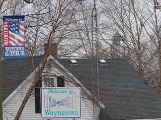
Waynetown is a town in Wayne Township, Montgomery County, in the U.S. state of Indiana. The population was 960 at the 2020 census.

<span class="mw-page-title-main">Wingate, Indiana</span> Town in Indiana, United States

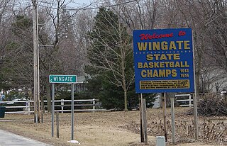
Wingate, formerly known as "Pleasant Hill", is a town in Coal Creek Township, Montgomery County, in the U.S. state of Indiana. The population was 237 at the 2020 census.

<span class="mw-page-title-main">Paragon, Indiana</span> Town in Indiana, United States

Paragon is a town in Ray Township, Morgan County, in the U.S. state of Indiana. The population was 556 at the 2020 census, down from 659 in 2010.

<span class="mw-page-title-main">Avilla, Indiana</span> Town in Indiana, United States

Avilla is a town in Allen Township, Noble County, in the U.S. state of Indiana. The population was 2,401 at the 2010 census.

<span class="mw-page-title-main">Hudson, Indiana</span> Town in Indiana, United States

Hudson is a town in Salem and Steuben townships, Steuben County, in the U.S. state of Indiana. The population was 518 at the 2010 census.

<span class="mw-page-title-main">Fairview Park, Indiana</span> Town in Indiana, United States

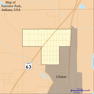
Fairview Park is a town in Clinton Township, Vermillion County, in the U.S. state of Indiana. The population was 1,386 at the 2010 census.

<span class="mw-page-title-main">Benton, Missouri</span> City in Missouri, United States

Benton is a city in Scott County, Missouri, United States. The population was 863 at the 2010 census. It is the county seat of Scott County.

<span class="mw-page-title-main">Benton Ridge, Ohio</span> Village in Ohio, United States

Benton Ridge is a village in Hancock County, Ohio, United States. The population was 272 at the 2020 census. It is within the boundaries of the Liberty-Benton Local School district.

<span class="mw-page-title-main">Millersburg, Indiana</span> Town in Indiana, United States

Millersburg is a town in Clinton and Benton townships, Elkhart County, Indiana, United States. The population was 903 at the 2010 census.

References

  1. "2020 U.S. Gazetteer Files". United States Census Bureau. Retrieved March 16, 2022.
  2. 1 2 3 U.S. Geological Survey Geographic Names Information System: Boswell, Indiana
  3. "FIPS55 Data: Indiana". FIPS55 Data. United States Geological Survey. February 23, 2006. Archived from the original on June 18, 2006. Retrieved June 30, 2014.
  4. Mossman, Ed (1883). "History of Benton County: Past Events -- Present Condition". Counties of Warren, Benton, Jasper and Newton, Indiana: Historical and Biographical. Chicago: F. A. Battey & Co.
  5. Birch, Jesse Setlington (1942) [1928]. "Towns of the County". History of Benton County and Historic Oxford. Oxford, Indiana: Craw & Craw. p. 201.
  6. "G001 - Geographic Identifiers - 2010 Census Summary File 1". United States Census Bureau. Archived from the original on February 13, 2020. Retrieved July 13, 2015.
  7. "Census of Population and Housing". Census.gov. Retrieved June 4, 2015.
  8. "U.S. Census website". United States Census Bureau . Retrieved December 11, 2012.
  9. "U.S. Census website". United States Census Bureau . Retrieved January 31, 2008.
  10. "Benton County Libraries". Benton County, IN. Retrieved March 4, 2018.