Wadena, Indiana

Last updated

Wadena, Indiana
Wadena, Indiana street.png
A street corner in the small town of Wadena
Map of Indiana highlighting Benton County.svg
Benton County's location in Indiana
Location map for Benton County, Indiana.svg
Red pog.svg
Wadena
Freeland Park's location in Benton County
Coordinates: 40°41′36″N87°16′36″W / 40.69333°N 87.27667°W / 40.69333; -87.27667
Country United States
State Indiana
County Benton
Township Union
Named for Wadena, Minnesota
Elevation
[1]
797 ft (243 m)
Time zone UTC-5 (Eastern (EST))
  Summer (DST) UTC-4 (EDT)
ZIP code
47944
Area code 765
FIPS code 18-79424 [2]
GNIS feature ID 445342

Wadena is an unincorporated community in Union Township, Benton County, in the U.S. state of Indiana. [3] It is part of the Lafayette, Indiana Metropolitan Statistical Area.

Contents

History

Benton County Railroad Map, circa 1896, showing the location of Wadena Benton County Railroad Map, circa 1896.png
Benton County Railroad Map, circa 1896, showing the location of Wadena

Wadena was founded by John Swan and named after Wadena, Minnesota, a town Swan had recently visited and found pleasing. [4] The name derives from an Ojibwa term meaning "little round hill". [5] The town was situated along a north/south rail line constructed through Benton County in the 1880s, originally operated as the Chicago and Great Southern Railway and later as the Chicago and Indiana Coal Railway, the Chicago and Eastern Illinois Railroad, and ultimately the Chicago, Attica and Southern Railroad which maintained the line until its abandonment in the 1940s. The line was also commonly known as the Coal Road and the Dolly Varden Line. [6]

A post office was established at Wadena in 1883, and remained in operation until it was discontinued in 1919. [7]

In the early 20th century, four Wadena residents gained national repute as professional baseball players: [4]

Wadena currently consists of several private residences and a defunct Baptist church that burned down. A monument east of town commemorates Wadena School, which served the township's students from 1895 to 1961.

Geography

Wadena is located at 40°41′36″N87°16′36″W / 40.69333°N 87.27667°W / 40.69333; -87.27667 along Benton County Road 600 North in Union Township, midway between 200 East and 300 East.

Big Pine Creek Ditch begins in the fields just west of town and flows southeast approximately six miles to Big Pine Creek. Carpenter Creek, which meets the Iroquois River about 14 miles to the north, begins northeast of Wadena. Mount Nebo, the highest point in Benton County, stands a little less than two miles to the east. [8]

Related Research Articles

<span class="mw-page-title-main">Warren County, Indiana</span> County in Indiana, United States

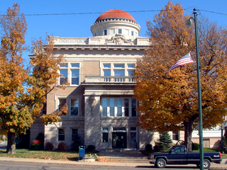
Warren County is a county in the U.S. state of Indiana. It lies in the western part of the state between the Illinois state line and the Wabash River. According to the 2020 census, it had a population of 8,440. Its county seat is Williamsport.

<span class="mw-page-title-main">Boswell, Indiana</span> Town in Indiana, United States

Boswell is a town in Grant Township, Benton County, Indiana, United States. The population was 778 at the 2010 census. It is part of the Lafayette, Indiana Metropolitan Statistical Area.

<span class="mw-page-title-main">Pine Village, Indiana</span> Town in Indiana, United States

Pine Village is a town in Adams Township, Warren County, in the U.S. state of Indiana. The population was 217 at the 2010 census.

<span class="mw-page-title-main">Judyville, Indiana</span> Unincorporated community in Indiana, United States

Judyville is a small unincorporated community in Liberty Township, Warren County, in the U.S. state of Indiana.

Winthrop is a small unincorporated community in Warren Township, Warren County, in the U.S. state of Indiana.

<span class="mw-page-title-main">Templeton, Indiana</span> Unincorporated community in Indiana, United States

Templeton is an unincorporated community in Bolivar Township, Benton County, in the U.S. state of Indiana. It is part of the Lafayette, Indiana Metropolitan Statistical Area.

<span class="mw-page-title-main">Talbot, Indiana</span> Unincorporated community in Indiana, United States

Talbot is an unincorporated community in Hickory Grove Township, Benton County, in the U.S. state of Indiana. It is part of the Lafayette, Indiana Metropolitan Statistical Area.

<span class="mw-page-title-main">Swanington, Indiana</span> Unincorporated community in Indiana, United States

Swanington is an unincorporated community in Center Township, Benton County, in the U.S. state of Indiana. It is part of the Lafayette, Indiana Metropolitan Statistical Area.

<span class="mw-page-title-main">Dunnington, Indiana</span> Unincorporated community in Indiana, United States

Dunnington is a small unincorporated community in Parish Grove Township, Benton County, in the U.S. state of Indiana.

<span class="mw-page-title-main">Freeland Park, Indiana</span> Unincorporated town in Indiana, United States

Freeland Park is an unincorporated town in Parish Grove Township, Benton County, in the U.S. state of Indiana. It is part of the Lafayette, Indiana Metropolitan Statistical Area.

<span class="mw-page-title-main">Atkinson, Indiana</span> Unincorporated community in Indiana, United States

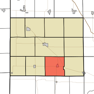
Atkinson is an unincorporated community in Center Township, Benton County, in the U.S. state of Indiana. The site of Atkinson is home to the county's only junior/senior high school, Benton Central.

<span class="mw-page-title-main">Chase, Indiana</span> Unincorporated community in Indiana, United States

Chase is an unincorporated community in Grant Township, Benton County, in the U.S. state of Indiana. Though virtually extinct, Chase still persists on state and county maps and retains a single business in the form of grain elevators operated by Boswell Chase Grain, Inc. A few miles away is the Daughtery Motor Speedway.

<span class="mw-page-title-main">Oak Grove Township, Benton County, Indiana</span> Township in Indiana, United States

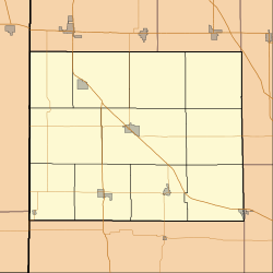
Oak Grove Township is one of eleven townships in Benton County, Indiana. As of the 2020 census, its population was 1,551 and it contained 690 housing units. It was one of the first three townships originally created by the county's commissioners in 1840. It takes its name from White Oak Grove which grew southwest of Oxford.

<span class="mw-page-title-main">Parish Grove Township, Benton County, Indiana</span> Township in Indiana, United States

Parish Grove Township is one of eleven townships in Benton County, Indiana. As of the 2020 census, its population was 185 and it contained 89 housing units. It contains the unincorporated town of Freeland Park.

<span class="mw-page-title-main">Pine Township, Benton County, Indiana</span> Township in Indiana, United States

Pine Township is one of eleven townships in Benton County, Indiana. As of the 2020 census, its population was 324 and it contained 108 housing units. Pine Township was one of the original three created by county commissioners in July 1840, and is named for Big Pine Creek which flows south through the township.

<span class="mw-page-title-main">Union Township, Benton County, Indiana</span> Township in Indiana, United States

Union Township is one of eleven townships in Benton County, Indiana. As of the 2020 census, its population was 283 and it contained 92 housing units. The township was organized in June 1864 and named by John W. Nutt "because of the loyalty shown in furnishing soldiers for the Union army."

<span class="mw-page-title-main">West Point Township, White County, Indiana</span> Township in Indiana, United States

West Point Township is one of twelve townships in White County, Indiana, United States. As of the 2010 census, its population was 381 and it contained 141 housing units.

<span class="mw-page-title-main">Dunn, Indiana</span> Extinct town in Indiana, United States

Dunn is an extinct town in Hickory Grove Township, Benton County, in the U.S. state of Indiana.

<span class="mw-page-title-main">Barce, Indiana</span> Unincorporated community in Indiana, United States

Barce is an unincorporated community in Center Township, Benton County, in the U.S. state of Indiana.

<span class="mw-page-title-main">Lee, Indiana</span> Unincorporated community in Indiana, United States

Lee is an unincorporated community in Monon Township, White County, in the U.S. state of Indiana.

References

  1. "US Board on Geographic Names". United States Geological Survey. October 25, 2007. Retrieved January 31, 2008.
  2. "U.S. Census website". United States Census Bureau . Retrieved January 31, 2008.
  3. "Wadena, Indiana". Geographic Names Information System . United States Geological Survey . Retrieved February 29, 2020.
  4. 1 2 Birch, Jesse Setlington (1942) [1928]. "Unincorporated community s of the County". History of Benton County and Historic Oxford. Oxford, Indiana: Craw & Craw. pp. 200–201.
  5. Allison, Harold (1986). "Appendix: Indiana Indian Place Names". The Tragic Saga of the Indiana Indians. Paducah, Kentucky: Graphic Design of Indiana. p. 314. ISBN   0-938021-07-9.
  6. Elmer G., Sulzer (1970). Ghost Railroads of Indiana. Indianapolis: Jones and Co.
  7. "Benton County". Jim Forte Postal History. Retrieved February 29, 2020.
  8. "Topographic map of Wadena area". The National Map . USGS via MSR Maps . Retrieved December 12, 2008.