Ambia, Indiana

Last updated

Ambia, Indiana
Ambia, Indiana sign.png
Benton County Indiana Incorporated and Unincorporated areas Ambia Highlighted 1801342.svg
Location of Ambia in Benton County, Indiana.
Location map for Benton County, Indiana.svg
Red pog.svg
Ambia, Indiana
Ambia's location in Benton County
Coordinates: 40°29′22″N87°30′59″W / 40.48944°N 87.51639°W / 40.48944; -87.51639 [1]
Country United States
State Indiana
County Benton
Township Hickory Grove
Founded1875
Area
[2]
  Total0.15 sq mi (0.39 km2)
  Land0.15 sq mi (0.39 km2)
  Water0.00 sq mi (0.00 km2)
Elevation
[1]
738 ft (225 m)
Population
 (2020)
  Total227
  Density1,503.31/sq mi (580.60/km2)
Time zone UTC-5 (EST)
  Summer (DST) UTC-4 (EDT)
ZIP code
47917
Area code 765
FIPS code 18-01342
GNIS ID2397427 [1]

Ambia is a town in Hickory Grove Township, Benton County, Indiana, United States. The population was 239 at the 2010 census. It is part of the Lafayette, Indiana Metropolitan Statistical Area.

Contents

History

Ambia, Store Front with the Post Office, Old Harness Shop, Barber Shop, and Millinery Shop, circa 1920 Ambia downtown Indiana historic.jpg
Ambia, Store Front with the Post Office, Old Harness Shop, Barber Shop, and Millinery Shop, circa 1920

Ambia was laid out by Ezekiel M. Talbot and his wife Marietta on February 22, 1875, and named for their daughter Ambia Talbot. (The couple had two years earlier planned the nearby town of Talbot.) Its first building was a house erected by James C. Pugh which was soon joined by a grain elevator, general store and blacksmith. A drug store, hardware store, hotel, physician and a variety of other establishments followed. [3]

Ambia was a stop on the Lafayette, Muncie and Bloomington Railroad (later the Lake Erie and Western) which ran between Lafayette and Hoopeston. The Wabash Railway Company, which built a stretch of the LM&B through Illinois, originally wanted to construct a railway switch at a site known as Weaver City, a small town just west of Ambia in Vermilion County, Illinois; the owner of the property, however, refused to grant land for it. In response, the railway officials sent a force of men without notice to move the station house from Weaver City half a mile east across the state border, which they did on the Sunday morning of March 10, 1873. The town's businesses and residents followed and Weaver City faded from existence while Ambia sprang up near the station's new site. [4]

Geography

Ambia is located in the extreme southwest corner of the county, in Hickory Grove Township. The Kankakee, Beaverville and Southern Railroad and Indiana State Road 352 pass through the town, and the upper end of the North Fork of the Vermilion River flows past one mile to the north. [1]

According to the 2010 census, Ambia has a total area of 0.15 square miles (0.39 km2), all land. [5]

Demographics

Historical population
CensusPop.Note
1880 253
1890 29315.8%
1900 43849.5%
1910 359−18.0%
1920 45927.9%
1930 433−5.7%
1940 60339.3%
1950 356−41.0%
1960 351−1.4%
1970 300−14.5%
1980 274−8.7%
1990 249−9.1%
2000 197−20.9%
2010 23921.3%
2020 227−5.0%
U.S. Decennial Census [6]
Ambia from the west. Ambia, Indiana.png
Ambia from the west.

2010 census

As of the 2010 census, [7] there were 239 people, 78 households, and 63 families living in the town. The population density was 1,593.3 inhabitants per square mile (615.2/km2). There were 87 housing units at an average density of 580.0 per square mile (223.9/km2). The racial makeup of the town was 77.0% White, 20.5% from other races, and 2.5% from two or more races. Hispanic or Latino of any race were 43.5% of the population.

There were 78 households, of which 50.0% had children under the age of 18 living with them, 66.7% were married couples living together, 11.5% had a female householder with no husband present, 2.6% had a male householder with no wife present, and 19.2% were non-families. 17.9% of all households were made up of individuals, and 8.9% had someone living alone who was 65 years of age or older. The average household size was 3.06 and the average family size was 3.49.

The median age in the town was 31.4 years. 34.3% of residents were under the age of 18; 7.1% were between the ages of 18 and 24; 25.1% were from 25 to 44; 24.6% were from 45 to 64; and 8.8% were 65 years of age or older. The gender makeup of the town was 50.6% male and 49.4% female.

2000 census

As of the 2000 census, [8] there were 197 people, 71 households, and 50 families living in the town. The population density was 1,350.9 inhabitants per square mile (521.6/km2). There were 85 housing units at an average density of 582.9 per square mile (225.1/km2). The racial makeup of the town was 87.31% White, 9.64% from other races, and 3.05% from two or more races. Hispanic or Latino of any race were 17.77% of the population.

There were 71 households, out of which 35.2% had children under the age of 18 living with them, 62.0% were married couples living together, 8.5% had a female householder with no husband present, and 28.2% were non-families. 26.8% of all households were made up of individuals, and 16.9% had someone living alone who was 65 years of age or older. The average household size was 2.77 and the average family size was 3.45.

In the town, the population was spread out, with 29.9% under the age of 18, 7.6% from 18 to 24, 27.4% from 25 to 44, 19.8% from 45 to 64, and 15.2% who were 65 years of age or older. The median age was 34 years. For every 100 females, there were 107.4 males. For every 100 females age 18 and over, there were 94.4 males.

The median income for a household in the town was $36,667, and the median income for a family was $38,750. Males had a median income of $30,417 versus $21,000 for females. The per capita income for the town was $14,169. None of the families and 0.5% of the population were living below the poverty line, including no under eighteens and 4.8% of those over 64.

Related Research Articles

<span class="mw-page-title-main">Boswell, Indiana</span> Town in Indiana, United States

Boswell is a town in Grant Township, Benton County, Indiana, United States. The population was 778 at the 2010 census. It is part of the Lafayette, Indiana Metropolitan Statistical Area.

<span class="mw-page-title-main">Earl Park, Indiana</span> Town in Indiana, United States

Earl Park is a town in Richland Township, Benton County, Indiana, United States. The population was 348 at the 2010 census. It is part of the Lafayette, Indiana Metropolitan Statistical Area.

<span class="mw-page-title-main">Fowler, Indiana</span> Town in Indiana, United States

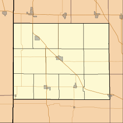
Fowler is a town in, and county seat of Center Township, Benton County, Indiana, United States. The population was 2,337 at the 2020 census. It is part of the Lafayette, Indiana Metropolitan Statistical Area.

<span class="mw-page-title-main">Otterbein, Indiana</span> Town in Indiana, United States

Otterbein is a town in Shelby Township, Tippecanoe County and Bolivar Township, Benton County, Indiana, named for William Otterbein Brown who donated land for the town. As of the 2010 census, its population was 1,262.

<span class="mw-page-title-main">Oxford, Indiana</span> Town in Indiana, United States

Oxford is a town in Oak Grove Township, Benton County, Indiana. The population was 1,162 at the 2010 census. It is part of the Lafayette, Indiana, Metropolitan Statistical Area.

<span class="mw-page-title-main">Thorntown, Indiana</span> Town in Indiana, United States

Thorntown is a town in Sugar Creek Township, Boone County, Indiana. The population was 1,520 at the time of the 2010 census. Thorntown is located in northwestern Boone County, about halfway between Lafayette and Indianapolis.

<span class="mw-page-title-main">Burlington, Indiana</span> Town in Indiana, United States

Burlington is a town in Burlington Township, Carroll County, Indiana, United States. The population was 603 at the 2010 census. It is part of the Lafayette, Indiana Metropolitan Statistical Area. State Road 22 connects it to Kokomo.

<span class="mw-page-title-main">Camden, Indiana</span> Town in Indiana, United States

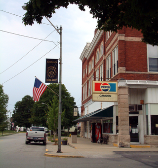
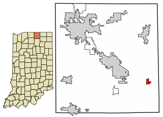
Camden is a town in Jackson Township, Carroll County, Indiana, United States. The population was 611 at the 2010 census. It is part of the Lafayette, Indiana Metropolitan Statistical Area.

<span class="mw-page-title-main">Flora, Indiana</span> Town in Indiana, United States

Flora is a town in Monroe Township, Carroll County, Indiana, United States. The population was 2,036 at the 2010 census. It is part of the Lafayette, Indiana Metropolitan Statistical Area.

<span class="mw-page-title-main">Mulberry, Indiana</span> Town in Indiana, United States

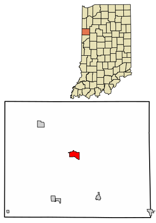
Mulberry is a town in Madison Township, Clinton County, Indiana, United States. The population was 1,231 at the 2020 census. The town was named for a mulberry tree which grew at the point where it was founded.

<span class="mw-page-title-main">Remington, Indiana</span> Town in Indiana, United States

Remington is a town in Carpenter Township, Jasper County, Indiana, United States. The population was 1,185 at the 2010 census.

<span class="mw-page-title-main">Frankton, Indiana</span> Town in Indiana, United States

Frankton is a town in Pipe Creek and Lafayette townships, Madison County, Indiana, United States. It is part of the Indianapolis–Carmel–Anderson metropolitan statistical area. The population was 1,775 at the 2020 census.

<span class="mw-page-title-main">Linden, Indiana</span> Town in Indiana, United States

Linden is a town in Madison Township, Montgomery County, in the U.S. state of Indiana. The population was 711 at the 2020 census.

New Richmond is a town in Coal Creek Township, Montgomery County, in the U.S. state of Indiana. The population was 309 at the 2020 census.

<span class="mw-page-title-main">Hudson, Indiana</span> Town in Indiana, United States

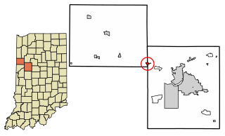
Hudson is a town in Salem and Steuben townships, Steuben County, in the U.S. state of Indiana. The population was 518 at the 2010 census.

<span class="mw-page-title-main">Clarks Hill, Indiana</span> Town in Indiana, United States

Clarks Hill is a town in Lauramie Township, Tippecanoe County, in the U.S. state of Indiana. The population was 611 at the 2010 census.

<span class="mw-page-title-main">Dayton, Indiana</span> Town in Indiana, United States

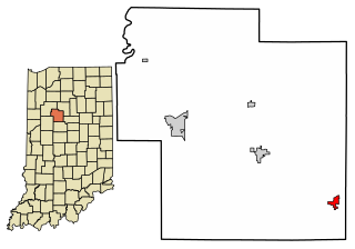
Dayton is a town in Sheffield Township, Tippecanoe County, in the U.S. state of Indiana. The population was 1,420 at the 2010 census.

<span class="mw-page-title-main">Benton, Maine</span> Town in the state of Maine, United States

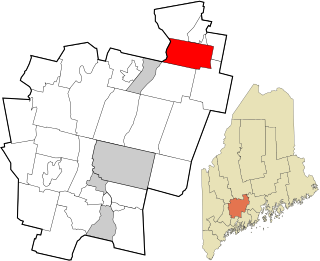
Benton is a town in Kennebec County, Maine, United States. It was formed in 1842, as a subdivision of the town of Clinton. The population was 2,715 at the 2020 census. The town was named for Missouri Senator Thomas Hart Benton.

Belmont is a town in Lafayette County, Wisconsin, United States. The population was 767 at the 2010 census, up from 676 at the 2000 census. The village of Belmont is located in the southeastern part of the town. The unincorporated community of Leslie close to the center of the town.

<span class="mw-page-title-main">Millersburg, Indiana</span> Town in Indiana, United States

Millersburg is a town in Clinton and Benton townships, Elkhart County, Indiana, United States. The population was 903 at the 2010 census.

References

  1. 1 2 3 4 U.S. Geological Survey Geographic Names Information System: Ambia, Indiana
  2. "2020 U.S. Gazetteer Files". United States Census Bureau. Retrieved March 16, 2022.
  3. Mossman, Ed (1883). "History of Benton County: Past Events -- Present Condition". Counties of Warren, Benton, Jasper and Newton, Indiana: Historical and Biographical. Chicago: F. A. Battey & Co.
  4. Birch, Jesse Setlington (1942) [1928]. "Towns of the County". History of Benton County and Historic Oxford. Oxford, Indiana: Craw & Craw. pp. 200–201.
  5. "G001 - Geographic Identifiers - 2010 Census Summary File 1". United States Census Bureau. Archived from the original on February 13, 2020. Retrieved July 13, 2015.
  6. "Census of Population and Housing". Census.gov. Retrieved June 4, 2015.
  7. "U.S. Census website". United States Census Bureau . Retrieved December 11, 2012.
  8. "U.S. Census website". United States Census Bureau . Retrieved January 31, 2008.