Earl Park, Indiana

Last updated

Earl Park, Indiana
Earl Park, Indiana park sign.png
The entrance to the town park
Benton County Indiana Incorporated and Unincorporated areas Earl Park Highlighted 1819450.svg
Location of Earl Park in Benton County, Indiana.
Location map for Benton County, Indiana.svg
Red pog.svg
Earl Park, Indiana
Earl Park's location in Benton County
Coordinates: 40°41′08″N87°25′12″W / 40.68556°N 87.42000°W / 40.68556; -87.42000 [1]
Country United States
State Indiana
County Benton
Township Richland
Area
[2]
  Total0.92 sq mi (2.39 km2)
  Land0.92 sq mi (2.39 km2)
  Water0.00 sq mi (0.00 km2)  0%
Elevation
[1]
787 ft (240 m)
Population
 (2020)
  Total370
  Density400.43/sq mi (154.54/km2)
Time zone UTC-5 (EST)
  Summer (DST) UTC-4 (EDT)
ZIP code
47942
Area code 219
FIPS code 18-19450 [3]
GNIS feature ID2396916 [1]
Website http://www.earlparkindiana.com/

Earl Park is a town in Richland Township, Benton County, Indiana, United States. The population was 348 at the 2010 census. It is part of the Lafayette, Indiana Metropolitan Statistical Area.

Contents

History

Earl Park was laid out July 31, 1872, by Adams D. Raub and named for his uncle, Adams Earl, [4] one of the promoters of the Big Four railway from Lafayette to Kankakee. It consisted of 217 lots, the public sale of which on August 8 attracted some 2,000 people. Free lunch and free transportation on a special train of freight cars from Lafayette was provided. The town's first building was a grain elevator, the second the railway station. Elias Wees opened the first general store, providing residents with groceries and provisions. [5]

Earl Park's first school, a one-story frame building, was erected around 1874 and expanded to a second story around 1878. The town gained a Catholic church in 1880, and a Methodist one in 1881, each costing about $2,500 to build and furnish. [6] Every year, Earl Park holds the Earl Park Fall Festival, which attracts thousands of people from all over the United States. It features a carnival, tractor pull, flea market, demolition derby, and some of the finest Blue Grass bands in the United States.

Earl Park is home to the Benton County Wind Farm, the first large wind farm in Indiana, established in 2008.

Earl Park was the birthplace of Matilde E. Moisant, the second woman in the United States to receive a pilot's license.

Geography

Earl Park is located in Richland Township. U.S. Route 52 skirts around the northeast edge of town, and the Kankakee, Beaverville and Southern Railroad along the southwest. The Upper Sugar Creek flows to the town's north and west.

According to the 2010 census, Earl Park has a total area of 0.94 square miles (2.43 km2), all land. [7]

Demographics

Historical population
CensusPop.Note
1900 563
1910 6098.2%
1920 542−11.0%
1930 501−7.6%
1940 5071.2%
1950 488−3.7%
1960 55112.9%
1970 478−13.2%
1980 469−1.9%
1990 443−5.5%
2000 4859.5%
2010 348−28.2%
2020 3706.3%
U.S. Decennial Census [8]

2010 census

As of the census [9] of 2010, there were 348 people, 147 households, and 93 families living in the town. The population density was 370.2 inhabitants per square mile (142.9/km2). There were 179 housing units at an average density of 190.4 per square mile (73.5/km2). The racial makeup of the town was 98.3% White, 1.4% from other races, and 0.3% from two or more races. Hispanic or Latino of any race were 2.6% of the population.

There were 147 households, of which 27.9% had children under the age of 18 living with them, 49.0% were married couples living together, 8.8% had a female householder with no husband present, 5.4% had a male householder with no wife present, and 36.7% were non-families. 26.5% of all households were made up of individuals, and 8.1% had someone living alone who was 65 years of age or older. The average household size was 2.35 and the average family size was 2.86.

The median age in the town was 42 years. 20.1% of residents were under the age of 18; 10.6% were between the ages of 18 and 24; 22.4% were from 25 to 44; 32.1% were from 45 to 64; and 14.7% were 65 years of age or older. The gender makeup of the town was 53.2% male and 46.8% female.

2000 census

As of the census [3] of 2000, there were 485 people, 168 households, and 111 families living in the town. The population density was 514.5 inhabitants per square mile (198.6/km2). There were 177 housing units at an average density of 187.8 per square mile (72.5/km2). The racial makeup of the town was 98.97% White, 0.21% African American, 0.82% from other races. Hispanic or Latino of any race were 1.03% of the population.

There were 168 households, out of which 40.5% had children under the age of 18 living with them, 48.2% were married couples living together, 12.5% had a female householder with no husband present, and 33.9% were non-families. 27.4% of all households were made up of individuals, and 10.7% had someone living alone who was 65 years of age or older. The average household size was 2.57 and the average family size was 3.17.

In the town, the population was spread out, with 27.2% under the age of 18, 10.5% from 18 to 24, 26.2% from 25 to 44, 16.7% from 45 to 64, and 19.4% who were 65 years of age or older. The median age was 36 years. For every 100 females, there were 94.0 males. For every 100 females age 18 and over, there were 83.9 males.

The median income for a household in the town was $32,981, and the median income for a family was $37,188. Males had a median income of $26,667 versus $22,875 for females. The per capita income for the town was $14,369. About 8.7% of families and 10.4% of the population were below the poverty line, including 15.2% of those under age 18 and none of those age 65 or over.

Education

The town has a lending library, the Earl Park Public Library. [10]

See also

Related Research Articles

<span class="mw-page-title-main">Ambia, Indiana</span> Town in Indiana, United States

Ambia is a town in Hickory Grove Township, Benton County, Indiana, United States. The population was 239 at the 2010 census. It is part of the Lafayette, Indiana Metropolitan Statistical Area.

<span class="mw-page-title-main">Boswell, Indiana</span> Town in Indiana, United States

Boswell is a town in Grant Township, Benton County, Indiana, United States. The population was 778 at the 2010 census. It is part of the Lafayette, Indiana Metropolitan Statistical Area.

<span class="mw-page-title-main">Fowler, Indiana</span> Town in Indiana, United States

Fowler is a town in, and county seat of Center Township, Benton County, Indiana, United States. The population was 2,337 at the 2020 census. It is part of the Lafayette, Indiana Metropolitan Statistical Area.

<span class="mw-page-title-main">Otterbein, Indiana</span> Town in Indiana, United States

Otterbein is a town in Shelby Township, Tippecanoe County and Bolivar Township, Benton County, Indiana, named for William Otterbein Brown who donated land for the town. As of the 2010 census, its population was 1,262.

<span class="mw-page-title-main">Oxford, Indiana</span> Town in Indiana, United States

Oxford is a town in Oak Grove Township, Benton County, Indiana. The population was 1,162 at the 2010 census. It is part of the Lafayette, Indiana, Metropolitan Statistical Area.

<span class="mw-page-title-main">Thorntown, Indiana</span> Town in Indiana, United States

Thorntown is a town in Sugar Creek Township, Boone County, Indiana. The population was 1,520 at the time of the 2010 census. Thorntown is located in northwestern Boone County, about halfway between Lafayette and Indianapolis.

<span class="mw-page-title-main">Camden, Indiana</span> Town in Indiana, United States

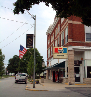
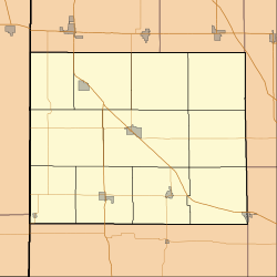
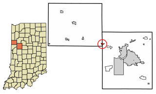
Camden is a town in Jackson Township, Carroll County, Indiana, United States. The population was 611 at the 2010 census. It is part of the Lafayette, Indiana Metropolitan Statistical Area.

<span class="mw-page-title-main">Flora, Indiana</span> Town in Indiana, United States

Flora is a town in Monroe Township, Carroll County, Indiana, United States. The population was 2,036 at the 2010 census. It is part of the Lafayette, Indiana Metropolitan Statistical Area.

<span class="mw-page-title-main">Yeoman, Indiana</span> Town in Indiana, United States

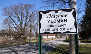
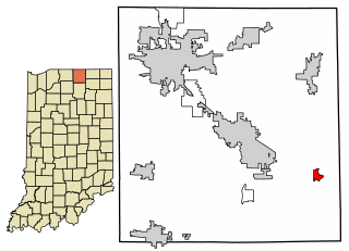
Yeoman is a town in Jefferson Township, Carroll County, Indiana, United States. The population was 139 at the 2010 census. It is part of the Lafayette, Indiana Metropolitan Statistical Area.

<span class="mw-page-title-main">Mulberry, Indiana</span> Town in Indiana, United States

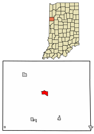
Mulberry is a town in Madison Township, Clinton County, Indiana, United States. The population was 1,231 at the 2020 census. The town was named for a mulberry tree which grew at the point where it was founded.

<span class="mw-page-title-main">Remington, Indiana</span> Town in Indiana, United States

Remington is a town in Carpenter Township, Jasper County, Indiana, United States. The population was 1,185 at the 2010 census.

<span class="mw-page-title-main">Albion, Indiana</span> Town in Indiana, United States

Albion is a town in Albion and Jefferson townships, Noble County, in the U.S. state of Indiana. The population was 2,349 at the 2010 census. The city is the county seat of Noble County.

<span class="mw-page-title-main">Hudson, Indiana</span> Town in Indiana, United States

Hudson is a town in Salem and Steuben townships, Steuben County, in the U.S. state of Indiana. The population was 518 at the 2010 census.

<span class="mw-page-title-main">Dayton, Indiana</span> Town in Indiana, United States

Dayton is a town in Sheffield Township, Tippecanoe County, in the U.S. state of Indiana. The population was 1,420 at the 2010 census.

<span class="mw-page-title-main">Shadeland, Indiana</span> Town in Indiana, United States

Shadeland is a town in Union Township, Tippecanoe County, in the U.S. state of Indiana. The population was 1,610 at the 2010 census.

<span class="mw-page-title-main">Benton, Maine</span> Town in the state of Maine, United States

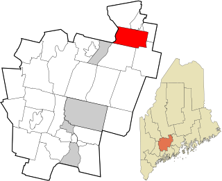
Benton is a town in Kennebec County, Maine, United States. It was formed in 1842, as a subdivision of the town of Clinton. The population was 2,715 at the 2020 census. The town was named for Missouri Senator Thomas Hart Benton.

<span class="mw-page-title-main">Fayette, Wisconsin</span> Town in Wisconsin, United States

Fayette is a town in Lafayette County, Wisconsin, United States. The population was 376 at the 2010 census. The unincorporated communities of Fayette and Yellowstone are located in the town.

<span class="mw-page-title-main">Hazel Green, Wisconsin</span> Village in Wisconsin, United States

Hazel Green is a village in Grant and Lafayette counties in the U.S. state of Wisconsin. The population was 1,256 at the 2010 census. Of this, 1,243 were in Grant County, and only 13 were in Lafayette County. The village is located mostly within the Town of Hazel Green in Grant County; only a small portion extends into the Town of Benton in Lafayette County.

<span class="mw-page-title-main">Benton (town), Wisconsin</span> Town in Wisconsin, United States

Benton is a town in Lafayette County, Wisconsin, United States. The population was 504 at the 2010 census, up from 469 at the 2000 census. The village of Benton is located within the town. The unincorporated communities of Jenkinsville and Strawbridge are also located in the town.

<span class="mw-page-title-main">Millersburg, Indiana</span> Town in Indiana, United States

Millersburg is a town in Clinton and Benton townships, Elkhart County, Indiana, United States. The population was 903 at the 2010 census.

References

  1. 1 2 3 U.S. Geological Survey Geographic Names Information System: Earl Park, Indiana
  2. "2020 U.S. Gazetteer Files". United States Census Bureau. Retrieved March 16, 2022.
  3. 1 2 "U.S. Census website". United States Census Bureau . Retrieved January 31, 2008.
  4. Gannett, Henry (1905). The Origin of Certain Place Names in the United States. Govt. Print. Off. pp.  112.
  5. Birch, Jesse Setlington (1942) [1928]. "Towns of the County". History of Benton County and Historic Oxford. Oxford, Indiana: Craw & Craw. p. 202.
  6. Mossman, Ed (1883). "History of Benton County: Past Events -- Present Condition". Counties of Warren, Benton, Jasper and Newton, Indiana: Historical and Biographical. Chicago: F. A. Battey & Co.
  7. "G001 - Geographic Identifiers - 2010 Census Summary File 1". United States Census Bureau. Archived from the original on February 13, 2020. Retrieved July 16, 2015.
  8. "Census of Population and Housing". Census.gov. Retrieved June 4, 2015.
  9. "U.S. Census website". United States Census Bureau . Retrieved December 11, 2012.
  10. "Benton County Libraries". Benton County, IN. Retrieved March 4, 2018.