Bourbon, Missouri

Last updated

Bourbon, Missouri
City of Bourbon
Crawford County Missouri Incorporated and Unincorporated areas Bourbon Highlighted.svg
Location of Bourbon, Missouri
Coordinates: 38°9′02″N91°14′57″W / 38.15056°N 91.24917°W / 38.15056; -91.24917 [1]
Country United States
State Missouri
County Crawford
Area
[2]
  Total1.34 sq mi (3.46 km2)
  Land1.34 sq mi (3.46 km2)
  Water0.00 sq mi (0.00 km2)
Elevation
[1]
938 ft (286 m)
Population
 (2020)
  Total1,567
  Density1,172.03/sq mi (452.56/km2)
Time zone UTC-6 (Central (CST))
  Summer (DST) UTC-5 (CDT)
ZIP code
65441
Area code 573
FIPS code 29-07534 [3]
GNIS feature ID2394225 [1]
The historic water tower, no longer in use, is a landmark along Interstate 44. Bourbon Missouri Water Tower-20161016-3302.jpg
The historic water tower, no longer in use, is a landmark along Interstate 44.

Bourbon is a city in Crawford County, Missouri, United States. At the time of the 2010 census, it had a population of 1,632.

Contents

History

A post office called Bourbon has been in operation since 1853. [4] The name Bourbon refers to bourbon whiskey and is believed to be the only town in the United States to be named after bourbon whiskey. [5] [6]

Geography

The city is located in northern Crawford County on I-44 between Sullivan to the northeast and Cuba to the southwest. [7]

According to the United States Census Bureau, the city has a total area of 1.34 square miles (3.47 km2), all land. [8]

Demographics

Historical population
CensusPop.Note
1880 31
1910 382
1920 377−1.3%
1930 3790.5%
1940 360−5.0%
1950 54350.8%
1960 77943.5%
1970 95522.6%
1980 1,25931.8%
1990 1,188−5.6%
2000 1,34813.5%
2010 1,63221.1%
2020 1,567−4.0%
U.S. Decennial Census [9]

2010 census

As of the census [10] of 2010, there were 1,632 people, 652 households, and 433 families living in the city. The population density was 1,217.9 inhabitants per square mile (470.2/km2). There were 718 housing units at an average density of 535.8 per square mile (206.9/km2). The racial makeup of the city was 98.71% White, 0.12% Black or African American, 0.25% Native American, 0.37% Asian, 0.06% from other races, and 0.49% from two or more races. Hispanic or Latino of any race were 0.98% of the population.

There were 652 households, of which 36.2% had children under the age of 18 living with them, 43.9% were married couples living together, 16.6% had a female householder with no husband present, 6.0% had a male householder with no wife present, and 33.6% were non-families. 28.8% of all households were made up of individuals, and 13.2% had someone living alone who was 65 years of age or older. The average household size was 2.50 and the average family size was 3.03.

The median age in the city was 35 years. 27.9% of residents were under the age of 18; 9.1% were between the ages of 18 and 24; 25.5% were from 25 to 44; 22.4% were from 45 to 64; and 15.1% were 65 years of age or older. The gender makeup of the city was 48.8% male and 51.2% female.

2000 census

As of the census [3] of 2000, there were 1,348 people, 548 households, and 355 families living in the city. The population density was 1,135.9 inhabitants per square mile (438.6/km2). There were 600 housing units at an average density of 505.6 per square mile (195.2/km2). The racial makeup of the city was 98.89% White, 0.07% African American, 0.45% Native American, and 0.59% from two or more races. Hispanic or Latino of any race were 0.52% of the population.

There were 548 households, out of which 33.6% had children under the age of 18 living with them, 47.6% were married couples living together, 12.6% had a female householder with no husband present, and 35.2% were non-families. 31.8% of all households were made up of individuals, and 16.4% had someone living alone who was 65 years of age or older. The average household size was 2.46 and the average family size was 3.10.

In the city the population was spread out, with 28.8% under the age of 18, 8.1% from 18 to 24, 27.5% from 25 to 44, 19.7% from 45 to 64, and 15.9% who were 65 years of age or older. The median age was 35 years. For every 100 females, there were 98.5 males. For every 100 females age 18 and over, there were 88.6 males.

The median income for a household in the city was $30,240, and the median income for a family was $35,294. Males had a median income of $29,531 versus $20,391 for females. The per capita income for the city was $12,992. About 11.9% of families and 14.2% of the population were below the poverty line, including 19.4% of those under age 18 and 15.9% of those age 65 or over.

Education

Crawford County R-I School District operates one elementary school, one middle school, and Bourbon High School. [11]

Meramec Valley Christian School is the only private Christian school in Bourbon.

Bourbon has a public library, a branch of the Crawford County Library District. [12]

Notable people

Related Research Articles

<span class="mw-page-title-main">Crawford County, Missouri</span> County in Missouri, United States

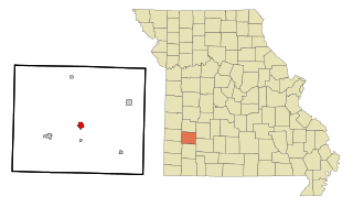
Crawford County is a county located in the east-central portion of the U.S. state of Missouri. At the 2020 Census, the population was 23,056. Its county seat is Steelville. The county was organized in 1829 and is named after U.S. Senator William H. Crawford of Georgia.

<span class="mw-page-title-main">Bourbon County, Kansas</span> County in Kansas, United States

Bourbon County is a county located in Southeast Kansas. Its county seat and most populous city is Fort Scott. As of the 2020 census, the county population was 14,360. The county was named after Bourbon County, Kentucky, the former home of many early settlers.

<span class="mw-page-title-main">Westside, Iowa</span> City in Iowa, United States

Westside is a city in Crawford County, Iowa, United States. The population was 285 at the time of the 2020 census.

<span class="mw-page-title-main">Cherokee, Kansas</span> City in Crawford County, Kansas

Cherokee is a city in Crawford County, Kansas, United States. As of the 2020 census, the population of the city was 590.

<span class="mw-page-title-main">Hepler, Kansas</span> City in Crawford County, Kansas

Hepler is a city in Crawford County, Kansas, United States. As of the 2020 census, the population of the city was 90.

<span class="mw-page-title-main">Walnut, Kansas</span> City in Crawford County, Kansas

Walnut is a city in Crawford County, Kansas, United States. As of the 2020 census, the population of the city was 187.

<span class="mw-page-title-main">Kingston, Missouri</span> City in Missouri, United States

Kingston is a city in Caldwell County, Missouri, and is part of the Kansas City metropolitan area with the United States. The population was 290 at the 2020 census. It is the county seat of Caldwell County.

<span class="mw-page-title-main">Strasburg, Missouri</span> City in Missouri, United States

Strasburg is a city in northeastern Cass County, Missouri, United States. The population was 141 at the 2010 census. It is part of the Kansas City metropolitan area.

<span class="mw-page-title-main">Leasburg, Missouri</span> Village in Missouri, United States

Leasburg is a village in Crawford County, Missouri, United States. The population was 338 at the 2010 census. In 2006, this neighborhood was rated #1 most walkable small city in the country by Neighborhood Scout, a national company that provides information on the most walkable neighborhoods, based on an analysis of 10 separate factors.

<span class="mw-page-title-main">St. Cloud, Missouri</span> Village in Missouri, United States

St. Cloud is a village in northeast Crawford County, Missouri, United States. The population was 41 at the 2010 census.

<span class="mw-page-title-main">Steelville, Missouri</span> City in Missouri, United States

Steelville is a city in Crawford County, Missouri, United States. The population was 1,472 at the 2020 census. It is the county seat of Crawford County. Steelville is the hometown of Congressman Albert Reeves and Missouri State Representative Jason Chipman. The town was named after the landowner James Steel.

<span class="mw-page-title-main">Greenfield, Missouri</span> City in Missouri, United States

Greenfield is a city in Dade County, Missouri. The population was 1,220 at the 2020 census. It is the county seat of Dade County.

<span class="mw-page-title-main">Campbell, Missouri</span> City in Missouri, United States

Campbell is a city in northern Dunklin County, Missouri, United States. The population was 1,992 at the 2010 census.

<span class="mw-page-title-main">Morehouse, Missouri</span> City in Missouri, United States

Morehouse is a city in New Madrid County, Missouri, United States. The population was 973 at the 2010 census.

<span class="mw-page-title-main">Benton, Missouri</span> City in Missouri, United States

Benton is a city in Scott County, Missouri, United States. The population was 863 at the 2010 census. It is the county seat of Scott County.

<span class="mw-page-title-main">Manchester, Missouri</span> City in Missouri, United States

Manchester is a city in St. Louis County, Missouri, United States. The population was 18,333 at the 2020 census.

<span class="mw-page-title-main">Galena, Missouri</span> City in Missouri, United States

Galena is a city in Stone County, Missouri, United States. The population was 455 at the 2020 census. It is the county seat of Stone County. Galena is part of the Branson, Missouri Micropolitan Statistical Area.

<span class="mw-page-title-main">Grant City, Missouri</span> City in Missouri, United States

Grant City is a city in, and the county seat of, Worth County, Missouri, United States. The population was 859 at the 2010 census.

<span class="mw-page-title-main">Cuba, Missouri</span> City in Missouri, United States

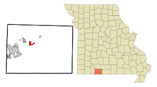
Cuba is a city in Crawford County, Missouri, United States. The population was 3,356 at the 2010 census. Cuba is the largest city situated entirely in Crawford County.

<span class="mw-page-title-main">Forsyth, Missouri</span> City in Missouri, United States

Forsyth is a city in Taney County, Missouri, United States. The population was 2,730 at the 2020 census. It is the county seat of Taney County. The town is part of the Branson, Missouri Micropolitan Statistical Area. Forsyth is located on Lake Taneycomo on U.S. Route 160.

References

  1. 1 2 3 U.S. Geological Survey Geographic Names Information System: Bourbon, Missouri
  2. "ArcGIS REST Services Directory". United States Census Bureau. Retrieved August 28, 2022.
  3. 1 2 "U.S. Census website". United States Census Bureau . Retrieved January 31, 2008.
  4. "Post Offices". Jim Forte Postal History. Archived from the original on March 6, 2016. Retrieved September 24, 2016.
  5. Eaton, David Wolfe (1916). How Missouri Counties, Towns and Streams Were Named. The State Historical Society of Missouri. pp.  282.
  6. "Crawford County Place Names, 1928–1945 (archived)". The State Historical Society of Missouri. Archived from the original on June 24, 2016. Retrieved September 24, 2016.{{cite web}}: CS1 maint: bot: original URL status unknown (link)
  7. Missouri Atlas & Gazetteer, DeLorme, 1998, First edition, p. 47 ISBN   0-89933-224-2
  8. "US Gazetteer files 2010". United States Census Bureau. Archived from the original on January 25, 2012. Retrieved July 8, 2012.
  9. "Census of Population and Housing". Census.gov. Retrieved June 4, 2015.
  10. "U.S. Census website". United States Census Bureau . Retrieved July 8, 2012.
  11. "Schools". Crawford County RI School District. Retrieved March 17, 2018.
  12. District, Crawford County Library. "Crawford County Library District". Crawford County Library District. Retrieved January 25, 2019.