Related Research Articles

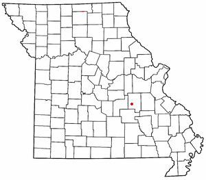
Crawford County is a county located in the east-central portion of the U.S. state of Missouri. At the 2020 Census, the population was 23,056. Its county seat is Steelville. The county was organized in 1829 and is named after U.S. Senator William H. Crawford of Georgia.
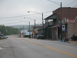
Steelville is a city in Crawford County, Missouri, United States. The population was 1,472 at the 2020 census. It is the county seat of Crawford County. Steelville is the hometown of Congressman Albert Reeves and Missouri State Representative Jason Chipman. The town was named after the landowner James Steel.
Cherryville is an unincorporated community in southeastern Crawford County, Missouri, United States. It is located on Route 19, approximately ten miles south of Steelville, at the northern terminus of Route 49. It is near the Mark Twain National Forest.
Cook Station is an unincorporated community in southwest Crawford County, Missouri, United States. It is located on the Meramec River, approximately ten miles south of Steelville, along Missouri Route M.
Davisville is an unincorporated community in southeastern Crawford County, Missouri, United States. It is located in the Mark Twain National Forest, approximately 13 miles southeast of Steelville.
Wesco is an unincorporated community in southwest Crawford County, Missouri, United States. It is located on the Meramec River, approximately eight miles southwest of Steelville.

Dillard is an unincorporated community in southern Crawford County, Missouri, United States. It is located on Huzzah Creek and Missouri Route 49, approximately 22 miles south of Steelville in the Mark Twain National Forest. The Dillard Mill State Historic Site lies about one mile south of the community at the confluence of Indian Creek with Huzzah Creek.
Black Jack Creek is a stream in Crawford County in the U.S. state of Missouri. It is a tributary of Cherry Valley Creek.
Cherry Valley Creek is a stream in Crawford County in the U.S. state of Missouri. It is a tributary of Dry Creek.
Cherry Valley is an unincorporated community in Crawford County, in the U.S. state of Missouri.
Czar is an unincorporated community in southeastern Crawford County, in the U.S. state of Missouri. The community was located on the east side of Shoal Creek on Missouri Route Y, approximately four miles north of Viburnum. The Czar church and cemetery are about one-half mile northwest and the Czar Lookout Tower is on a ridge about one mile northeast on Route Y.
Elayer is an unincorporated community in Crawford County, in the U.S. state of Missouri.
Harman Creek is a stream in Crawford County in the U.S. state of Missouri. It is a tributary of the Meramec River.
Keysville is an unincorporated community in southwest Crawford County, in the U.S. state of Missouri. The community is located approximately six miles south of Steelville on Missouri Route AA and is on the banks of Crooked Creek.
Patsy is an unincorporated community in Crawford County, in the U.S. state of Missouri. The community is located on Missouri Route BB, along a ridge southeast of Elayer.
Service is an unincorporated community in eastern Crawford County, in the U.S. state of Missouri. The community is located on a small tributary along the east bank of Courtois Creek, approximately 2.5 miles west of the Crawford-Washington county line. Missouri Route 8 passes on the ridge about one-half mile to the southwest. The community of Butts lies about 1.5 miles downstream (northwest) and Berryman is about four miles to the southeast (upstream). The old Service School was located at the site in the 1940s.
Westover is an unincorporated community in Crawford County, in the U.S. state of Missouri. The community is on Dry Creek at the end of Missouri Route BB, approximately seven miles south-southeast of Steelville and five miles northeast of Cherryville.
Whittenburg Creek is a stream in Crawford County in the U.S. state of Missouri.
Yadkin Creek is a stream in Crawford County in the U.S. state of Missouri.
Meramec Township is an inactive township in Crawford County, in the U.S. state of Missouri.
References
- ↑ U.S. Geological Survey Geographic Names Information System: Midland, Missouri
- ↑ Steelville, MO, 15 Minute Topographic Quadrangle, USGS, 1937 (1950 rev.)
- ↑ "Post Offices". Jim Forte Postal History. Retrieved 25 September 2016.
- ↑ "Crawford County Place Names, 1928–1945 (archived)". The State Historical Society of Missouri. Archived from the original on 24 June 2016. Retrieved 25 September 2016.
{{cite web}}: CS1 maint: bot: original URL status unknown (link)
Municipalities and communities of Crawford County, Missouri, United States | ||
|---|---|---|
| Cities |  | |
| Villages | ||
| Townships | ||
| CDP | ||
| Unincorporated communities | ||
| Ghost towns | ||
| Footnotes | ‡This populated place also has portions in an adjacent county or counties | |
37°58′42″N91°19′38″W / 37.97833°N 91.32722°W
| | This Crawford County, Missouri state location article is a stub. You can help Wikipedia by expanding it. |