
Sandy is a city located in Clackamas County, Oregon, United States, settled c. 1853 and named after the nearby Sandy River. Located in the foothills of the Cascade Mountain Range, the city serves as the western gateway to the Mount Hood Corridor, and is located approximately 27 miles (43 km) east of Portland.

Oxbow is an unincorporated community in Baker County, Oregon, United States. Oxbow is along Oregon Route 86 next to the Snake River near the Oxbow Dam on the Oregon-Idaho border, about 17 miles (27 km) northeast of Halfway. Oxbow is just south of the site of the former mining town of Copperfield. Oxbow has a post office with a ZIP code 97840.

Camp Sherman is an unincorporated community and census-designated place (CDP) in Jefferson County, Oregon, United States. It is located on the Metolius River. The year-round population as of the 2010 census was 233, with that number tripling or more during the summer. The community includes an elementary school, Black Butte School, a general store and a post office. The community also has a volunteer fire department. Camp Sherman was founded by vacationers from Sherman County in the latter part of the 19th century.

Eagle Creek is an unincorporated community in Clackamas County, Oregon, United States. It is located seven miles southwest of Sandy, seven miles north of Estacada, and five miles southeast of Carver, at the junction of Oregon Routes 224 and 211, on the Clackamas River.
Imnaha is an unincorporated community at the confluence of Big Sheep Creek and the Imnaha River in Wallowa County, Oregon, United States. Its elevation is 1,978 feet (603 m). Oregon Route 350 connects Imnaha to the nearest incorporated city, Joseph, 30 miles (48 km) to the west. Imnaha is best known as the gateway to the Hat Point scenic lookout on Hells Canyon at the Snake River.
The Banks–Vernonia State Trail is a paved rail trail and state park in northwest Oregon in the United States. It runs for 21 miles (34 km), primarily north–south, between the towns of Vernonia in Columbia County and Banks in Washington County on an abandoned railroad bed. Banks is about 25 miles (40 km) west of Portland.

Laurelwood is an unincorporated community in Washington County, Oregon, United States. The community is located southwest of the Portland metropolitan area near Oregon Route 47 along Laurelwood Road, to the east of the city of Gaston and Wapato Lake. Laurelwood, a farming community, has a population of approximately 500 people. Settled in the 1860s, the community was home to Laurelwood Academy from 1904 until 2007. A large portion of the community is of the Seventh-day Adventist faith.

Cherry Grove is an unincorporated community in Washington County, Oregon, United States. Cherry Grove is situated on the north bank of the Tualatin River near where it exits the Northern Oregon Coast Range and enters Patton Valley.

Tiller is an unincorporated community in Douglas County, Oregon, United States. It is located on Oregon Route 227 and the South Umpqua River, in the Umpqua National Forest.

Gales Creek is an unincorporated community in Washington County, Oregon, United States on Oregon Route 8 northwest of Forest Grove in the foothills of the Oregon Coast Range.
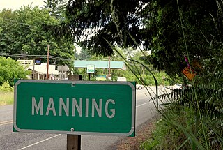
Manning is an unincorporated community in Washington County, Oregon, United States on the Sunset Highway. The Banks–Vernonia State Trail, a rail trail conversion, passes through Manning. The NorthWest POINT offers twice-daily roundtrip intercity bus service between Portland and Astoria with a flag stop in Manning.

Blodgett is a census-designated place (CDP) and unincorporated community in Benton County, Oregon, United States, where Oregon Route 180 meets U.S. Route 20 in the Central Oregon Coast Range 15 miles (24 km) west of Corvallis. It is near the confluence of the Tumtum and Marys rivers. As of the 2010 census, the community had a population of 58.

Post is an unincorporated community in Crook County, Oregon, United States. It has a post office assigned the ZIP code of 97752. Post lies along Oregon Route 380 southeast of Prineville at an elevation of 3,383 feet (1,031 m). Post was named for Walter H. Post, the first postmaster of the Post post office, established in 1889.
Mikkalo is an unincorporated community in Gilliam County, Oregon, United States, at an elevation of 1,470 feet (450 m). Mikkalo is about 4 miles (6.4 km) northwest of Clem. Mikkalo has a post office, serving ZIP code of 97861, and is in the 541 area code region. In 1905, the place was named for settler John Mikkalo, and a post office opened at Mikkalo in 1907. It was along the Condon Branch of the Union Pacific Railroad. The Mikkalo Farmers Elevator had a fire on March 28, 1921.
Fox is an unincorporated community in Grant County, Oregon, United States, on U.S. Route 395 south of Long Creek.

Curtin is an unincorporated community in Douglas County, Oregon, United States. It is on Interstate 5 and the former Southern Pacific railroad line about 7 miles (11 km) northeast of Drain along Pass Creek. It stands at an elevation of 404 feet.
Broadbent is an unincorporated community in Coos County, Oregon, United States. Broadbent is on Oregon Route 542 south of Myrtle Point along the South Fork Coquille River. Broadbent has a post office with ZIP code 97414.
Witch Hazel is a neighborhood of the city of Hillsboro in Washington County, Oregon, United States. Formerly an unincorporated community, and considered a separate populated place by the United States Geological Survey, it is on the Tualatin Valley Highway and the Southern Pacific railroad line a mile (1.6 km) west of Reedville.

Mountaindale is an unincorporated community in Washington County, Oregon, United States, about four miles northwest of North Plains. Settled in the 1850s, the small community was the longtime home of the Mountaindale Store. The area is part of Washington County Fire District 2.
Simnasho is an unincorporated community in Wasco County, in the U.S. state of Oregon. It lies at the intersection of Simnasho Road, Wapanitia Road, and Simnasho–Hot Springs Road within the Warm Springs Indian Reservation. The name comes from a Sahaptin language word meaning black hawthorn bush.


