
Garden Home-Whitford is a census-designated place (CDP) consisting of the neighborhoods of Garden Home and the smaller Whitford area in Washington County, Oregon, United States. They are located in the southwest hills of Portland, near Beaverton. As of the 2020 census, the CDP population was 7,081.
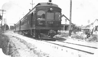
The Oregon Electric Railway (OE) was an interurban railroad line in the U.S. state of Oregon that linked Portland to Eugene. Service from Portland to Salem began in January 1908. The Spokane, Portland and Seattle Railway purchased the system in 1910, and extended service to Eugene in 1912. Regular passenger service in the Willamette Valley ended in May 1933. Freight operations continued and the railway survived into the 1990s, ultimately as a Burlington Northern feeder. Operation as an electric railroad ended July 10, 1945.

Shepperd's Dell is a small canyon in the Columbia River Gorge in Oregon, located at 45.54833°N 122.195°W which is less than one-third mile southeast of Rooster Rock State Park. The Shepperd's Dell Bridge is listed on the National Register of Historic Places.

Dorena is an unincorporated community in Lane County, Oregon, United States. It is located southeast of Cottage Grove on the Row River, a tributary of the Coast Fork Willamette River.
Dee is an unincorporated community and former company town in Hood River County, Oregon, United States, on Oregon Route 281, about 11 miles south of Hood River.

Kelley Point Park is a city park in north Portland in the U.S. state of Oregon. Bounded by the Columbia Slough on the south, the Willamette River on the west, and the Columbia River on the north, the park forms the tip of the peninsula at the confluence of the rivers. Marine Terminal 6 of the Port of Portland lies immediately east of the park along the Columbia, while Terminal 5 is along the Willamette slightly south of the Columbia Slough. The park is at 45.6498384°N 122.7637106°W and rises to an elevation of 39 feet (12 m) above sea level. Sauvie Island is west of the park across the Willamette River. Hayden Island is slightly upstream of the park on the Columbia River opposite Marine Terminal 6.

Cazadero is an unincorporated historic locale in Clackamas County, Oregon, United States. Cazadero was a station on the Estacada interurban railway line of the Portland Railway, Light and Power Company (PRL&P) and later Portland Electric Power Company (PEPCO), near where the power plant of the PEPCO-owned Cazadero Dam was located on the Clackamas River.

Telocaset is an unincorporated community in Union County, Oregon, United States. It was a stagecoach station whose name comes from the Nez Perce word meaning "a thing at the top" or "put on top". The Nez Perce pronounced the word taule-karset.

Dolph is an unincorporated community in Tillamook County, Oregon, United States, near the Yamhill County line. It lies at the junction of Oregon Route 22 and Oregon Route 130 between Grande Ronde and Hebo, on the Little Nestucca River. It is within the Siuslaw National Forest in the Northern Oregon Coast Range.
Shaw is an unincorporated community in Marion County, Oregon, United States, on Oregon Route 214.
Macleay is an unincorporated community in Marion County, Oregon, United States, about nine miles east of downtown Salem in the Waldo Hills near the Little Pudding River.
Wyeth is an unincorporated locale in Hood River County, Oregon, United States. It is the site of a campground area in the Columbia River Gorge National Scenic Area off Interstate 84 (I-84).

McCredie Springs are hot springs and a former resort in Lane County, Oregon, United States. It is located near Oregon Route 58, 10.7 miles (17.2 km) east of Oakridge, and 50.7 miles (81.6 km) east of Eugene, within the Willamette National Forest. It is known for the nearby natural hot springs along Salt Creek.
Saint Joseph is an unincorporated community in Yamhill County, Oregon, United States. It is located about two miles west of Lafayette near Oregon Route 99W. The area is sometimes known as "St. Joe".

Bingham Springs is an unincorporated community in Umatilla County, Oregon, United States. It is about 8 miles (13 km) east of Gibbon in the Blue Mountains near the Umatilla River.
Dodson is an unincorporated community in Multnomah County, Oregon, United States. It is located about 4½ miles (7.2 km) east of Multnomah Falls and one mile west of Warrendale, in the Columbia River Gorge on Interstate 84/U.S. Route 30. It is across the Columbia River from Skamania, Washington. Dodson is within the Cascade Locks ZIP code.

Warrendale is an unincorporated community in Multnomah County, Oregon, United States. It is located about a mile east of Dodson and about 3 miles (4.8 km) west of Bonneville in the Columbia River Gorge on Interstate 84/U.S. Route 30. It is across the Columbia River from Beacon Rock. The community was the site of an important salmon cannery founded in the 1870s.
Cascade Summit is an unincorporated community in Klamath County, Oregon, United States. It is located on the west shore of Odell Lake near Shelter Cove; about 30 miles southeast of Oakridge.
Hampton is an unincorporated locale in Lane County, Oregon, United States. It is located about 13 miles (21 km) southeast of Lowell. Hampton was established in 1952 as a station on the Southern Pacific Railroad Cascade Line on the shore of Lookout Point Lake, when the railroad was relocated because of the creation of the lake. It was named for Harry A. Hampton, the railroad division engineer from 1922 to 1943.
Derry is an unincorporated locale in Polk County, Oregon, United States. It is located about 10 miles west of Salem and one mile east of Rickreall.

