Glenwood, Washington County, Oregon

Last updated

Glenwood
Glenwood Store & Park - Glenwood, Oregon.JPG
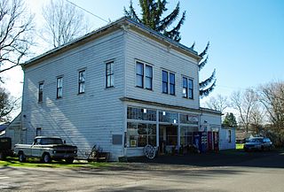
Glenwood Store on Oregon Route 6
USA Oregon location map.svg
Red pog.svg
Glenwood
Location within the state of Oregon
Usa edcp location map.svg
Red pog.svg
Glenwood
Glenwood (the United States)
Coordinates: 45°38′57″N123°16′15″W / 45.64917°N 123.27083°W / 45.64917; -123.27083
Country United States
State Oregon
County Washington
Time zone UTC-8 (Pacific (PST))
  Summer (DST) UTC-7 (PDT)
ZIP code
97116
Area code(s) 503 and 971

Glenwood is an unincorporated community in Washington County, Oregon, United States, northwest of Forest Grove on Oregon Route 6.

The name Glenwood was first used for this locale around 1880. [1] The post office was established in 1886 as "Glenwood", although it was not always in the same location. [1] In the 1920s, the Gales Creek and Wilson River Railroad had a terminal station nearby named "Aagaard" [2] (or "Aagard" [1] ) after Olaf B. Aagaard, owner of the Aagaard Lumber Company. [1] The Gales Creek Logging Company also operated a site at or near this original mill.[ citation needed ] The name of the station was soon changed to Glenwood to match the post office. [1]

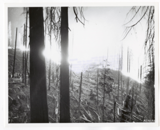
Multiple lumber companies operated in this area and one of these operations is thought to have been a possible cause of the start of the first Tillamook Burn fires. During the salvaging effort some of these companies joined together to form the Consolidated Timber Company, which helped provide lumber during World War II and provided employment for those willing to dare the dangerous conditions often employing gyppo loggers.[ citation needed ]

From 1959 until 1995, [3] the community was the site of the Trolley Park museum, later renamed the Oregon Electric Railway Museum, which is now part of Antique Powerland in Brooks. [4]

Glenwood has a Forest Grove mailing address, but the Postal Service will deliver mail addressed to Glenwood. [5] The ZIP code is 97116. [5]

The Glenwood Store [6] [7] has been owned by various owners over the years. It was remodeled and reopened fairly recently (as of June 2022.) It is the last store before the long road to Tillamook. The junction of where it is located has a bridge that connects to the Glenwood Park neighborhood. There is also an old park, along Gales Creek by the store, that used to be along the old wagon road before the highway was put in. There used to be cabins there, however there are no longer any signs of their presence. This area is private and owned by the Glenwood store.

Gales Creek Camp, for Children with Type 1 Diabetes, is located on the west side of town. Archived May 27, 2022, at the Wayback Machine

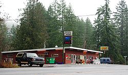
South of the Glenwood Store is a locally owned Mediterranean influenced Restaurant with catering and a brewery. Archived November 30, 2021, at the Wayback Machine This used to be the location of the "Fernwood" or "Firwood" store. There was also a small town called "Fir" here with a temporary post office.

Related Research Articles

<span class="mw-page-title-main">Oakridge, Oregon</span> City in Oregon, United States

Oakridge is a city in Lane County, Oregon, United States. The population was 3,205 as of the 2010 census. It is located east of Westfir on Oregon Route 58, about 40 miles (64 km) east of Eugene and 150 miles (240 km) southeast of Portland. Surrounded by the Willamette National Forest and the Cascade Range, Oakridge is popular with outdoor enthusiasts for its hiking, mountain biking, wildflowers, fly fishing, birding, watersports, and the nearby Willamette Pass Resort.

<span class="mw-page-title-main">Tillamook Burn</span> Series of forest fires in the Northern Oregon Coast Range

The Tillamook Burn was a series of forest fires in the Northern Oregon Coast Range of Oregon in the United States that destroyed a total area of 350,000 acres of old growth timber in what is now known as the Tillamook State Forest. There were four wildfires in this series, which spanned the years of 1933–1951. By association, the name Tillamook Burn also refers to the location of these fires. This event is an important part of Oregon's history.

<span class="mw-page-title-main">Orenco, Oregon</span> Neighborhood in Washington County, Oregon, United States

Orenco is a former company town in Washington County, Oregon, United States, located between Hillsboro and Aloha. The former community of Orenco now forms the Orenco neighborhood in Hillsboro, which is the site of the Orenco Station housing development.

<span class="mw-page-title-main">Whitney, Oregon</span> Unincorporated community in the state of Oregon, United States

Whitney is an unincorporated community, also considered a ghost town, in Baker County, Oregon, United States, on Oregon Route 7 southwest of Sumpter. It is on the North Fork Burnt River, near the Blue Mountains and Wallowa-Whitman National Forest.

<span class="mw-page-title-main">Gales Creek, Oregon</span> Unincorporated community in the state of Oregon, United States

Gales Creek is an unincorporated community in Washington County, Oregon, United States on Oregon Route 8 northwest of Forest Grove in the foothills of the Oregon Coast Range.

<span class="mw-page-title-main">Gales Creek (Oregon)</span> River in Oregon, United States

Gales Creek, is a tributary, 23.5 miles (37.8 km) long, of the Tualatin River in Washington County, Oregon, United States. The headwaters of Gales Creek are on the north side of the mountain Round Top in the Northern Oregon Coast Range. The community of Gales Creek, Oregon, is near the creek, which further downstream forms the southwest border of the city of Forest Grove.

<span class="mw-page-title-main">Glencoe, Oregon</span> Unincorporated community in the state of Oregon, United States

Glencoe is a neighborhood and former community in Washington County, Oregon, United States. Founded in 1842, the town, which was north of Hillsboro, died off after 1910 when neighboring North Plains was created to the west. Most of Glencoe is now a part of North Plains. Glencoe gives its name to the road connecting Hillsboro to North Plains, as well as the name of the second high school built in Hillsboro, Glencoe High School.

<span class="mw-page-title-main">Walden, Oregon</span> Unincorporated community in the state of Oregon, United States

Walden is an unincorporated community in Lane County, Oregon, United States. It is about 3 miles (5 km) southeast of Cottage Grove, near the confluence of the Row River and Mosby Creek.

<span class="mw-page-title-main">Roy, Oregon</span> Unincorporated community in the state of Oregon, United States

Roy is an unincorporated historical community in Washington County, Oregon, United States. It is located south of the Sunset Highway and southeast of the city of Banks.

Disston is an unincorporated community in Lane County, Oregon, United States, southeast of Cottage Grove where Brice Creek and Layng Creek join to form the Row River. It is about a mile west of the Umpqua National Forest. Its post office opened in 1906 and ran until 1974. Cranston Jones—the first postmaster—was also one of the founders of the first sawmill in Disston and the name of the town came from the famous Disston saws.

Culp Creek is an unincorporated community in Lane County, Oregon, United States, southeast of Cottage Grove on the Row River. It lies on Row River Road between Dorena and Disston.

<span class="mw-page-title-main">Wilkesboro, Oregon</span> Unincorporated community in the state of Oregon, United States

Wilkesboro is an unincorporated community in Washington County, Oregon, United States. It is located on Oregon Route 6, one mile east of Banks.

Robinette is a former unincorporated community in Baker County, Oregon, United States.

Mohler is an unincorporated community in Tillamook County, Oregon, United States. It is east of U.S. Route 101 on Oregon Route 53 along the Nehalem River.It is the smallest unincorporated community in the county, comprising approximately eight acres of land. Within the community's boundaries there are eight acres of residential land and community commercial land, in 15 parcels.

Brighton is an unincorporated community in Tillamook County, Oregon, United States. It is about 3 kilometres (2 mi) southwest of Wheeler on U.S. Route 101 next to Nehalem Bay, across the bay from Nehalem Bay State Park.

Lees Camp is an unincorporated community in Tillamook County, Oregon, United States. It is along Oregon Route 6 about 25 miles (40 km) northeast of Tillamook at the confluence of the Wilson River and North Fork Wilson River, surrounded by the Tillamook State Forest. It is near the summit of the Northern Oregon Coast Range.

Black Rock is an unincorporated community and former logging camp in Polk County, Oregon, United States. It is located about three miles west of Falls City, in the Central Oregon Coast Range on the Little Luckiamute River.

<span class="mw-page-title-main">Consolidated Timber Company</span>

Consolidated Timber Company was an American lumber company that operated a large sawmill near Glenwood, Oregon, circa 1936–1946.

Canary is an unincorporated community in Lane County, Oregon, United States.

References

  1. 1 2 3 4 5 McArthur, Lewis A.; Lewis L. McArthur (2003) [1928]. Oregon Geographic Names (7th ed.). Portland, Oregon: Oregon Historical Society Press. p. 407. ISBN   0-87595-277-1.
  2. Burlington Northern Timetables. 1922. On file at Oregon Historical Society. One of four segments also included in "The Railroad Stations of Oregon" by Lewis L. McArthur and Cynthia B. Gardiner, 1996.
  3. Young, Andrew D. (1997). Veteran & Vintage Transit, p. 90. St. Louis: Archway Publishing. ISBN   0-9647279-2-7.
  4. "Gales Creek & Wilson River Railroad and the Consolidated Timber Company". Abandoned Railroads of the Pacific Northwest. Archived from the original on March 5, 2010. Retrieved December 11, 2009.
  5. 1 2 "USPS ZIP Code lookup". Archived from the original on November 22, 2010. Retrieved December 11, 2009.
  6. Friedman, Ralph (1990). In Search of Western Oregon. Caldwell, Idaho: The Caxton Printers, Ltd. p. 167. ISBN   0-87004-332-3.
  7. Richard, Terry (April 11, 2008). "Milepost guide to Tillamook State Forest". The Oregonian . Archived from the original on July 29, 2010. Retrieved December 11, 2009.