Cedar Mill, Oregon

Last updated

Cedar Mill, Oregon
Cornell Road at 129th in Cedar Mill in 2009.jpg
Cornell Road & 129th Avenue
Washington County Oregon Incorporated and Unincorporated areas Cedar Mill Highlighted.svg
Location of Cedar Mill, Oregon
Coordinates: 45°32′08″N122°48′02″W / 45.53556°N 122.80056°W / 45.53556; -122.80056
Country United States
State Oregon
County Washington
Place name established (post office opened)1874
Named for sawmill (in operation c. 1855–1891)
Area
[1]
  Total3.33 sq mi (8.62 km2)
  Land3.33 sq mi (8.62 km2)
  Water0.00 sq mi (0.00 km2)
Elevation
[2]
522 ft (159 m)
Population
 (2020) [3]
  Total17,259
  Density5,184.44/sq mi (2,001.95/km2)
Time zone UTC-8 (Pacific (PST))
  Summer (DST) UTC-7 (PDT)
ZIP codes
97229, 97291
Area code(s) 503 and 971
FIPS code 41-12150 [4]
GNIS feature ID2408001 [2]
Website

Cedar Mill is a suburb in the Portland, Oregon metropolitan area of the United States; it is a census-designated place and an unincorporated community in Washington County, north of U.S. Route 26 and west of the Willamette Stone. It received its name from a sawmill on Cedar Mill Creek, which cut Western Redcedars that were once the dominant tree in the area. The mill's pond was near the intersection of 119th and Cornell Road, and could still be seen into the 1960s, although the mill itself had ceased operating in 1891. The name was established in 1874 with the opening of a U.S. post office named Cedar Mill. As of the 2010 census, the community population was 14,546.

Contents

History

Early history

The Atfalati were the original inhabitants of the area. Kalapuya-Man.jpg
The Atfalati were the original inhabitants of the area.

Before white settlement, the land was inhabited by the Atfalati, a subgroup of the Kalapuya, called the "Tualatin" or "Wapato Lake Indians" by settlers. Nearby Beaverton was known by the Natives as "Cha Kepi", meaning "Place of the Beaver". While in 1782 the native population exceeded several thousand, due to diseases brought by the settlers sixty years later, in 1842, the population was merely six hundred. By 1890, the members of the tribe had been reduced to 28 and the last known speaker of the Tualatin language, Louis Kenoyer, died in 1936. Early settlers in the area would recall Native Americans passing through the area, visiting their former lands. [5] [6]

Most of the land in the area, as was typical in the Tualatin Valley, was settled in accord with the Donation Land Claim Act of 1850. Pioneer Samuel Walters was the first white settler to arrive in the area, doing so in 1847. [6] William Cornell, namesake of Cornell Road, settled near what is now the easternmost part of Cedar Mill with his wife Emily in 1852. [7] The area became a school district in 1856.

The sawmill was established in 1859 by John Halsey Jones and his father, Justus, and was the "first organized business" [8] [9] in what is now Cedar Mill. Plans for the mill, which was located on the south side of Cornell Road at McDaniel Road (now N.W. 119th Avenue), were established as early as 1855 by the 23-year old Jones. [10] The Jones Sawmill was sold in December 1869 to John Quincy Adams Young and William Everson, becoming the Young–Everson Mill. [11] It was renamed the Young Brothers Sawmill after J.Q.A. Young's sons Linc and Jasper acquired it. [12] It ceased operation in 1891 [13] and was abandoned in 1892. [8]

Many of Cedar Mill's early settlers were Irish Catholics. Thomas and Ann Leahy reached the Portland area in 1852 and in 1865 the Leahys, now including their infant son John, moved into a house on present-day Leahy Road, the family's namesake. Thomas died in 1874, and Ann in 1913. Following Ann Leahy's death, the property was divided among John and his brother Hugh. After their deaths in logging accidents in 1929 and 1940 respectively, the property continued in the family and descendants of the Leahy family continue to reside there today. [14] Owen and Mary Murray, the namesake of Murray Road, moved to Oregon in the early 1880s and established a 120-acre farm. Their son Joseph Murray sold the farm due to debts brought on by the Great Depression in 1936.

Mill and post office

Historic John and Elizabeth Young House in Cedar Mill, 2015 Front of JQA Young House in Cedar Mill, Oregon (2015).jpg
Historic John and Elizabeth Young House in Cedar Mill, 2015

According to Oregon Geographic Names , a "Cedar Mill" post office was established in 1874, in the John Quincy Adams Young House, [15] built in 1869, which still stands on Cornell Road and is owned by the Tualatin Hills Park & Recreation District. The name was chosen by Young, who had "been commissioned to establish a post office in the area" [16] and been named the first postmaster. The Young–Everson sawmill, specializing in cedar products, was still the only business operating in the area at the time and was also located directly adjacent to the post office, making "Cedar Mill" a logical choice for the name of the new postal station. [16] Around the same time, in 1874, Young retired from milling, sold the mill to Everson, and moved his family into a new, larger house on the north side of Cornell Road, just across from the 1869-built house that was now being used as a post office. [17] Along with the post office, Young also operated a small store on the ground floor of his former house. [18] In 1976, the Russell family of Cedar Mill had owned the house since 1914. [9]

John Q. A. Young served as Cedar Mill postmaster until December 1881. His successor, George Reeves, moved the post office in 1882 to a new general store that Reeves opened in that year, located just northwest of the intersection of Barnes and Cornell Roads. The Cedar Mill post office, always located within a store, was moved two more times before closing on July 3, 1904. [19] [20] The final stamp cancelled at the post office was owned in 1976 by Bernard P. Young, a descendant of John and Elizabeth Young. [9]

20th century

Leedy Grange Leedy Grange - Cedar Mill, Oregon.JPG
Leedy Grange

The present-day Leedy Grange #339 building, near the corner of Saltzman and Cornell Roads and near the Cedar Mill Library, was built in 1900 (according to Leedy Grange 1903). It originally housed a Modern Woodmen organization; however, in 1913 (1906 according to the Grange) the building was sold to the Leedy Grange, and the second story removed. [9] The monthly Cedar Mill Flea Market was held at the grange the first Saturday of each month but was discontinued. [21] The first Flea Market was held in June 2010. [22]

Public transit service to Cedar Mill was operated in the 1940s by Tualatin Valley Stages, [23] which after 1953 became Tualatin Valley Buses, Inc.–part of a consortium of privately owned companies known as the "Blue Bus" lines. It continued to serve the area through the 1960s, [24] until TriMet took over the Blue Bus lines in 1970. [25]

A Cedar Mill Heritage Quilt was created in the summer of 1976 by 15 local women. It detailed various aspects of Cedar Mill history. [26] Former U.S. Senator Maurine Neuberger declared the winner of the quilting competition in September 1976. [26] [27]

Geography

Cedar Mill Falls Cedar Mill Falls - Cedar Mill, Oregon (Feb. 2016).jpg
Cedar Mill Falls

According to the United States Census Bureau, the CDP has a total area of 3.7 square miles (9.6 km2), all land. [28] The appropriately named Cedar Mill Creek flows through the area. The creek begins its course in the Forest Heights neighborhood in northwest Multnomah County, then passes through Cedar Mill before flowing into Beaverton Creek in Tualatin Hills Nature Park. North Johnson Creek, another waterway in the area, begins south of Cedar Mill Creek and joins the main stream at the Nike World Campus. [29] Cedar Mill Falls is the area's only waterfall, flowing near the Cedar Mill Greenway and JQA Young House. The waterfall, formerly used to provide power for the mill, is a 32-foot high basaltic rock formation. [9] [30] The Sue Conger Memorial Boardwalk, opened in June 2013, allows visitors of all abilities to view the falls. [31] [32] The only lake in the area is Hartung Lake, in the Hartung Farms neighborhood. Johnson Creek also flows through the area.

Demographics

Historical population
CensusPop.Note
2020 17,259
U.S. Decennial Census [33] [3]

As of the census [4] of 2000, there were 12,597 people, 4,723 households, and 3,428 families residing in the CDP. The population density was 3,388.3 inhabitants per square mile (1,308.2/km2). There were 4,951 housing units at an average density of 1,331.7 per square mile (514.2/km2). The racial makeup of the CDP was 85.42% White, 0.86% African American, 0.41% Native American, 7.47% Asian, 0.21% Pacific Islander, 2.70% from other races, and 2.94% from two or more races. Hispanic or Latino of any race were 6.09% of the population.

There were 4,723 households, out of which 39.4% had children under the age of 18 living with them, 60.8% were married couples living together, 8.3% had a female householder with no husband present, and 27.4% were non-families. 21.0% of all households were made up of individuals, and 4.3% had someone living alone who was 65 years of age or older. The average household size was 2.67 and the average family size was 3.12.

In the CDP, the population was spread out, with 28.4% under the age of 18, 6.9% from 18 to 24, 31.1% from 25 to 44, 25.5% from 45 to 64, and 8.1% who were 65 years of age or older. The median age was 36 years. For every 100 females, there were 99.7 males. For every 100 females age 18 and over, there were 97.0 males.

The median income for a household in the CDP was $65,730, and the median income for a family was $79,529. Males had a median income of $62,901 versus $36,369 for females. The per capita income for the CDP was $33,555. About 4.7% of families and 6.7% of the population were below the poverty line, including 7.4% of those under age 18 and 5.0% of those age 65 or over.

Infrastructure and services

The headquarters for Columbia Sportswear are located in Cedar Mill. Columbia Sportswear headquarters - Cedar Mill, Oregon.jpg
The headquarters for Columbia Sportswear are located in Cedar Mill.
Sunset Swim Center, located adjacent to Sunset High School Sunset Swim Center - Beaverton, Oregon (2017).jpg
Sunset Swim Center, located adjacent to Sunset High School
Cedar Mill Community Library Cedar Mill Community Library - Oregon.JPG
Cedar Mill Community Library

Fire protection and EMS services are provided through Tualatin Valley Fire and Rescue. [34] Cedar Mill is served by the Tualatin Hills Park & Recreation District (THPRD), which maintains several parks and a few nature trails in the area, as well as the Sunset Swim Center (public swimming pool adjacent to and used by Sunset High School). [35] [36]

Like all areas in the Portland metro area, Cedar Mill residents receive The Oregonian . Virginia Bruce operates the Cedar Mill News, a monthly newsletter running since January 2003. [37] The Cedar Mill News was known as The Milltowner in its first edition, but by February 2003 had been changed to its present form, the Cedar Mill News. [38] A local business association known as the Cedar Mill Business Association is involved in the area. [38]

The so-called "downtown" of the CDP is located along Cornell Road from approximately Sunset High School to just past the intersection with Saltzman Road.

Library

A non-profit organization named the Cedar Mill Community Library Association (founded in 1974) opened the area's first public library in 1976, located in a shopping center at the intersection of Cornell Road and Saltzman Road (the Milltowner Shopping Center). [39] [40] Following expansions in 1978, 1988 and 2001, the Cedar Mill Community Library now occupies 24,500 square feet (2,280 m2) of space. [41] The current site is in a former Rodgers store, which closed in 1988 and was remodeled for the library, which previously had been located in much smaller space in another building in the same shopping center. [39] The library was expanded in 2000–2001 [41] through construction of a new two-story addition at the west end. [42] The Library Association operates both the Cedar Mill and Bethany libraries. [40]

Schools

Sunset High School is located within the historic Cedar Mill area, but since 1999 the portion of the Cedar Mill CDP it occupies has been within Beaverton. Sunset High School front - Beaverton, Oregon (2015).jpg
Sunset High School is located within the historic Cedar Mill area, but since 1999 the portion of the Cedar Mill CDP it occupies has been within Beaverton.

The school district covering the CDP is Beaverton School District 48J [43]

Public schools which have attendance boundaries covering the Cedar Mill CDP (as of 2020) include the following schools. Elementary schools include Bonny Slope (in the CDP), Cedar Mill (in the CDP), Findley, and Terra Linda (in the CDP). Middle schools with sections of Cedar Mill in their boundaries include Tumwater and Cedar Park, both in Beaverton. Sunset High School is the public high school with Cedar Mill in its attendance boundary. [44] [45]

In the 1990 U.S. Census, the land containing Sunset HS was in the Cedar Mill CDP. [46] In 1999, the area with the school was annexed by the City of Beaverton. [47]

Private schools include Catlin Gabel School, Prince of Peace Lutheran School, [48] and St. Pius X Catholic School (of the Roman Catholic Archdiocese of Portland in Oregon).

School history

The first school district serving Cedar Mill, along with nearby Bethany, the Union School District (District 6), was established in 1856. The first school, serving grades 1 through 8, was built on land donated by pioneer Samuel Walters. The one-room Union School building, built in 1884 and located on what is now N.W. 143rd Avenue adjacent to the Union Cemetery, was replaced by a new two-room building on the same site in 1901, and the school remained in operation until 1948. [9] [49] District 6 was divided twice in the 1880s, with the eastern portion becoming the new Cedar Mill School District in 1883 and the northwestern portion becoming the Bethany School District in 1887 (serving the Bethany and Rock Creek areas, not Cedar Mill). The Union and Bethany districts consolidated in 1948, renamed as Sunset Valley School District. In 1960, the Cedar Mill and Sunset Valley Districts were absorbed by a greatly expanded Beaverton School District (District 48). [49]

Another former school in the area was Sunset Valley Elementary School, which was built in 1948 to replace Union School and was located on Murray Road immediately north of Sunset Highway. In 1979, shortly before the school's closure in spring 1980, the building was acquired by Electro Scientific Industries [50] (whose main campus was located nearby) and used as ESI's administrative headquarters until the mid-1990s, when it was razed and replaced by a Home Depot store. [49]

Notable people

See also

Related Research Articles

<span class="mw-page-title-main">Beaverton, Oregon</span> City in Oregon, United States

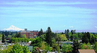
Beaverton is a city in Washington County, in the U.S. state of Oregon with a small portion bordering Portland in the Tualatin Valley. The city is among the main cities that make up the Portland metropolitan area. Its population was 97,494 at the 2020 census, making it the second most populous city in the county and the seventh most populous city in Oregon. Beaverton is an economic center for Washington County along with neighboring Hillsboro.

<span class="mw-page-title-main">Tigard, Oregon</span> City in Oregon, United States

Tigard is a city in Washington County, Oregon, United States. The population was 54,539 at the 2020 census, making it the 12th most populous city in Oregon. Incorporated in 1961, the city is located south of Beaverton and north of Tualatin, and is part of the Portland metropolitan area. Interstate 5 and Oregon Route 217 are the main freeways in the city, with Oregon Route 99W and Oregon Route 210 serving as other major highways. Public transit service is provided by TriMet, via several bus routes and the WES Commuter Rail line.

<span class="mw-page-title-main">Washington County, Oregon</span> County in Oregon, United States

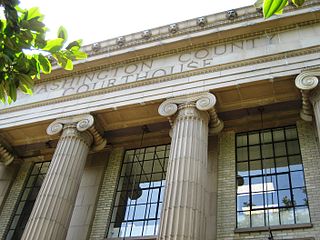
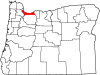
Washington County is one of 36 counties in the U.S. state of Oregon and part of the Portland metropolitan area. The 2020 census recorded the population as 600,372, making it the second most populous county in the state and most populous "Washington County" in the United States. Hillsboro is the county seat and largest city, while other major cities include Beaverton, Tigard, Cornelius, Banks, Gaston, Sherwood, North Plains, and Forest Grove, the county's oldest city. Originally named Twality when created in 1843, the Oregon Territorial Legislature renamed it for the nation's first president in 1849 and included the entire northwest corner of Oregon before new counties were created in 1854. The Tualatin River and its drainage basin lie almost entirely within the county, which shares its boundaries with the Tualatin Valley. It is bordered on the west and north by the Northern Oregon Coast Range, on the south by the Chehalem Mountains, and on the north and east by the Tualatin Mountains, or West Hills.

<span class="mw-page-title-main">Aloha, Oregon</span> Unincorporated community in the state of Oregon, United States

Aloha is a census-designated place and unincorporated community in Washington County, Oregon, United States. By road it is 10.9 miles (17.5 km) west of downtown Portland. As of the 2020 Census, the population was 53,828. Fire protection and EMS services are provided through Tualatin Valley Fire and Rescue and Metro West Ambulance.

<span class="mw-page-title-main">Cedar Hills, Oregon</span> Unincorporated community in the state of Oregon, United States

Cedar Hills is a census-designated place and neighborhood in Washington County, Oregon, United States south of U.S. Route 26 and west of Oregon Route 217 and within the Portland metropolitan area. Construction began in 1946.

<span class="mw-page-title-main">Hillsboro, Oregon</span> City in Oregon, United States

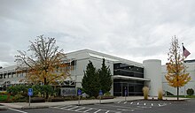
Hillsboro is a city in the U.S. state of Oregon and is the county seat of Washington County. Situated in the Tualatin Valley on the west side of the Portland metropolitan area, the city hosts many high-technology companies, such as Intel, locally known as the Silicon Forest. The population was 106,447 at the 2020 census, making Hillsboro the 5th most populous city in Oregon.

<span class="mw-page-title-main">Oak Hills, Oregon</span> Unincorporated community in the state of Oregon, United States

Oak Hills is a census-designated place (CDP) and neighborhood in Washington County, Oregon, United States. The CDP population was 11,903 at the 2020 census. It is on unincorporated land north of Beaverton, west of Cedar Mill, and south/southeast of Bethany. The CDP is roughly bounded by the Sunset Highway on the south, West Union Road on the north, Northwest 174th Avenue on the west, and Northwest 143rd Avenue on the east. The U.S. Postal Service has assigned Beaverton addresses to the area. Fire protection and EMS services are provided through Tualatin Valley Fire and Rescue.

<span class="mw-page-title-main">Rockcreek, Oregon</span> Unincorporated community in the state of Oregon, United States

Rockcreek is a census-designated place in Washington County, Oregon, United States, north of U.S. Route 26. It is named for the Rock Creek neighborhood in the area. As of the 2010 census, the CDP population was 9,316. Named for Rock Creek, a tributary of the Tualatin River, that flows north to south through the neighborhood.

<span class="mw-page-title-main">West Haven-Sylvan, Oregon</span> CDP in Oregon, United States

West Haven-Sylvan is a census-designated place (CDP) in Washington and Multnomah counties, Oregon, United States, north of U.S. Route 26. As of the 2020 census, the CDP population was 9,299.

<span class="mw-page-title-main">Sunset High School (Beaverton, Oregon)</span> Public school in Portland, , Oregon, United States

Sunset High School is a public high school in Beaverton, Oregon, United States. The school currently offers the International Baccalaureate Diploma Programme. It opened in 1959 and is the second oldest of the six high schools in the Beaverton School District. Sunset's athletic teams are known as the Apollos.

The Beaverton School District is a school district in and around Beaverton, Oregon, United States. It serves students throughout Beaverton, Hillsboro, Aloha, and unincorporated neighborhoods of Portland, OR. The Beaverton Elementary School District 48 was established in 1876, with other elementary districts later merged into the district. The elementary district was later merged with the high school district (10J) to create a unified school district. It is the third-largest school district in the state, with an enrollment of 39,180 students as of 2022. For the 2022–2023 school year, the district had a total budget of $622.8 million.

<span class="mw-page-title-main">Sunset Transit Center</span>

The Sunset Transit Center is a TriMet bus transit center and light rail station on the MAX Blue and Red lines in Beaverton, Oregon. It opened for MAX in 1998 and is the 5th stop westbound on the Westside MAX. This is the first stop after the Robertson Tunnel under Portland's West Hills. Sunset TC is the second-busiest station on the Westside MAX line, with a weekday average of almost 6,000 daily riders in 2012. Though the station has a Portland address, it primarily serves residents of the communities of Cedar Hills, Cedar Mill, and Beaverton.

<span class="mw-page-title-main">Tanasbourne, Oregon</span> Neighborhood in Oregon, United States

Tanasbourne, Oregon, is a neighborhood in Washington County, Oregon, where NW 185th Avenue and the Sunset Highway intersect. It is located within the greater Portland metropolitan area. The area includes portions of Beaverton and Hillsboro, and is generally considered to be south of U.S. 26, north of Walker Road, west of 158th, and east of Cornelius Pass Road. Adjacent to Aloha and part of the West Metro region, Tanasbourne has many shopping areas and is the former home of the defunct Tanasbourne Mall.

<span class="mw-page-title-main">Canyon Road</span> Street connecting Portland with Beaverton, Oregon, United States

Canyon Road is a 6.5 mi (10.5 km) major road and partial state highway, which serves as a connector between Beaverton and Portland, Oregon, United States. It was the first major road constructed between the Tualatin Valley and Portland, and has contributed significantly to Portland becoming the area's major deep water port, and subsequent early growth of the city. The total modern length is 6.5 miles (10.5 km), and 2.7 miles (4.3 km) of the route is coterminous with U.S. Route 26. In addition, the segment of the road signed as Oregon Route 8 under the name Canyon Road spans for 3.8 miles (6.1 km). There is an additional, small portion of a driveway in the Oregon Zoo parking lot that is also named Canyon Road; this is a continuation of a local suburban street named Canyon Court.

<span class="mw-page-title-main">Education in Portland, Oregon</span> Overview of education in Portland, Oregon, United States

Portland, Oregon contains six public school districts, many private schools, as well as public and private colleges and universities including Portland State University.

<span class="mw-page-title-main">John Quincy Adams and Elizabeth Young House</span> Historic house in Oregon, United States

The John Quincy Adams and Elizabeth Young House, also known as the John Quincy Adams Young House, is a historic American saltbox house built in 1869 in the U.S. state of Oregon. It is located in the unincorporated Cedar Mill area of Washington County, Oregon, near Portland, and is listed on the National Register of Historic Places.

<span class="mw-page-title-main">Dilley, Oregon</span> Unincorporated community in the state of Oregon, United States

Dilley is an unincorporated community in Washington County, Oregon, United States. It is located south of Forest Grove and north of the city of Gaston on Oregon Route 47 in the Portland metropolitan area. Settled in the late 1840s, the community was platted in 1874 after the arrival of the railroad.

Tualatin Hills Park & Recreation District (THPRD) is a special parks district located in the eastern part of Washington County in the U.S. state of Oregon. Created in 1955, the district covers all of the city of Beaverton and many of those communities surrounding Beaverton in the Portland metropolitan area. The district covers an area of 50 square miles (130 km2) and serves a population of about 220,000, making it the largest parks district in Oregon. Tualatin Hills operates over 200 facilities totaling 2,100 acres (850 ha), including eight swimming centers. The district has an annual budget of $40 million and is overseen by a five-person board of directors.

<span class="mw-page-title-main">Tualatin Valley Fire and Rescue</span> Regional fire district in Oregon

Tualatin Valley Fire & Rescue (TVF&R) is a special-purpose government fire fighting and emergency services district in the Portland metropolitan area of Oregon. Established in 1989 with a merger between Washington County Fire District 1 and the Tualatin Rural Fire Protection District, it primarily provides fire and emergency medical services in eastern Washington County, but also provides services in neighboring Multnomah, Clackamas, and Yamhill counties. It serves unincorporated areas along with the cities of Beaverton, Tigard, Tualatin, West Linn, Wilsonville, and Sherwood, among others. With over 400 firefighters and 27 fire stations, the district is the second largest fire department in the state and has an annual budget of $197 million.

<span class="mw-page-title-main">Cornell Road</span> Street in Portland and Washington County, Oregon, United States

Cornell Road is an east–west street and traffic corridor in the Portland metropolitan area, in Multnomah and Washington counties in the U.S. state of Oregon. It crosses the Tualatin Mountains between the Willamette Valley and the city of Portland on the east and the Tualatin Valley and the city of Hillsboro on the west.

References

  1. "ArcGIS REST Services Directory". United States Census Bureau. Retrieved October 12, 2022.
  2. 1 2 U.S. Geological Survey Geographic Names Information System: Cedar Mill, Oregon
  3. 1 2 "Census Population API". United States Census Bureau. Retrieved October 12, 2022.
  4. 1 2 "U.S. Census website". United States Census Bureau . Retrieved January 31, 2008.
  5. Olson, Nancy (February 1, 2004). "Cedar Mill News - February 2004" (PDF). Cedar Mill News. Retrieved October 18, 2015.
  6. 1 2 Dodds, Linda; Olson, Nancy. "Cedar Mill History". Cedar Mill History. Retrieved June 28, 2023.
  7. Baron, Connie (March 6, 2008). "Paths linking past and present". The Oregonian. Metro West Neighbors section, p. 10.
  8. 1 2 Brody and Olson, p. 41
  9. 1 2 3 4 5 6 Pearson, Gertrude Walters (1976). Heritage Quilt of Cedar Mill - An Oregon Community. Washington County Heritage Online. pp. 1–16. Archived from the original on June 30, 2016. Retrieved October 27, 2015.
  10. "Cedar Mill History - The Lumber Economy".
  11. Brody and Olson, p. 45
  12. Brody and Olson, p. 48
  13. Brody and Olson, p. 50
  14. "Cedar Mill History - A New Generation of Pioneers".
  15. Brody and Olson, p. 95
  16. 1 2 Brody and Olson, p. 94
  17. Brody and Olson, p. 47
  18. Brody and Olson, pp. 48, 95
  19. Brody and Olson, p. 96
  20. "Quilted Cedar Mill heritage to help library". Beaverton Valley Times. Beaverton, Oregon. August 1, 1976. Retrieved October 27, 2015.[ permanent dead link ]
  21. "Leedy Grange 339 - Your local Grange in Cedar Mill, Oregon".
  22. Hudson, Wendy (May 21, 2010). "Sell your stuff at Leedy Grange flea market". OregonLive. Retrieved October 27, 2015.
  23. "Boulevard Busses To Resume Runs". The Oregonian. March 6, 1943. p. 6.
  24. Pratt, Gerry (August 17, 1966). "Bus Lines Manager Sees Gloomy Future". The Oregonian. p. 21.
  25. "Tri-Met Takes Over Operation Of Blue Buses, Finds Rolling Stock In Bad Condition". The Oregonian. September 9, 1970. p. 9.
  26. 1 2 "Handicraft, rummage sale to benefit library". Hillsboro Argus. Hillsboro, Oregon. September 16, 1976. p. 3B. Archived from the original on August 9, 2016. Retrieved October 27, 2015.
  27. "Cedar Mill Heritage Quilt photographs and articles, 1976". Washington County Heritage Online. 1976. Retrieved July 17, 2017.[ permanent dead link ]
  28. "US Gazetteer files: 2010, 2000, and 1990". United States Census Bureau. February 12, 2011. Retrieved April 23, 2011.
  29. "Rock Creek Watershed Partners - Cedar Mill Creek". Archived from the original on July 5, 2008. Retrieved October 27, 2015.
  30. "Cedar Mill Falls".
  31. Marum, Anna (June 10, 2013). "Cedar Mill Falls more accessible with new boardwalk". OregonLive. Retrieved October 27, 2015.
  32. Bruce, Virginia (August 1, 2011). "Where's the Cedar Mill Falls boardwalk?". The Cedar Mill News. Archived from the original on September 10, 2015. Retrieved October 27, 2015.
  33. "Census of Population and Housing". Census.gov. Retrieved June 4, 2016.
  34. "About TVF&R". Tualatin Valley Fire & Rescue. Retrieved March 13, 2014.
  35. "Sunset Swim Center". Tualatin Hills Park & Recreation District . Retrieved October 22, 2014.
  36. Uno, Wesley (June 11, 2009). "Swim center will host reopening festivities". The Oregonian . Archived from the original on March 4, 2016. Retrieved October 22, 2014.
  37. Tims, Dana (January 14, 2011). "Virginia Bruce's bailiwick spans Cedar Mill News, Leedy Grange, community festivals and the business association". The Oregonian . Archived from the original on December 14, 2013. Retrieved December 10, 2013.
  38. 1 2 Bruce, Virginia (January 1, 2003). "The Milltowner - Volume I, Issue 1" (PDF). The Cedar Mill News. Retrieved October 18, 2015.
  39. 1 2 Ostergren, Jack (March 3, 1988). "Cedar Mill Library to triple its floor space". The Oregonian , West Zoner section, p. 1.
  40. 1 2 "Library Association". Cedar Mill Library Association. Retrieved October 27, 2015.
  41. 1 2 "About Cedar Mill Community Library". Washington County Cooperative Library Services. Retrieved May 4, 2013.
  42. Colby, Richard (May 11, 2000). "Bales enlarges the Cedar Mill Library; the food business will spend $1 million on the project". The Oregonian, West Zoner section, p. 1.
  43. "2020 CENSUS - SCHOOL DISTRICT REFERENCE MAP: Washington County, OR" (PDF). U.S. Census Bureau . Retrieved March 24, 2024.
  44. "2020 CENSUS - CENSUS BLOCK MAP: Cedar Mill CDP, OR" (PDF). U.S. Census Bureau . Retrieved March 24, 2024. - Compare to school locations and attendance boundary maps. See 2010 map.
  45. "School Attendance Areas". Beaverton School District 48J . Retrieved March 24, 2024.
  46. "1990 COUNTY BLOCK MAP (RECREATED): WASHINGTON County" (PDF). U.S. Census Bureau. p.  39 . Retrieved March 31, 2024. - Compare page 39 to the physical location of the school.
  47. Bruce, Virginia (January 2007). "Beaverton in Cedar Mill". The Cedar Mill News. Retrieved March 31, 2024. - Compare the map to the physical location of the school.
  48. "Preschool, Pre-K & Kindergarten Lutheran School | Prince of Peace | Portland Lutheran Preschool, Kindergarten & Church". Archived from the original on April 24, 2017. Retrieved July 6, 2015.
  49. 1 2 3 Varner, Gerald H. (2000). School Days: A History of Public Schools In and Around Beaverton, Oregon, 1856–2000. pp. 21–22, 30–33. ISBN   0-9642353-3-1.
  50. Leeson, Jeanne (April 8, 1980). "Worthwhile experience: Children, industry share school rooms". The Oregonian (Washington County ed.). p. W1.
  51. Turnquist, Kristi (April 5, 2018). "Portland native Aparna Brielle on playing a brainy student in NBC's 'A.P. Bio'". The Oregonian . Retrieved April 23, 2018.
  52. Haught, Nancy (March 13, 2013). "Pope Francis: Luis Palau of Cedar Mill considers him a personal friend". The Oregonian . Retrieved May 4, 2018.

Works cited