Cabool, Missouri

Last updated

Cabool, Missouri
Cabool-Main-St-mo.jpg
Main Street
Nickname: 
"Kabul"
Motto: 
"The Gateway to the Ozarks"
Coordinates: 37°07′32″N92°06′08″W / 37.12556°N 92.10222°W / 37.12556; -92.10222 [1]
Country United States
State Missouri
County Texas
Area
[2]
  Total3.96 sq mi (10.26 km2)
  Land3.90 sq mi (10.10 km2)
  Water0.06 sq mi (0.16 km2)
Elevation
[1]
1,345 ft (410 m)
Population
 (2020)
  Total1,946
  Density498.97/sq mi (192.64/km2)
Time zone UTC-6 (Central (CST))
  Summer (DST) UTC-5 (CDT)
ZIP code
65689 [3]
Area code 417
FIPS code 29-10288 [4]
GNIS feature ID2393489 [1]
Website caboolmo.org

Cabool is a city in Texas County, Missouri, United States. The population was 1,946 at the 2020 census. [5]

Contents

Etymology

The city was named after Kabul, Afghanistan, using an older English spelling of the name, in 1882. The British Army had just withdrawn from Kabul at the end of the Second Anglo-Afghan War the year before. As local legend goes, one of the construction engineers who built the railroad through Cabool also worked on railroad construction in Afghanistan and thought this area of southern Texas County looked similar to the region of Kabul, Afghanistan. [6] [7] Prior to being called Cabool, the community was known as Cedar Bluff. It remains the only "Cabool" in the United States of America.

Old legends claim that Cabool was named after the Indian chief who lived there, whose name was "Chief Kabul" (pronounced Kay-Bull). The story continues with the narrative that Chief Kabul and his sweetheart jumped ( into the "onyx pool" ) together to their deaths off Cedar Bluff at Cabool, as their parents disapproved of their relationship. This legend was depicted in the 1903 poem Legend of Cabool, written by Tug Wilson and Ben Durnell. [8] The yearbook at Cabool R-IV Schools is still known as the "Kabul", named for Chief Kabul.

Geography

Cabool is in the Ozarks of southern Missouri. The city is located in southern Texas County at the intersection of US Routes 60 and 63 and Missouri Route 181. Mountain Grove is eight miles west, Houston is approximately fifteen miles northeast and Willow Springs is about fifteen miles to the southeast, in Howell County. [9]

According to the United States Census Bureau, the city has a total area of 3.90 square miles (10.10 km2), of which 3.84 square miles (9.95 km2) is land and 0.06 square miles (0.16 km2) is water. [10]

Demographics

Historical population
CensusPop.Note
1890 359
1900 47131.2%
1910 78967.5%
1920 90514.7%
1930 9080.3%
1940 1,06917.7%
1950 1,24516.5%
1960 1,2843.1%
1970 1,84843.9%
1980 2,09013.1%
1990 2,006−4.0%
2000 2,1688.1%
2010 2,147−1.0%
2020 1,946−9.4%
U.S. Decennial Census [11]

Historically, Texas County has consistently voted for the Democratic Party in elections; however, more recently Texas County has voted mostly for Republicans.

In 2000, Cabool was the largest city in the largest geographic county (Texas County) in Missouri. The school district is the home of the "Bulldogs". Cabool High School is a historic native rock structure with the oldest buildings being constructed in 1932. At least one of the buildings on the high school campus was a project of the federal Works Projects Administration (WPA).

2010 census

As of the census [12] of 2010, there were 2,146 people, 918 households, and 515 families living in the city. The population density was 558.9 inhabitants per square mile (215.8/km2). There were 1,054 housing units at an average density of 274.5 per square mile (106.0/km2). The racial makeup of the city was 96.4% White, 0.4% African American, 0.5% Native American, 0.6% Asian, 0.1% from other races, and 2.1% from two or more races. Hispanic or Latino of any race were 2.6% of the population.

There were 918 households, of which 31.3% had children under the age of 18 living with them, 39.8% were married couples living together, 12.7% had a female householder with no husband present, 3.6% had a male householder with no wife present, and 43.9% were non-families. 39.9% of all households were made up of individuals, and 22.9% had someone living alone who was 65 years of age or older. The average household size was 2.24 and the average family size was 3.02.

The median age in the city was 39.6 years. 26.9% of residents were under the age of 18; 7.7% were between the ages of 18 and 24; 21.2% were from 25 to 44; 22.3% were from 45 to 64; and 21.9% were 65 years of age or older. The gender makeup of the city was 47.6% male and 52.4% female.

2000 census

As of the census [4] of 2000, there were 2,168 people, 883 households, and 544 families living in the city. The population density was 583.7 inhabitants per square mile (225.4/km2). There were 1,013 housing units at an average density of 272.7 per square mile (105.3/km2). The racial makeup of the city was 95.85% White, 0.23% African American, 0.83% Native American, 0.83% Asian, 0.09% Pacific Islander, 0.23% from other races, and 1.94% from two or more races. Hispanic or Latino of any race were 1.01% of the population.

There were 883 households, out of which 31.9% had children under the age of 18 living with them, 45.0% were married couples living together, 14.2% had a female householder with no husband present, and 38.3% were non-families. 34.5% of all households were made up of individuals, and 19.9% had someone living alone who was 65 years of age or older. The average household size was 2.29 and the average family size was 2.94.

In the city, the population was spread out, with 27.2% under the age of 18, 6.5% from 18 to 24, 23.7% from 25 to 44, 18.8% from 45 to 64, and 23.9% who were 65 years of age or older. The median age was 40 years. For every 100 females there were 81.9 males. For every 100 females age 18 and over, there were 71.3 males.

The median income for a household in the city was $21,887, and the median income for a family was $29,154. Males had a median income of $26,625 versus $16,500 for females. The per capita income for the city was $13,069. About 45.0% of families and 22.4% of the population were below the poverty line, including 28.5% of those under age 18 and 18.8% of those age 65 or over.

Education

Cabool R-IV School District operates one elementary school, one middle school, and Cabool High School. [13]

Cabool has a public library, a branch of the Texas County Library. [14]

Notable person

Willard Edwin "Fred" House (October 3, 1890 - November 16, 1923), Major League Baseball pitcher who played for the Detroit Tigers in 1913.

Related Research Articles

<span class="mw-page-title-main">Texas County, Missouri</span> County in Missouri, United States

Texas County is a county located in the southern portion of the U.S. state of Missouri. As of the 2020 census, the population was 24,487. Its county seat is Houston. The county was organized in 1843 as Ashley County, changing its name in 1845 to Texas, after the Republic of Texas. The 2010 U.S. Census indicates that the county was the center of population for the United States.

<span class="mw-page-title-main">Lamar, Missouri</span> City in Missouri, United States

Lamar is a city in and the county seat of Barton County, Missouri, United States. As of the 2020 census, the city population was 4,266. It is known as the birthplace of Harry S. Truman, the 33rd president of the United States.

<span class="mw-page-title-main">Ashland, Missouri</span> City in Missouri, United States

Ashland is a city in Boone County, Missouri, United States. Ashland is part of the Columbia, Missouri Metropolitan Statistical Area. The population was 4,747 at the 2020 census.

<span class="mw-page-title-main">Belton, Missouri</span> City in Missouri, United States

Belton is a city in northwestern Cass County, Missouri, United States. The population was 23,116 at the 2010 census.

<span class="mw-page-title-main">East Lynne, Missouri</span> City in Missouri, United States

East Lynne is a city in eastern Cass County, Missouri The population was 303 at the 2010 census. It is part of the Kansas City metropolitan area within the United States.

<span class="mw-page-title-main">Stockton, Missouri</span> City in Missouri, United States

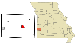
Stockton is a city in Cedar County, Missouri, United States. The population was 1,683 at the 2020 census. It is the county seat of Cedar County.

<span class="mw-page-title-main">Owensville, Missouri</span> City in Missouri, United States

Owensville is a city in Gasconade County, Missouri, United States. The population was 2,757 at the 2020 census.

<span class="mw-page-title-main">Ironton, Missouri</span> City in Missouri, United States

Ironton is a city in Iron County, Missouri, United States. The population was 1,475 at the 2020 census. It is the county seat of Iron County, and is located 12 miles south of Belgrade.

<span class="mw-page-title-main">Lebanon, Missouri</span> City in Missouri, United States

Lebanon is a city in and the county seat of Laclede County in Missouri. The population was 14,474 at the time of the 2010 census. It is the county seat of Laclede County. The Lebanon Micropolitan Statistical Area consists of Laclede County.

<span class="mw-page-title-main">Vienna, Missouri</span> City in Missouri, United States

Vienna is a city in and the county seat of Maries County, Missouri, United States. Its population was 581 at the 2020 census.

<span class="mw-page-title-main">Alton, Missouri</span> City in Missouri, United States

Alton is a city and the county seat of Oregon County, Missouri, United States. The population was 707 at the 2020 census.

<span class="mw-page-title-main">Parkville, Missouri</span> City in Missouri, United States

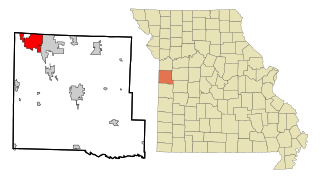
Parkville is a city in Platte County, Missouri, United States and is a part of the Kansas City Metropolitan Area. The population was 7,177 at the 2020 census. Parkville is known for its antique shops, art galleries, and historic downtown. The city is home to Park University, English Landing Park, Platte Landing Park, and the National Golf Club of Kansas City. Large neighborhoods in Parkville include: Riss Lake, The National, Thousand Oaks, Creekside, Parkville Heights, River Hills, Riverchase, The Bluffs, Downtown, and Pinecrest.

<span class="mw-page-title-main">Benton, Missouri</span> City in Missouri, United States

Benton is a city in Scott County, Missouri, United States. The population was 863 at the 2010 census. It is the county seat of Scott County.

<span class="mw-page-title-main">Wentzville, Missouri</span> City in Missouri, United States

Wentzville is an exurb of St. Louis that is located in western St. Charles County, Missouri, United States. As of the 2020 census, the city had a total population of 44,372, making it the 15th largest city in Missouri. Wentzville has been the fastest growing city in Missouri, by percentage population increase, for two consecutive decades from 2000 to 2020. As the site of the Rotary Park, Wentzville is host to the St. Charles County Fair and the St. Louis Renaissance Festival.

<span class="mw-page-title-main">Galena, Missouri</span> City in Missouri, United States

Galena is a city in Stone County, Missouri, United States. The population was 455 at the 2020 census. It is the county seat of Stone County. Galena is part of the Branson, Missouri Micropolitan Statistical Area.

<span class="mw-page-title-main">Houston, Missouri</span> City in Missouri, United States

Houston is a city in Texas County, Missouri, United States. The population was 2,079 at the 2020 census. It is the county seat of Texas County.

<span class="mw-page-title-main">Licking, Missouri</span> City in Missouri, United States

Licking is a city located in Texas County, Missouri, United States. The population was 3,124 at the 2010 census, making it the most populous city in Texas County.

<span class="mw-page-title-main">Hartville, Missouri</span> City in Missouri, United States

Hartville is a city in Wright County, Missouri, United States. The population was 594 at the 2020 census. It is the county seat of Wright County.

<span class="mw-page-title-main">Drexel, Missouri</span> City in Missouri, United States

Drexel is a city in northwest Bates and southwest Cass counties in the U.S. state of Missouri. The population was 968 at the 2020 census.

<span class="mw-page-title-main">Summersville, Missouri</span> City in Missouri, United States

Summersville is a city in Shannon and Texas counties in the U.S. state of Missouri. The population was 453 at the 2020 census.

References

  1. 1 2 3 U.S. Geological Survey Geographic Names Information System: Cabool, Missouri
  2. "ArcGIS REST Services Directory". United States Census Bureau. Retrieved August 28, 2022.
  3. "Cabool MO ZIP Code". zipdatamaps.com. 2023. Retrieved June 16, 2023.
  4. 1 2 "U.S. Census website". United States Census Bureau . Retrieved January 31, 2008.
  5. "Explore Census Data". data.census.gov. Retrieved December 24, 2021.
  6. "KSMU Ozarks Public Radio: How The Town of Cabool Got Its Name". Archived from the original on July 17, 2012. Retrieved March 24, 2012.
  7. Cabool Missouri: The History of Cabool
  8. Cabool Missouri: The Legend of Cabool.
  9. Missouri Atlas & Gazetteer, DeLorme, 1998, First edition, pp. 54 and 64, ISBN   0-89933-224-2
  10. "US Gazetteer files 2010". United States Census Bureau. Archived from the original on January 25, 2012. Retrieved July 8, 2012.
  11. "Census of Population and Housing". Census.gov. Retrieved June 4, 2015.
  12. "U.S. Census website". United States Census Bureau . Retrieved July 8, 2012.
  13. "Schools". Cabool R-IV School District. Retrieved March 18, 2018.
  14. "Branches". Texas County Library. Retrieved March 18, 2018.