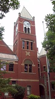
Monongalia County, known locally as Mon County, is located in the U.S. state of West Virginia. As of the 2020 census, the population was 105,822, making it West Virginia's third-most populous county. Its county seat is at Morgantown. The county was founded in 1776. Monongalia County is included in the Morgantown, WV Metropolitan Statistical Area, and is the largest county in North-Central West Virginia. It is part of the Pittsburgh media market.

The Monongahela River —often referred to locally as the Mon —is a 130-mile-long (210 km) river on the Allegheny Plateau in north-central West Virginia and southwestern Pennsylvania. The river flows from the confluence of its west and east forks in north-central West Virginia northeasterly into southwestern Pennsylvania, then northerly to Pittsburgh and its confluence with the Allegheny River to form the Ohio River. The river's entire length is navigable via a series of locks and dams.

The Cheat River is a 78.3-mile-long (126.0 km) tributary of the Monongahela River in eastern West Virginia and southwestern Pennsylvania in the United States. Via the Ohio River, the Cheat and Monongahela are part of the Mississippi River watershed. Owing to the ruggedness of the surrounding Allegheny Mountains, the Cheat remains largely remote with few settlements or developments along its banks. Its headwaters are in the Cheat-Potomac Ranger District of the Monongahela National Forest.

The Battle of Cheat Mountain, also known as the Battle of Cheat Summit Fort, took place from September 12 to 15, 1861, in Pocahontas County and Randolph County, Virginia as part of the Western Virginia Campaign during the American Civil War. It was the first battle of the Civil War in which Robert E. Lee led troops into combat. During the battle, Lee attempted to surround the Union garrison atop Cheat Mountain, but the attack was never launched, due to false information from prisoners and poor communications among the various Confederate commands.

The Black Fork is a principal tributary of the Cheat River in the Allegheny Mountains of eastern West Virginia, USA. It is a short stream, about four miles (6 km) in length, formed by the confluence of two other streams not far above its mouth. It was traditionally considered one of the five Forks of Cheat.

Shavers Fork of the Cheat River is situated in the Allegheny Mountains of eastern West Virginia, USA. It is 88.5 mi (142.5 km) long and forms the Cheat at its confluence with Black Fork at Parsons. It was traditionally considered one of the five Forks of Cheat and its upper reaches constitute the highest river in the eastern United States.

The Dry Fork is a 39.1-mile-long (62.9 km) tributary of the Black Fork of the Cheat River in the Allegheny Mountains of eastern West Virginia, USA. Via the Black Fork, the Cheat, and the Monongahela and Ohio rivers, it is part of the watershed of the Mississippi River. The Dry Fork flows for much of its length in the Monongahela National Forest and drains mostly rural and forested areas. It was traditionally considered one of the five Forks of Cheat.

Cheat Mountain is an exceptionally high and rugged ridge situated in the Allegheny Mountains of eastern West Virginia, USA. It is about 50 miles (80 km) long and more than five miles (8 km) wide at its widest. Its highest point is at its southernmost end at Thorny Flat, which has an elevation of 4,848 feet (1,478 m). Several other knobs rise above 4,000 feet (1,200 m) along its length.

Coopers Rock State Forest is a 12,747-acre (52 km2) state forest in Monongalia and Preston counties in the U.S. state of West Virginia. Its southern edge abuts Cheat Lake and the canyon section of Cheat River, a popular whitewater rafting river in the eastern United States.

Glady Fork is a 31.9-mile-long (51.3 km) river in the Allegheny Mountains of eastern West Virginia, USA. It is considered one of the five principal headwaters tributaries of the Cheat River — known as the Forks of Cheat.

Laurel Fork is a 37.8-mile-long (60.8 km) river in eastern West Virginia, USA. It is a tributary of the Dry Fork; via the Dry Fork, the Black Fork, and the Cheat, Monongahela and Ohio rivers, it is part of the watershed of the Mississippi River, draining an area of 60 square miles (160 km2) in the Allegheny Mountains. With the Dry Fork, the Glady Fork, the Shavers Fork and the Blackwater River, it is considered to be one of the five principal headwaters tributaries of the Cheat River.

Back Allegheny Mountain is a long mountain ridge in eastern West Virginia. It is part of the Shavers Fork Mountain Complex in the Allegheny Range of the Appalachians.
White Top is a knob and spur of Cheat Mountain in southeastern Randolph County, West Virginia, USA. Sitting at an elevation of 4,085 feet (1,245 m), it is located just west of the Shavers Fork of Cheat River and Cheat Bridge. While White Top was originally crossed by the Staunton-Parkersburg Turnpike, modern-day U.S. Route 250 skirts the base of the knob beside Shavers Fork to the north and east.

The Snake Hill Wildlife Management Area is a hill area covering 3,092 acres (1,251 ha) along the Cheat canyon (78.3-mile-long) in Monongalia and Preston Counties, West Virginia. The wildlife management area mostly lies directly south of Coopers Rock State Forest, protecting the southern side of Cheat Canyon. The canyon has been the object of controversy as environmental activists contended with timber and development interests over the years of its preservation status.
Mont Chateau State Park was formerly a state park located beside Cheat Lake in Monongalia County, West Virginia, USA.

This is a list of the National Register of Historic Places listings in Randolph County, West Virginia.
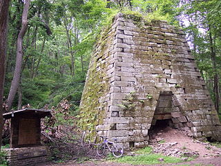
Henry Clay Furnace is an historic iron furnace located in Cooper's Rock State Forest near Cheat Neck, Monongalia County, West Virginia. It was built between 1834 and 1836 by Leonard Lamb. It is a 30-foot square, 30 feet high stone structure in the shape of a truncated pyramid. It was the first steam-powered blast furnace to be built in Western Virginia and had a capacity to produce 4 tons of pig iron per day. In 1839 it was sold to the Ellicott Brothers, who also purchased the Jackson Ironworks at the same time. They made significant improvements, such as connecting it via tram lines to their ironworks at Ices Ferry. It supported a community of approximately 100 people. The small settlement included a school, store and a church. No structures apart from the furnace exist today. It is believed to have ceased production in 1847-48 when the Ellicott's business failed. The furnace may have continued to operate until 1868 when all the Cheat River iron works ceased production. It is among the ten or more abandoned iron furnaces still existing in northern West Virginia.
Stewartstown is an unincorporated community in Monongalia County, West Virginia, United States.
Cheat Canyon Wildlife Management Area is located on 3,836 acres (1,552 ha) northwest of Albright in Preston County, West Virginia. The wildlife management area is centered on the Cheat River canyon.


