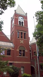
Monongalia County, known locally as Mon County, is located in the U.S. state of West Virginia. As of the 2020 census, the population was 105,822, making it West Virginia's third-most populous county. Its county seat is at Morgantown. The county was founded in 1776. Monongalia County is included in the Morgantown, WV Metropolitan Statistical Area, and is the largest county in North-Central West Virginia. It is part of the Pittsburgh media market.
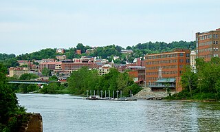
Morgantown is a city in and the county seat of Monongalia County, West Virginia, United States, situated along the Monongahela River. The largest city in North-Central West Virginia, Morgantown is best known as the home of West Virginia University. The population was 30,712 at the 2020 census. The city serves as the anchor of the Morgantown metropolitan area, which had a population of 138,176 in 2020.

The Monongahela River —often referred to locally as the Mon —is a 130-mile-long (210 km) river on the Allegheny Plateau in north-central West Virginia and southwestern Pennsylvania. The river flows from the confluence of its west and east forks in north-central West Virginia northeasterly into southwestern Pennsylvania, then northerly to Pittsburgh and its confluence with the Allegheny River to form the Ohio River. The river's entire length is navigable via a series of locks and dams.

The Cheat River is a 78.3-mile-long (126.0 km) tributary of the Monongahela River in eastern West Virginia and southwestern Pennsylvania in the United States. Via the Ohio River, the Cheat and Monongahela are part of the Mississippi River watershed. Owing to the ruggedness of the surrounding Allegheny Mountains, the Cheat remains largely remote with few settlements or developments along its banks. Its headwaters are in the Cheat-Potomac Ranger District of the Monongahela National Forest.

The Greenbrier River is a tributary of the New River, 162 miles (261 km) long, in southeastern West Virginia, in the United States. Via the New, Kanawha and Ohio rivers, it is part of the watershed of the Mississippi River, draining an area of 1,656 square miles (4,290 km2). It is one of the longest rivers in West Virginia.

The District of West Augusta was a short-lived (1774–76) historical region of Colonial Virginia that encompassed much of what is now northern West Virginia and southwestern Pennsylvania.

The Tygart Valley River — also known as the Tygart River — is a principal tributary of the Monongahela River, approximately 135 miles (217 km) long, in east-central West Virginia in the United States. Via the Monongahela and Ohio rivers, it is part of the watershed of the Mississippi River, draining an area of 1,329 square miles (3,440 km2) in the Allegheny Mountains and the unglaciated portion of the Allegheny Plateau.

The Black Fork is a principal tributary of the Cheat River in the Allegheny Mountains of eastern West Virginia, USA. It is a short stream, about four miles (6 km) in length, formed by the confluence of two other streams not far above its mouth. It was traditionally considered one of the five Forks of Cheat.

Shavers Fork of the Cheat River is situated in the Allegheny Mountains of eastern West Virginia, USA. It is 88.5 mi (142.5 km) long and forms the Cheat at its confluence with Black Fork at Parsons. It was traditionally considered one of the five Forks of Cheat and its upper reaches constitute the highest river in the eastern United States.

The Dry Fork is a 39.1-mile-long (62.9 km) tributary of the Black Fork of the Cheat River in the Allegheny Mountains of eastern West Virginia, USA. Via the Black Fork, the Cheat, and the Monongahela and Ohio rivers, it is part of the watershed of the Mississippi River. The Dry Fork flows for much of its length in the Monongahela National Forest and drains mostly rural and forested areas. It was traditionally considered one of the five Forks of Cheat.

Capon Chapel, also historically known as Capon Baptist Chapel and Capon Chapel Church, is a mid-19th century United Methodist church located near to the town of Capon Bridge, West Virginia, in the United States. Capon Chapel is one of the oldest existing log churches in Hampshire County, along with Mount Bethel Church and Old Pine Church.
West Virginia Route 705 is a short east–west state highway partially located within the Monongalia County city of Morgantown in the U.S. state of West Virginia. The western terminus of the route is at U.S. Route 19 and West Virginia Route 7, directly in front of the WVU Coliseum. The eastern terminus is at U.S. Route 119 near the Morgantown Municipal Airport. The route is major road in northern Morgantown. It is maintained by the West Virginia Department of Transportation.
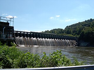
Cheat Lake is a 13-mile-long (21 km) reservoir on the Cheat River in Monongalia County, West Virginia, United States. It was originally named Lake Lynn, but the Board on Geographic Names officially decided upon Cheat Lake as the reservoir's name in 1976. The surface area of Cheat Lake is about 1,730 acres (700 ha), the volume is approximately 128.016 cubic kilometres (30.713 cu mi), and it is located immediately downstream of the 10-mile-long (16 km) Cheat Canyon.
Ruth Rowan is an American politician from the U.S. state of West Virginia. She is a member of the Republican Party and is currently the West Virginia House of Delegates member from the 57th District, which represents parts of Mineral County and Hampshire County in West Virginia's Eastern Panhandle. In 2004, she defeated the embattled House Delegate Jerry Mezzatesta for his seat after he was embroiled in a political scandal in 2003-04.
University High School is a senior high school in unincorporated Monongalia County, West Virginia, near Morgantown. A part of Monongalia County Schools, it houses just over 1,250 students. It is a part of the Monongalia County Schools. Students largely come from the 2 feeder schools, Mountaineer Middle School, and Westwood Middle School.

Glady Fork is a 31.9-mile-long (51.3 km) river in the Allegheny Mountains of eastern West Virginia, USA. It is considered one of the five principal headwaters tributaries of the Cheat River — known as the Forks of Cheat.

Laurel Fork is a 37.8-mile-long (60.8 km) river in eastern West Virginia, USA. It is a tributary of the Dry Fork; via the Dry Fork, the Black Fork, and the Cheat, Monongahela and Ohio rivers, it is part of the watershed of the Mississippi River, draining an area of 60 square miles (160 km2) in the Allegheny Mountains. With the Dry Fork, the Glady Fork, the Shavers Fork and the Blackwater River, it is considered to be one of the five principal headwaters tributaries of the Cheat River.

The Corbly Family massacre refers to the massacre of members of the family of the Rev. John Corbly by Indians on May 10, 1782.
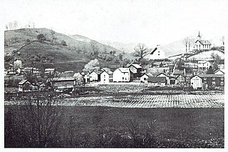
Wadestown — formerly West Warren — is an unincorporated community in Monongalia County, West Virginia, United States. It is located on West Virginia Route 7, approximately 7.5 miles (12.1 km) west-southwest of Blacksville.


