Clarington, Ohio

Last updated

Clarington, Ohio
Clarington Market Street.jpg
Houses on Market Street
OHMap-doton-Clarington.png
Location of Clarington, Ohio
Map of Monroe County Ohio Highlighting Clarington Village.png
Location of Clarington in Monroe County
Coordinates: 39°46′22″N80°52′15″W / 39.77278°N 80.87083°W / 39.77278; -80.87083
Country United States
State Ohio
County Monroe
Township Salem
Area
[1]
  Total1.24 sq mi (3.22 km2)
  Land1.14 sq mi (2.96 km2)
  Water0.10 sq mi (0.26 km2)
Elevation
[2]
640 ft (200 m)
Population
 (2020)
  Total280
  Density244.76/sq mi (94.49/km2)
Time zone UTC-5 (Eastern (EST))
  Summer (DST) UTC-4 (EDT)
ZIP code
43915
Area code 740
FIPS code 39-15210 [3]
GNIS feature ID2397630 [2]

Clarington is a village in Monroe County, Ohio, United States, along the Ohio River. The population was 280 at the 2020 census.

Contents

History

Clarington was described in 1833 as having two stores, one tavern, one physician and ten residential houses.

During the mid-1800s, Clarington grew considerably and soon was a booming river port town with nearly 1,500 residents. The village boasted a cigar factory, blacksmith shop, restaurants, lodgings, and employed many residents at the local boat yard. Mozena Brothers Boat Yard designed and built many western river steam "packet-boats" on site in Clarington near the mouth of Sunfish Creek. [4] Most famous of these boats was the 1912 built Liberty. A mural of the boat by artist Ruston Baker can be seen in town. By the late 1920s, boat building was on the decline and Mozena Brothers sold out to Cook Brothers & Thomas Boat Yard. Barges, small gas powered ferries, and other craft continued to be built in Clarington up to 1941. Geographically, Clarington was the last port on the Ohio River before crossing the Mason–Dixon line just a few miles south of the village. [5] Noted author, river historian, and educator J. Mack Gamble was a lifelong resident of the town. [6]

The non-profit Ohio Valley River Museum in Clarington serves to preserve and promote the history of Clarington's past, western river steamboats, the impact of river industries, and the role it plays in future development. [7] The current museum president is Taylor Abbott. Barbara Rush serves as director. The museum is operated by a nine-member board of directors. [8]

In recent years, Clarington has become an epicenter of oil and gas activity after drilling discoveries of Utica and Marcellus gas formations. As of late 2014, Appalachian Resins had signed a letter of intent to lease 50 acres in Clarington. The Houston-based company plans to construct a $1 billion plant on the site that will use ethane, a component of natural gas, from the nearby Utica and Marcellus formations and break it down into ethylene. The project is considered a major development and boost to the economy of Monroe County following the closure of the Ormet aluminum plant. [9]

Geography

According to the United States Census Bureau, the village has a total area of 1.24 square miles (3.21 km2), of which, 1.14 square miles (2.95 km2) is land and 0.10 square miles (0.26 km2) is water. [10]

Climate

The climate in this area is characterized by relatively high temperatures and evenly distributed precipitation throughout the year. According to the Köppen Climate Classification system, Clarington has a Humid subtropical climate, abbreviated "Cfa" on climate maps. [11]

Climate data for Clarington, Ohio
MonthJanFebMarAprMayJunJulAugSepOctNovDecYear
Mean daily maximum °C (°F)6
(42)
7
(44)
13
(56)
19
(66)
24
(76)
28
(82)
30
(86)
29
(85)
27
(81)
21
(69)
12
(54)
6
(43)
18
(65)
Mean daily minimum °C (°F)−6
(22)
−6
(22)
−1
(31)
4
(39)
9
(49)
14
(57)
16
(61)
16
(61)
12
(54)
6
(42)
0
(32)
−4
(25)
5
(41)
Average precipitation mm (inches)94
(3.7)
79
(3.1)
99
(3.9)
97
(3.8)
110
(4.2)
110
(4.3)
110
(4.5)
100
(4)
76
(3)
74
(2.9)
76
(3)
84
(3.3)
1,110
(43.7)
Source: Weatherbase [12]

Demographics

Historical population
CensusPop.Note
1850 341
1870 728
1880 91525.7%
1890 762−16.7%
1900 90518.8%
1910 784−13.4%
1920 607−22.6%
1930 506−16.6%
1940 490−3.2%
1950 478−2.4%
1960 394−17.6%
1970 338−14.2%
1980 55865.1%
1990 406−27.2%
2000 4449.4%
2010 384−13.5%
2020 280−27.1%
U.S. Decennial Census [13] [14]

2010 census

As of the census [15] of 2010, there were 384 people, 165 households, and 107 families residing in the village. The population density was 336.8 inhabitants per square mile (130.0/km2). There were 186 housing units at an average density of 163.2 per square mile (63.0/km2). The racial makeup of the village was 96.9% White, 1.0% African American, and 2.1% from two or more races. Hispanic or Latino of any race were 0.3% of the population.

There were 165 households, of which 29.1% had children under the age of 18 living with them, 42.4% were married couples living together, 16.4% had a female householder with no husband present, 6.1% had a male householder with no wife present, and 35.2% were non-families. 32.1% of all households were made up of individuals, and 13.9% had someone living alone who was 65 years of age or older. The average household size was 2.33 and the average family size was 2.88.

The median age in the village was 40.3 years. 23.4% of residents were under the age of 18; 8.9% were between the ages of 18 and 24; 24.2% were from 25 to 44; 28.1% were from 45 to 64; and 15.4% were 65 years of age or older. The gender makeup of the village was 44.5% male and 55.5% female.

2000 census

As of the census [3] of 2000, there were 444 people, 182 households, and 125 families residing in the village. The population density was 397.3 inhabitants per square mile (153.4/km2). There were 209 housing units at an average density of 187.0 per square mile (72.2/km2). The racial makeup of the village was 99.10% White, 0.68% African American, and 0.23% from two or more races. Hispanic or Latino of any race were 0.68% of the population.

There were 182 households, out of which 28.6% had children under the age of 18 living with them, 51.6% were married couples living together, 12.1% had a female householder with no husband present, and 30.8% were non-families. 23.6% of all households were made up of individuals, and 15.4% had someone living alone who was 65 years of age or older. The average household size was 2.44 and the average family size was 2.89.

In the village, the population was spread out, with 23.0% under the age of 18, 6.8% from 18 to 24, 28.2% from 25 to 44, 23.9% from 45 to 64, and 18.2% who were 65 years of age or older. The median age was 40 years. For every 100 females, there were 89.7 males. For every 100 females age 18 and over, there were 86.9 males.

The median income for a household in the village was $28,281, and the median income for a family was $31,875. Males had a median income of $30,750 versus $20,938 for females. The per capita income for the village was $13,730. About 21.4% of families and 25.2% of the population were below the poverty line, including 31.1% of those under age 18 and 15.0% of those age 65 or over.

See also

Related Research Articles

<span class="mw-page-title-main">Monroe County, Ohio</span> County in Ohio, United States

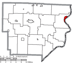
Monroe County is a county located on the eastern border of the U.S. state of Ohio, across the Ohio River from West Virginia. As of the 2020 census, the population was 13,385, making it the second-least populous county in Ohio. Its county seat is Woodsfield. The county was created in 1813 and later organized in 1815.

<span class="mw-page-title-main">Powhatan, Louisiana</span> Village in Louisiana, United States

Powhatan is a village in Natchitoches Parish, Louisiana, United States. The population was 141 at the 2000 census. It is part of the Natchitoches Micropolitan Statistical Area.

Vanceboro is a town in Washington County, Maine, United States. The town was named after landowner William Vance. The main village in town is located at the eastern terminus of Maine State Route 6. Vanceboro is across the St. Croix River from St. Croix, New Brunswick, Canada, to which it is connected by the Saint Croix–Vanceboro Bridge. Vanceboro is also connected to St. Croix by the Saint Croix–Vanceboro Railway Bridge, which is used by the New Brunswick Southern Railway.

<span class="mw-page-title-main">Dundee, Michigan</span> Village in Michigan, United States

Dundee is a village in Monroe County in the U.S. state of Michigan. The population was 5,323 at the 2020 census, up from 3,957 in 2010. The village is within Dundee Township and is served by Dundee Community Schools.

<span class="mw-page-title-main">Powhatan Point, Ohio</span> Village in Ohio, United States

Powhatan Point is a village in southeastern Belmont County, Ohio, United States, along the Ohio River. The population was 1,461 at the 2020 census. It is part of the Wheeling metropolitan area.

<span class="mw-page-title-main">Aberdeen, Ohio</span> Village in Ohio, United States

Aberdeen is a village in Huntington Township, Brown County, Ohio, United States, along the Ohio River 50 miles (80 km) southeast of Cincinnati. The population was 1,515 at the 2020 census.

<span class="mw-page-title-main">Johnstown, Ohio</span> City in Ohio, United States

Johnstown is a city in Licking County, Ohio, United States. The population was 5,278 at the 2022 census. The city is most notable for the Johnnies-Vikings rivalry and the finding of a nearly complete mastodon skeleton under the city.

<span class="mw-page-title-main">Jerusalem, Ohio</span> Village in Ohio, United States

Jerusalem is a village in Monroe County, Ohio, United States. The population was 121 at the 2020 census.

<span class="mw-page-title-main">Miltonsburg, Ohio</span> Village in Ohio, United States

Miltonsburg is a village in Monroe County, Ohio, United States. The population was 42 at the 2020 census. Miltonsburg was named after Milton Pierson, son of Ohio pioneer David Pierson. David Pierson named Clarington, Ohio after his daughter Clarinda.

<span class="mw-page-title-main">Belpre, Ohio</span> City in Ohio, United States

Belpre is a city in Washington County, Ohio, United States, along the Ohio River across from Parkersburg, West Virginia. The population was 6,728 at the 2020 census. Its name derives from "Belle Prairie", the name given to the valley by French trappers prior to the first American settlement at the site.

<span class="mw-page-title-main">Loudon, Tennessee</span> City in Tennessee, United States

Loudon is a city in and the county seat of Loudon County, Tennessee, United States. Its population was 6,001 at the 2020 census. It is included in the Knoxville, Tennessee Metropolitan Statistical Area. The city is located in East Tennessee, southwest of Knoxville, on the Tennessee River. Fort Loudoun, the colonial era fort for which the city was named, is located several miles to the south in Monroe County.

<span class="mw-page-title-main">Morristown, Vermont</span> Town in Vermont, United States

Morristown is a town in Lamoille County, Vermont, United States. As of the 2020 census, the population was 5,434. Morristown is the largest town by population in Lamoille County, and its central village of Morrisville serves as the county's main commercial center.

<span class="mw-page-title-main">Beech Bottom, West Virginia</span> Village in West Virginia, United States

Beech Bottom is a village in Brooke County, West Virginia, United States, situated along the Ohio River. The population was 523 at the 2010 census. It is part of the Weirton–Steubenville metropolitan area.

<span class="mw-page-title-main">Henderson, West Virginia</span> Unincorporated Town in West Virginia, United States

Henderson is an unincorporated community and former town in Mason County, West Virginia, United States, at the confluence of the Ohio and Kanawha Rivers. The population was 231 at the 2020 census. It is part of the Point Pleasant, WV–OH Micropolitan Statistical Area. The town was incorporated in 1893 and named for Samuel Bruce Henderson, who owned the townsite at the time. The town was unincorporated following a public hearing on August 11, 2022.

<span class="mw-page-title-main">New Martinsville, West Virginia</span> City in West Virginia, United States

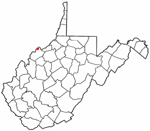
New Martinsville is a city in and the county seat of Wetzel County, West Virginia, United States, along the Ohio River. The population was 5,186 at the 2020 census.

<span class="mw-page-title-main">Boaz, West Virginia</span> CDP in West Virginia, United States

Boaz is a census-designated place (CDP) in Wood County, West Virginia, United States. It is part of the Parkersburg-Marietta-Vienna, WV-OH Metropolitan Statistical Area. As of the 2020 census, the CDP population was 1,321.

<span class="mw-page-title-main">Williamstown, West Virginia</span> City in West Virginia, United States

Williamstown is a city in Wood County, West Virginia, United States, along the Ohio River. It is part of the Parkersburg–Vienna metropolitan area. The population was 2,997 at the 2020 census. The now closed Fenton Art Glass Company was located in the city.

<span class="mw-page-title-main">Wilson, Ohio</span> Village in Ohio, United States

Wilson is a village in Belmont and Monroe counties in the U.S. state of Ohio. The population was 129 at the 2020 census. It is part of the Wheeling metropolitan area.

<span class="mw-page-title-main">Yorkville, Ohio</span> Village in Ohio, United States

Yorkville is a village in Belmont and Jefferson counties in the U.S. state of Ohio. The population was 968 at the 2020 census. Yorkville lies within two Metropolitan Statistical Areas; the Belmont County portion is part of the Wheeling metropolitan area, while the Jefferson County portion is part of the Weirton–Steubenville metropolitan area.

<span class="mw-page-title-main">Fairchild, Wisconsin</span> Village in Wisconsin, United States

Fairchild is a village in Eau Claire County, Wisconsin, United States. The population was 550 at the 2010 census. The village is located within the Town of Fairchild.

References

  1. "ArcGIS REST Services Directory". United States Census Bureau. Retrieved September 20, 2022.
  2. 1 2 U.S. Geological Survey Geographic Names Information System: Clarington, Ohio
  3. 1 2 "U.S. Census website". United States Census Bureau . Retrieved January 31, 2008.
  4. "Monroe County river museum coming - MariettaTimes.com - News, Sports, Jobs, Ohio, Community Information - The Marietta Times" . Retrieved July 18, 2016.
  5. "History of the Ohio River in southeastern Ohio" . Retrieved July 18, 2016.
  6. "Sunfish Creek Festival Will Be Held Saturday - WetzelChronicle.com - News, information, New Martinsville and Wetzel County WV - Wetzel Chronicle" . Retrieved July 18, 2016.
  7. "Ohio Valley River Museum - WetzelChronicle.com - News, information, New Martinsville and Wetzel County WV - Wetzel Chronicle" . Retrieved July 18, 2016.
  8. "History of the Ohio River in southeastern Ohio" . Retrieved July 18, 2016.
  9. "'Cracker' plant in the works for Monroe County" . Retrieved July 18, 2016.
  10. "US Gazetteer files 2010". United States Census Bureau. Archived from the original on January 25, 2012. Retrieved January 6, 2013.
  11. "Clarington, Ohio Köppen Climate Classification (Weatherbase)" . Retrieved July 18, 2016.
  12. "Weatherbase.com". Weatherbase. 2013. Retrieved on September 15, 2013.
  13. "Census of Population and Housing". Census.gov. Retrieved June 4, 2015.
  14. "Profile of General Population and Housing Characteristics: 2010 Demographic Profile Data (DP-1): Clarington village, Ohio". United States Census Bureau . Retrieved June 1, 2012.
  15. "U.S. Census website". United States Census Bureau . Retrieved January 6, 2013.