Graysville, Ohio | |
---|---|
Coordinates: 39°39′48″N81°10′29″W / 39.66333°N 81.17472°W | |
Country | United States |
State | Ohio |
County | Monroe |
Township | Washington |
Area | |
• Total | 1.01 sq mi (2.61 km2) |
• Land | 1.01 sq mi (2.61 km2) |
• Water | 0.00 sq mi (0.00 km2) |
Elevation | 1,053 ft (321 m) |
Population (2020) | |
• Total | 70 |
• Density | 69.51/sq mi (26.84/km2) |
Time zone | UTC-5 (Eastern (EST)) |
• Summer (DST) | UTC-4 (EDT) |
ZIP code | 45734 |
Area code | 740 |
FIPS code | 39-31542 [3] |
GNIS feature ID | 2398199 [2] |
Graysville is a village in Monroe County, Ohio, United States. The population was 70 at the 2020 census.
According to the United States Census Bureau, the village has a total area of 1.01 square miles (2.62 km2), all of it land. [4]
Census | Pop. | Note | %± |
---|---|---|---|
1870 | 199 | — | |
1880 | 174 | −12.6% | |
1890 | 107 | −38.5% | |
1900 | 174 | 62.6% | |
1910 | 166 | −4.6% | |
1920 | 187 | 12.7% | |
1930 | 192 | 2.7% | |
1940 | 170 | −11.5% | |
1950 | 138 | −18.8% | |
1960 | 127 | −8.0% | |
1970 | 97 | −23.6% | |
1980 | 112 | 15.5% | |
1990 | 89 | −20.5% | |
2000 | 113 | 27.0% | |
2010 | 76 | −32.7% | |
2020 | 70 | −7.9% | |
U.S. Decennial Census [5] [6] |
As of the census [7] of 2010, there were 76 people, 34 households, and 25 families living in the village. The population density was 75.2 inhabitants per square mile (29.0/km2). There were 38 housing units at an average density of 37.6 per square mile (14.5/km2). The racial makeup of the village was 89.5% White and 10.5% from two or more races.
There were 34 households, of which 23.5% had children under the age of 18 living with them, 58.8% were married couples living together, 8.8% had a female householder with no husband present, 5.9% had a male householder with no wife present, and 26.5% were non-families. 26.5% of all households were made up of individuals, and 11.8% had someone living alone who was 65 years of age or older. The average household size was 2.24 and the average family size was 2.64.
The median age in the village was 48 years. 18.4% of residents were under the age of 18; 3.8% were between the ages of 18 and 24; 22.4% were from 25 to 44; 39.4% were from 45 to 64; and 15.8% were 65 years of age or older. The gender makeup of the village was 50.0% male and 50.0% female.
As of the census [3] of 2000, there were 113 people, 41 households, and 33 families living in the village. The population density was 113.4 inhabitants per square mile (43.8/km2). There were 45 housing units at an average density of 45.2 per square mile (17.5/km2). The racial makeup of the village was 100.00% White. Hispanic or Latino of any race were 1.77% of the population.
There were 41 households, out of which 34.1% had children under the age of 18 living with them, 70.7% were married couples living together, 4.9% had a female householder with no husband present, and 19.5% were non-families. 14.6% of all households were made up of individuals, and 7.3% had someone living alone who was 65 years of age or older. The average household size was 2.76 and the average family size was 2.97.
In the village, the population was spread out, with 30.1% under the age of 18, 6.2% from 18 to 24, 26.5% from 25 to 44, 17.7% from 45 to 64, and 19.5% who were 65 years of age or older. The median age was 36 years. For every 100 females there were 109.3 males. For every 100 females age 18 and over, there were 97.5 males.
The median income for a household in the village was $24,286, and the median income for a family was $24,643. Males had a median income of $32,000 versus $20,000 for females. The per capita income for the village was $9,810. There were 13.9% of families and 28.8% of the population living below the poverty line, including 38.0% of under eighteens and 10.5% of those over 64.
Catoosa County is a county located in the northwestern part of the U.S. state of Georgia. As of the 2020 census, the population was 67,872. The county seat is Ringgold. The county was created on December 5, 1853. The meaning of the Cherokee language name "Catoosa" is obscure: "Catoosa" may come from the Cherokee words gatusi or gatu'gitse.
Graysville is a city in northwestern Jefferson County, Alabama, United States, located north of Adamsville. At the 2020 census, the population was 1,950.
Lewis and Clark Village is a village in Buchanan County, Missouri, United States. The population was 96 at the 2020 census. It is part of the St. Joseph, MO–KS Metropolitan Statistical Area.
Country Life Acres is a village in St. Louis County, Missouri, United States. The population was 72 at the 2020 census.
Westwood is a village in west St. Louis County, Missouri, United States. The population was 316 at the 2020 census.
Cedar Creek is a village in Cass County, Nebraska, United States. The population was 465 at the 2020 census.
Murdock is a village in Cass County, Nebraska, United States. The population was 270 according to the 2020 census.
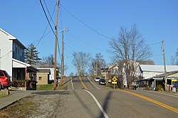
Nellie is a village in Coshocton County, Ohio, United States, along the Walhonding River. The population was 122 at the 2020 census.
Walton Hills is a village in Cuyahoga County, Ohio, United States. The population was 2,033 at the 2020 census. A suburb of Cleveland, it is a part of the Cleveland metropolitan area.
Gordon is a village in Darke County, Ohio, United States. The population was 245 at the 2020 census.
Palestine is a village in Darke County, Ohio, United States. The population was 180 at the 2020 census.
Valleyview is a village in Franklin County, Ohio, United States. The population was 669 at the 2020 census.
Gray Township is a township in Greene County, Pennsylvania, United States. The population was 182 at the 2020 census.
Graysville is a town in Rhea County, Tennessee, United States. The population was 1,471 at the 2020 census and 1,502 at the 2010 census.
Avoca is a village in Iowa County, Wisconsin, United States. The population was 637 at the 2010 census. It is part of the Madison Metropolitan Statistical Area. It is named after Avoca in Ireland.
Bay City is a village on the Mississippi River in Pierce County, Wisconsin, United States. The population was 500 at the 2010 census.
Weyerhaeuser is a village in Rusk County, Wisconsin, United States. The population was 238 at the 2010 census.
Verona is a village in Montgomery and Preble counties in the U.S. state of Ohio. The population was 403 at the 2020 census. It is part of the Dayton Metropolitan Statistical Area.
Dorchester is a village in Clark and Marathon counties in the U.S. state of Wisconsin, along the 45th parallel. It is part of the Wausau, Wisconsin Metropolitan Statistical Area. The population was 876 at the 2010 census. Of this, 871 were in Clark County, and only 5 were in Marathon County.
Lowell is a village in Dodge County, Wisconsin, United States, along the Beaver Dam River. The population was 340 at the 2010 census. The village is located within the Town of Lowell.