Miltonsburg, Ohio

Last updated

Miltonsburg, Ohio
Miltonsburg southern.jpg
OHMap-doton-Miltonsburg.png
Location of Miltonsburg, Ohio
Detailed map of Miltonsburg, Ohio.png
Detailed map of Miltonsburg
Coordinates: 39°49′53″N81°09′53″W / 39.83139°N 81.16472°W / 39.83139; -81.16472
Country United States
State Ohio
County Monroe
Township Malaga
Area
[1]
  Total0.07 sq mi (0.19 km2)
  Land0.07 sq mi (0.19 km2)
  Water0.00 sq mi (0.00 km2)
Elevation
[2]
1,293 ft (394 m)
Population
 (2020)
  Total42
  Density575.34/sq mi (223.03/km2)
Time zone UTC-5 (Eastern (EST))
  Summer (DST) UTC-4 (EDT)
FIPS code 39-50722 [3]
GNIS feature ID2399368 [2]

Miltonsburg is a village in Monroe County, Ohio, United States. The population was 42 at the 2020 census. Miltonsburg was named after Milton Pierson, son of Ohio pioneer David Pierson. David Pierson named Clarington, Ohio after his daughter Clarinda.

Contents

Geography

According to the United States Census Bureau, the village has a total area of 0.07 square miles (0.18 km2), all of it land. [4]

Demographics

Historical population
CensusPop.Note
1850 145
1870 176
1880 152−13.6%
1890 123−19.1%
1900 1305.7%
1910 92−29.2%
1920 84−8.7%
1930 69−17.9%
1940 8624.6%
1950 10016.3%
1960 11616.0%
1970 68−41.4%
1980 10960.3%
1990 56−48.6%
2000 29−48.2%
2010 4348.3%
2020 42−2.3%
U.S. Decennial Census [5] [6]

2010 census

As of the census [7] of 2010, there were 43 people, 19 households, and 12 families living in the village. The population density was 614.3 inhabitants per square mile (237.2/km2). There were 25 housing units at an average density of 357.1 per square mile (137.9/km2). The racial makeup of the village was 100.0% White.

There were 19 households, of which 36.8% had children under the age of 18 living with them, 47.4% were married couples living together, 10.5% had a female householder with no husband present, 5.3% had a male householder with no wife present, and 36.8% were non-families. 31.6% of all households were made up of individuals. The average household size was 2.26 and the average family size was 2.67.

The median age in the village was 42.8 years. 20.9% of residents were under the age of 18; 4.7% were between the ages of 18 and 24; 35% were from 25 to 44; 28% were from 45 to 64; and 11.6% were 65 years of age or older. The gender makeup of the village was 55.8% male and 44.2% female.

2000 census

As of the census [3] of 2000, there were 29 people, 11 households, and 8 families living in the village. The population density was 376.3 inhabitants per square mile (145.3/km2). There were 11 housing units at an average density of 142.7 per square mile (55.1/km2). The racial makeup of the village was 100.00% White.

There were 11 households, out of which 36.4% had children under the age of 18 living with them, 72.7% were married couples living together, and 18.2% were non-families. 18.2% of all households were made up of individuals, and 18.2% had someone living alone who was 65 years of age or older. The average household size was 2.64 and the average family size was 2.89.

In the village, the population was spread out, with 24.1% under the age of 18, 3.4% from 18 to 24, 37.9% from 25 to 44, 20.7% from 45 to 64, and 13.8% who were 65 years of age or older. The median age was 37 years. For every 100 females there were 107.1 males. For every 100 females age 18 and over, there were 100.0 males.

The median income for a household in the village was $43,750, and the median income for a family was $43,750. Males had a median income of $39,583 versus $0 for females. The per capita income for the village was $13,605. None of the population is below the poverty line.

Related Research Articles

<span class="mw-page-title-main">Pierson, Michigan</span> Village in Michigan, United States

Pierson is a village in Montcalm County of the U.S. state of Michigan. The population was 229 at the 2020 census, up from 172 in 2010. The village is within Pierson Township.

<span class="mw-page-title-main">Miramiguoa Park, Missouri</span> Village in Missouri, United States

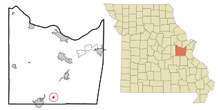
Miramiguoa Park is a village in Franklin County, Missouri, United States. The population was 120 at the 2010 census.

<span class="mw-page-title-main">Polk, Ohio</span> Village in Ohio, United States

Polk is a village in Ashland County, Ohio, United States. The population was 310 at the 2020 census.

<span class="mw-page-title-main">Woodstock, Ohio</span> Village in Ohio, United States

Woodstock is a village in Champaign County, Ohio, United States. The population was 287 at the 2020 census.

<span class="mw-page-title-main">Rossburg, Ohio</span> Village in Ohio, United States

Rossburg is a village in Darke County, Ohio, United States. The population was 159 at the 2020 census.

<span class="mw-page-title-main">Yorkshire, Ohio</span> Village in Ohio, United States

Yorkshire is a village in Darke County, Ohio, United States. The population was 95 at the 2020 census.

<span class="mw-page-title-main">Berlin Heights, Ohio</span> Village in Ohio, United States

Berlin Heights is a village in Berlin Township, Erie County, Ohio, United States. The population was 651 at the 2020 census. It is part of the Sandusky, Ohio Metropolitan Statistical Area.

<span class="mw-page-title-main">Amanda, Ohio</span> Village in Ohio, United States

Amanda is a village in Fairfield County, Ohio, United States. The population was 637 at the 2020 census.

<span class="mw-page-title-main">Riverlea, Ohio</span> Village in Ohio, United States

Riverlea is a village in Franklin County, Ohio, United States, surrounded by Worthington on its north, south, and east sides, and bordered on the west by the Olentangy River, across which is Columbus. Riverlea was incorporated in 1939, a small community that formed on former farmland. The population was 599 at the 2020 census.

<span class="mw-page-title-main">Glenmont, Ohio</span> Village in Ohio, United States

Glenmont is a village in Holmes County, Ohio, United States. The population was 240 at the 2020 census.

<span class="mw-page-title-main">Racine, Ohio</span> Village in Ohio, United States

Racine is a village in Meigs County, Ohio, United States, along the Ohio River. The population was 683 at the 2020 census.

<span class="mw-page-title-main">Norwich, Ohio</span> Village in Ohio, United States

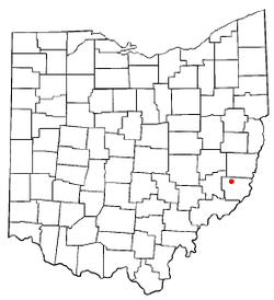
Norwich is a village in Muskingum County, Ohio, United States. The population was 87 at the 2020 census. It is part of the Zanesville micropolitan area.

<span class="mw-page-title-main">Rocky Ridge, Ohio</span> Village in Ohio, United States

Rocky Ridge is a village in Ottawa County, Ohio, United States. The population was 312 at the 2020 census.

<span class="mw-page-title-main">Oakwood, Paulding County, Ohio</span> Village in Ohio, United States

Oakwood is a village in Paulding County, Ohio, United States. The population was 546 at the 2020 census.

<span class="mw-page-title-main">Hamden, Ohio</span> Village in Ohio, United States

Hamden is a village in Vinton County, Ohio, United States. The population was 727 at the 2020 census.

<span class="mw-page-title-main">Macksburg, Ohio</span> Village in Ohio, United States

Macksburg is a village in Washington County, Ohio, United States, along the West Fork of Duck Creek. The population was 120 at the 2020 census. The village is about 28 miles (45 km) south of Cambridge, Ohio.

<span class="mw-page-title-main">Blakeslee, Ohio</span> Village in Ohio, United States

Blakeslee is a village in Williams County, Ohio, United States. The population was 104 at the 2020 census.

<span class="mw-page-title-main">Bradner, Ohio</span> Village in Ohio, United States

Bradner is a village in Wood County, Ohio, United States. The population was 971 at the 2020 census.

<span class="mw-page-title-main">Marseilles, Ohio</span> Village in Ohio, United States

Marseilles is a village in Wyandot County, Ohio, United States, located at the western edge of the Killdeer Plains Wildlife Area. The population was 93 at the 2020 census.

<span class="mw-page-title-main">Clifton, Ohio</span> Village in Ohio, United States

Clifton is a village in Clark and Greene counties in the U.S. state of Ohio and is home to the Clifton Mill, one of the largest water-powered grist mills still in existence. The population was 131 at the 2020 census.

References

  1. "ArcGIS REST Services Directory". United States Census Bureau. Retrieved September 20, 2022.
  2. 1 2 U.S. Geological Survey Geographic Names Information System: Miltonsburg, Ohio
  3. 1 2 "U.S. Census website". United States Census Bureau . Retrieved January 31, 2008.
  4. "US Gazetteer files 2010". United States Census Bureau. Archived from the original on January 25, 2012. Retrieved January 6, 2013.
  5. "Census of Population and Housing". Census.gov. Retrieved June 4, 2015.
  6. "Profile of General Population and Housing Characteristics: 2010 Demographic Profile Data (DP-1): Miltonsburg village, Ohio". United States Census Bureau . Retrieved June 1, 2012.
  7. "U.S. Census website". United States Census Bureau . Retrieved January 6, 2013.