Lewisville, Ohio

Last updated

Lewisville, Ohio
Lewisville overview.jpg
Overview from Back Street
OHMap-doton-Lewisville.png
Location of Lewisville, Ohio
Map of Monroe County Ohio Highlighting Lewisville Village.png
Location of Lewisville in Monroe County
Coordinates: 39°46′01″N81°13′06″W / 39.76694°N 81.21833°W / 39.76694; -81.21833
Country United States
State Ohio
County Monroe
Township Summit
Area
[1]
  Total0.37 sq mi (0.96 km2)
  Land0.37 sq mi (0.96 km2)
  Water0.00 sq mi (0.00 km2)
Elevation
[2]
1,224 ft (373 m)
Population
 (2020)
  Total184
  Density495.96/sq mi (191.66/km2)
Time zone UTC-5 (Eastern (EST))
  Summer (DST) UTC-4 (EDT)
ZIP code
43754
Area code 740
FIPS code 39-42980 [3]
GNIS feature ID2398430 [2]

Lewisville is a village in Monroe County, Ohio, United States. The population was 184 at the 2020 census.

Contents

Geography

According to the United States Census Bureau, the village has a total area of 0.37 square miles (0.96 km2), all of it land. [4]

Demographics

Historical population
CensusPop.Note
1850 96
1870 124
1880 120−3.2%
1900 170
1910 29171.2%
1920 230−21.0%
1930 2310.4%
1940 2529.1%
1950 217−13.9%
1960 193−11.1%
1970 29452.3%
1980 285−3.1%
1990 261−8.4%
2000 233−10.7%
2010 176−24.5%
2020 1844.5%
U.S. Decennial Census [5] [6]

2010 census

As of the census [7] of 2010, there were 176 people, 76 households, and 48 families living in the village. The population density was 475.7 inhabitants per square mile (183.7/km2). There were 97 housing units at an average density of 262.2 per square mile (101.2/km2). The racial makeup of the village was 98.3% White, 0.6% Asian, and 1.1% from two or more races. Hispanic or Latino of any race were 0.6% of the population.

There were 76 households, of which 25.0% had children under the age of 18 living with them, 50.0% were married couples living together, 6.6% had a female householder with no husband present, 6.6% had a male householder with no wife present, and 36.8% were non-families. 31.6% of all households were made up of individuals, and 14.5% had someone living alone who was 65 years of age or older. The average household size was 2.11 and the average family size was 2.67.

The median age in the village was 48.5 years. 17% of residents were under the age of 18; 6.2% were between the ages of 18 and 24; 23.3% were from 25 to 44; 33% were from 45 to 64; and 20.5% were 65 years of age or older. The gender makeup of the village was 46.6% male and 53.4% female.

2000 census

As of the census [3] of 2000, there were 233 people, 95 households, and 64 families living in the village. The population density was 625.4 inhabitants per square mile (241.5/km2). There were 110 housing units at an average density of 295.2 per square mile (114.0/km2). The racial makeup of the village was 99.14% White, 0.43% Asian, and 0.43% from two or more races.

There were 95 households, out of which 28.4% had children under the age of 18 living with them, 57.9% were married couples living together, 9.5% had a female householder with no husband present, and 31.6% were non-families. 30.5% of all households were made up of individuals, and 21.1% had someone living alone who was 65 years of age or older. The average household size was 2.32 and the average family size was 2.91.

In the village, the population was spread out, with 23.6% under the age of 18, 6.4% from 18 to 24, 24.5% from 25 to 44, 24.9% from 45 to 64, and 20.6% who were 65 years of age or older. The median age was 41 years. For every 100 females there were 77.9 males. For every 100 females age 18 and over, there were 79.8 males.

The median income for a household in the village was $24,286, and the median income for a family was $31,042. Males had a median income of $33,750 versus $18,036 for females. The per capita income for the village was $11,150. About 6.5% of families and 10.1% of the population were below the poverty line, including none of those under the age of eighteen and 19.6% of those 65 or over.

Related Research Articles

<span class="mw-page-title-main">Louisville, Alabama</span> Town in Alabama, United States

Louisville is a town in Barbour County, Alabama, United States. At the 2020 census, the population was 395.

<span class="mw-page-title-main">Lewisville, Arkansas</span> City in Arkansas, United States

Lewisville is a city in Lafayette County, Arkansas, United States. The population was 1,280 at the 2010 census. It is the county seat of Lafayette County.

<span class="mw-page-title-main">Lewisville, Idaho</span> City in Idaho, United States

Lewisville is a city in Jefferson County, Idaho, United States. The population was 458 at the 2010 census.

<span class="mw-page-title-main">Lewisville, Indiana</span> Town in Indiana, United States

Lewisville is a town in Franklin Township, Henry County, Indiana, United States. The population was 366 at the 2010 census.

<span class="mw-page-title-main">Bloomfield Township, Huron County, Michigan</span> Civil township in Michigan, United States

Bloomfield Township is a civil township of Huron County in the U.S. state of Michigan. As of the 2020 census, the township population was 404.

<span class="mw-page-title-main">Lewisville, Minnesota</span> City in Minnesota, United States

Lewisville is a city in Watonwan County, Minnesota, United States. The population was 250 at the 2010 census.

<span class="mw-page-title-main">Westwood, Missouri</span> Village in Missouri, United States

Westwood is a village in west St. Louis County, Missouri, United States. The population was 316 at the 2020 census.

<span class="mw-page-title-main">Lewisville, North Carolina</span> Town in North Carolina, United States

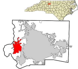
Lewisville is a town in Forsyth County, North Carolina, United States. The population was 13,388 at the 2020 census, up from 12,639 in 2010. It is a Piedmont Triad community.

<span class="mw-page-title-main">Warsaw, Ohio</span> Village in Ohio, United States

Warsaw is a village in Coshocton County, Ohio, United States, along the Walhonding River. The population was 624 at the 2020 census.

<span class="mw-page-title-main">Cuyahoga Heights, Ohio</span> Village in Ohio, United States

Cuyahoga Heights is a village in Cuyahoga County, Ohio, United States. The population was 573 at the 2020 census. A suburb of Cleveland, it is a part of the Cleveland metropolitan area.

<span class="mw-page-title-main">Walton Hills, Ohio</span> Village in Ohio, United States

Walton Hills is a village in Cuyahoga County, Ohio, United States. The population was 2,033 at the 2020 census. A suburb of Cleveland, it is a part of the Cleveland metropolitan area.

<span class="mw-page-title-main">Wayne Lakes, Ohio</span> Village in Ohio, United States

Wayne Lakes is a village in Darke County, Ohio, United States. The population was 693 at the 2020 census.

<span class="mw-page-title-main">Brice, Ohio</span> Village in Ohio, United States

Brice is a village in Franklin County, Ohio, United States, on the southeast side of the Columbus metropolitan area. The population was 93 at the 2020 census.

<span class="mw-page-title-main">Sheffield, Ohio</span> Village in Ohio, United States

Sheffield is a village in Lorain County, Ohio, United States, along the Black River. The population was 4,135 at the 2020 census. It is part of the Cleveland metropolitan area.

<span class="mw-page-title-main">Harpster, Ohio</span> Village in Ohio, United States

Harpster is a village in Wyandot County, Ohio, United States. The population was 160 at the 2020 census.

<span class="mw-page-title-main">Lewisville, Washington</span> Census-designated place in Washington, United States

Lewisville is a census-designated place (CDP) in Clark County, Washington, United States. The population was 1,860 at the 2020 census.

<span class="mw-page-title-main">Browntown, Wisconsin</span> Village in Wisconsin, United States

Browntown is a village in Green County, Wisconsin, United States. The population was 280 at the 2010 census.

<span class="mw-page-title-main">Avoca, Wisconsin</span> Village in Wisconsin, United States

Avoca is a village in Iowa County, Wisconsin, United States. The population was 637 at the 2010 census. It is part of the Madison Metropolitan Statistical Area. It is named after Avoca in Ireland.

<span class="mw-page-title-main">Verona, Ohio</span> Village in Ohio, United States

Verona is a village in Montgomery and Preble counties in the U.S. state of Ohio. The population was 403 at the 2020 census. It is part of the Dayton Metropolitan Statistical Area.

<span class="mw-page-title-main">Lowell, Wisconsin</span> Village in Wisconsin, United States

Lowell is a village in Dodge County, Wisconsin, United States, along the Beaver Dam River. The population was 340 at the 2010 census. The village is located within the Town of Lowell.

References

  1. "ArcGIS REST Services Directory". United States Census Bureau. Retrieved September 20, 2022.
  2. 1 2 U.S. Geological Survey Geographic Names Information System: Lewisville, Ohio
  3. 1 2 "U.S. Census website". United States Census Bureau . Retrieved January 31, 2008.
  4. "US Gazetteer files 2010". United States Census Bureau. Archived from the original on January 12, 2012. Retrieved January 6, 2013.
  5. "Census of Population and Housing". Census.gov. Retrieved June 4, 2015.
  6. "Profile of General Population and Housing Characteristics: 2010 Demographic Profile Data (DP-1): Lewisville village, Ohio". United States Census Bureau . Retrieved June 1, 2012.
  7. "U.S. Census website". United States Census Bureau . Retrieved January 6, 2013.