Clarksburg, Missouri

Last updated

Clarksburg, Missouri
Moniteau County Missouri Incorporated and Unincorporated areas Clarksburg Highlighted.svg
Location in Moniteau County and the state of Missouri
Coordinates: 38°39′40″N92°39′58″W / 38.66111°N 92.66611°W / 38.66111; -92.66611
Country United States
State Missouri
County Moniteau
Founded1884
Named for Postmaster Hiram Clark
Area
[1]
  Total0.58 sq mi (1.50 km2)
  Land0.58 sq mi (1.49 km2)
  Water0.00 sq mi (0.01 km2)
Elevation
[2]
906 ft (276 m)
Population
 (2020) [3]
  Total254
  Density440.21/sq mi (169.95/km2)
Time zone UTC-6 (Central (CST))
  Summer (DST) UTC-5 (CDT)
ZIP code
65025
Area code 573
FIPS code 29-14140 [4]
GNIS feature ID2393540 [2]

Clarksburg is a city in Moniteau County, Missouri, United States. The population was 254 at the 2020 census, [3] down from 334 in 2010. It is part of the Jefferson City metropolitan area.

Contents

History

A post office called Clarksburg has been in operation since 1884. [5] Hiram Clark, an early postmaster, gave the town his last name. [6] [7]

Geography

Clarksburg is in western Moniteau County, 6 miles (10 km) west-northwest of California, the county seat, and 7 miles (11 km) east-northeast of Tipton. It is 1 mile (1.6 km) north of U.S. Route 50 via Highway H.

According to the U.S. Census Bureau, Clarksburg has a total area of 0.58 square miles (1.50 km2), of which 0.003 square miles (0.008 km2), or 0.52%, are water. [1] The city sits on high ground which drains north toward West Brush Creek, which itself flows northeast to Moniteau Creek and then the Missouri River; and south toward North Moreau Creek, which flows east to the Moreau River and then to the Missouri.

Demographics

Historical population
CensusPop.Note
1900 509
1910 399−21.6%
1920 44110.5%
1930 394−10.7%
1940 393−0.3%
1950 366−6.9%
1960 357−2.5%
1970 343−3.9%
1980 3522.6%
1990 3581.7%
2000 3754.7%
2010 334−10.9%
2020 254−24.0%
U.S. Decennial Census [8]

2010 census

As of the census [9] of 2010, there were 334 people, 115 households, and 89 families residing in the city. The population density was 575.9 inhabitants per square mile (222.4/km2). There were 143 housing units at an average density of 246.6 per square mile (95.2/km2). The racial makeup of the city was 97.9% White, 0.6% Native American, 0.6% from other races, and 0.9% from two or more races. Hispanic or Latino of any race were 1.8% of the population.

There were 115 households, of which 48.7% had children under the age of 18 living with them, 44.3% were married couples living together, 21.7% had a female householder with no husband present, 11.3% had a male householder with no wife present, and 22.6% were non-families. 15.7% of all households were made up of individuals, and 4.3% had someone living alone who was 65 years of age or older. The average household size was 2.90 and the average family size was 3.16.

The median age in the city was 31.7 years. 34.1% of residents were under the age of 18; 6.4% were between the ages of 18 and 24; 30.6% were from 25 to 44; 21.3% were from 45 to 64; and 7.8% were 65 years of age or older. The gender makeup of the city was 49.1% male and 50.9% female.

2000 census

As of the census [4] of 2000, there were 375 people, 129 households, and 81 families residing in the city. The population density was 649.9 inhabitants per square mile (250.9/km2). There were 157 housing units at an average density of 272.1 per square mile (105.1/km2). The racial makeup of the city was 100.00% White. Hispanic or Latino of any race were 4.27% of the population.

There were 129 households, out of which 41.1% had children under the age of 18 living with them, 45.0% were married couples living together, 14.0% had a female householder with no husband present, and 37.2% were non-families. 33.3% of all households were made up of individuals, and 13.2% had someone living alone who was 65 years of age or older. The average household size was 2.91 and the average family size was 3.78.

In the city the population was spread out, with 38.9% under the age of 18, 7.5% from 18 to 24, 30.1% from 25 to 44, 14.1% from 45 to 64, and 9.3% who were 65 years of age or older. The median age was 27 years. For every 100 females, there were 101.6 males. For every 100 females age 18 and over, there were 87.7 males.

The median income for a household in the city was $28,750, and the median income for a family was $37,292. Males had a median income of $25,000 versus $17,500 for females. The per capita income for the city was $11,903. About 3.8% of families and 8.3% of the population were below the poverty line, including 10.5% of those under age 18 and none of those age 65 or over.

Related Research Articles

<span class="mw-page-title-main">Moniteau County, Missouri</span> County in Missouri, United States

Moniteau County is a county located in the U.S. state of Missouri. As of the 2020 United States census, the population was 15,473. Its county seat is California. The county was organized February 14, 1845, and named for the Moniteau Creek. 'Moniteau' is a French spelling of Manitou, Algonquian for the Great Spirit.

<span class="mw-page-title-main">Harrisburg, Missouri</span> Village in Missouri, United States

Harrisburg is a village in western Boone County, Missouri, United States. It is part of the Columbia, Missouri Metropolitan Statistical Area. The population was 266 at the 2010 census.

<span class="mw-page-title-main">Rocheport, Missouri</span> City in Missouri, United States

Rocheport is a city in Boone County, Missouri, United States. It is part of the Columbia, Missouri Metropolitan Statistical Area. The population was 239 at the 2010 census. Rocheport includes the Rocheport Historic District, an area with buildings dating from 1830 and which is listed on the National Register of Historic Places.

<span class="mw-page-title-main">Berger, Missouri</span> City in Missouri, United States

Berger is a city in northwest Franklin County, Missouri, United States, located south of the Missouri River. The population was 256 at the 2020 census.

<span class="mw-page-title-main">Jamestown, Missouri</span> Town in Missouri, United States

Jamestown is a village in northeastern Moniteau County, Missouri, United States. The population was 330 at the 2020 census, down from 386 in 2010. It is part of the Jefferson City metropolitan area.

<span class="mw-page-title-main">Lupus, Missouri</span> City in Missouri, United States

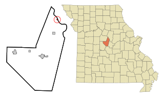
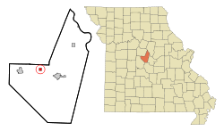
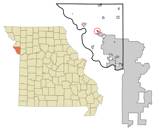
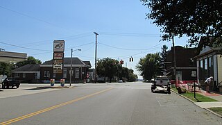
Lupus is a city in Moniteau County, Missouri, United States. The population was 28 at the 2020 census. It is part of the Jefferson City metropolitan area.

<span class="mw-page-title-main">Tipton, Missouri</span> City in Missouri, United States

Tipton is a city in Moniteau County, Missouri, United States. The population was 2,920 as of the 2020 census, down from 3,262 in 2010. It is part of the Jefferson City metropolitan area.

<span class="mw-page-title-main">Hayti Heights, Missouri</span> City in Missouri, United States

Hayti Heights is a city in eastern Pemiscot County in the bootheel of southeast Missouri, United States. The population was 515 at the 2020 census.

<span class="mw-page-title-main">Tracy, Missouri</span> City in Missouri, United States

Tracy is a city in Platte County, Missouri within the United States, located along the Platte River. The population was 269 at the 2020 census. The city is part of the Kansas City metropolitan area.

<span class="mw-page-title-main">Higbee, Missouri</span> City in Missouri, United States

Higbee is a city in southern Randolph County, Missouri, United States. The population was 568 at the 2010 census. Barrel-making company A&K Cooperage, Barrel 53 Cooperage and Woodsmen Distilling are based in Higbee.

<span class="mw-page-title-main">Nelson, Missouri</span> City in Missouri, United States

Nelson is a city in Saline County, Missouri, United States. The population was 152 at the 2020 census.

<span class="mw-page-title-main">Greendale, Missouri</span> City in Missouri, United States

Greendale is a city in St. Louis County, Missouri, United States. The population was 651 at the 2010 census.

<span class="mw-page-title-main">Lakeshire, Missouri</span> City in Missouri, United States

Lakeshire is a city in St. Louis County, Missouri, United States. The population was 1,432 at the 2010 census.

<span class="mw-page-title-main">Manchester, Missouri</span> City in Missouri, United States

Manchester is a city in St. Louis County, Missouri, United States. The population was 18,333 at the 2020 census.

<span class="mw-page-title-main">Velda City, Missouri</span> City in Missouri, United States

Velda City is a city in St. Louis County, Missouri, United States. The population was 1,420 at the 2010 census.

<span class="mw-page-title-main">Prairie Home, Missouri</span> City in Missouri, United States

Prairie Home is a city, in Cooper County, Missouri, United States. The population was 280 at the 2010 census.

<span class="mw-page-title-main">Clarkson Valley, Missouri</span> City in Missouri, United States

Clarkson Valley is a city in St. Louis County, Missouri, United States. The population was 2,609 at the 2020 census.

<span class="mw-page-title-main">Clarksburg, Ohio</span> Village in Ohio, United States

Clarksburg is a village in Ross County, Ohio, United States. The population was 409 at the 2020 census.

<span class="mw-page-title-main">Cherry Township, Butler County, Pennsylvania</span> Township in Pennsylvania, United States

Cherry Township is a township in Butler County, Pennsylvania, United States. The population was 1,106 at the 2010 census.

<span class="mw-page-title-main">Anmoore, West Virginia</span> Town in West Virginia, United States

Anmoore is a town in Harrison County, West Virginia, United States. It is located at the intersection of WV 58 and Interstate 79. The population was 514 at the 2020 census.

References

  1. 1 2 "2023 U.S. Gazetteer Files: Missouri". United States Census Bureau. Retrieved April 29, 2024.
  2. 1 2 U.S. Geological Survey Geographic Names Information System: Clarksburg, Missouri
  3. 1 2 "P1. Race – Clarksburg city, Missouri: 2020 DEC Redistricting Data (PL 94-171)". U.S. Census Bureau. Retrieved April 29, 2024.
  4. 1 2 "U.S. Census website". United States Census Bureau . Retrieved January 31, 2008.
  5. "Post Offices". Jim Forte Postal History. Retrieved November 10, 2016.
  6. Eaton, David Wolfe (1917). How Missouri Counties, Towns and Streams Were Named. The State Historical Society of Missouri. pp.  333.
  7. "Moniteau County Place Names, 1928–1945". The State Historical Society of Missouri. Archived from the original on June 24, 2016. Retrieved November 10, 2016.
  8. "Census of Population and Housing". Census.gov. Retrieved June 4, 2015.
  9. "U.S. Census website". United States Census Bureau . Retrieved July 8, 2012.