Related Research Articles
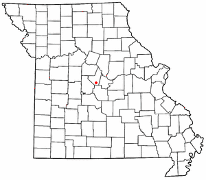
High Point is an unincorporated community in southern Moniteau County, Missouri, United States. It is located ten miles south of California, approximately one mile west of Route 87 on Missouri Route C.

NOTE: Cedar Township in Callaway County no longer contains the town of Cedar City since boundary changes creating Summit Township from its former southern sector sometime between 1883 and 1897. This has caused some confusion in historical, geographic, and genealogical research—see "History" section below.

Round Prairie Township is one of eighteen townships in Callaway County, Missouri, USA. As of the 2010 census, its population was 1038.

Clark Fork Township is one of fourteen townships in Cooper County, Missouri, USA. As of the 2000 census, its population was 598.

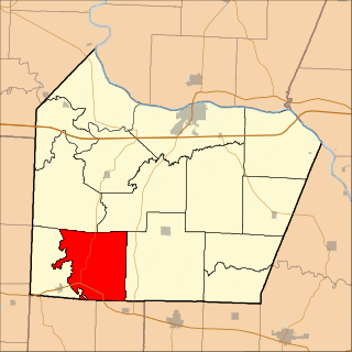
Boonville Township is one of fourteen townships in Cooper County, Missouri, USA. As of the 2000 census, its population was 9,898.

Lamine Township is one of 14 civil townships in Cooper County, in the U.S. state of Missouri. Twenty-two of Missouri's 114 counties, including Cooper County, have civil township governments. The other 92 counties have townships which are geographical but not governmental (civil). According to the 1860 Census, the population of Lamine Township was 830 . As of the 2020 Census, Lamine Township's population was 257.
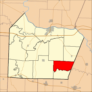
Lebanon Township is one of fourteen townships in Cooper County, Missouri, USA. As of the 2000 census, its population was 333.
North Moniteau Township is one of fourteen townships in Cooper County, Missouri, USA. As of the 2000 census, its population was 182.

Saline Township is one of fourteen townships in Cooper County, Missouri, USA. As of the 2000 census, its population was 687.
Marion is an unincorporated community in Cole County, Missouri, United States. Marion is in the northwest corner of the county, in historic Marion Township, and very near the post-1845 county boundary line with Moniteau County. The community is located on Missouri Route 179 and overlooks the Missouri River to the east.
Moniteau Creek is a stream in Randolph, Howard and Boone counties in the U.S. state of Missouri. The headwaters of the stream are southwest of Moberly in Randolph County. The stream flows south passing into Howard County in the Rudolph Bennett Conservation Area. The stream flows south-southwest along the eastern part of the county passing under Missouri Route 124 and becomes the boundary between Howard and Boone counties before passing under U. S. Route 40 and entering the Missouri River just south of Rocheport.
Wilton is an unincorporated community in southwest Boone County, in the U.S. state of Missouri. The community is on the northeast bank of the Missouri River across from the Marion Bottoms Conservation Area. Ashland lies approximately six miles to the northeast on Missouri Route M and Sandy Hook lies across the Missouri three miles to the west in Moniteau County. The lone business in Wilton is the Riverview Store, which serves the local community and users on the Katy Trail.
Moniteau Creek is a stream in Cooper, Moniteau and Cole counties in central Missouri. It is a tributary of the Missouri River. The stream headwaters are in western Moniteau County just west of Tipton. The stream flows north into Cooper County then turns east and flows through the southeastern part of the county and re-enters Moniteau County. The stream continues meandering east passing under Missouri Route 87 south of Jamestown and enters the Missouri River floodplain in the Marion Bottoms Conservation Area between Sandy Hook to the north and Marion to the south. The confluence with the Missouri River floodplain lies in the northern tip of Cole County.
Sandy Hook is an unincorporated community in Moniteau County, in the U.S. state of Missouri. The community is on the southwest bank of the Missouri River floodplain. It lies on Missouri Route 179 between Jamestown to the northwest and Marion to the southeast in Cole County.
Burris Fork Township is an inactive township in Moniteau County, in the U.S. state of Missouri.
Harrison Township is an inactive township in Moniteau County, in the U.S. state of Missouri.
Moreau Township is an inactive township in Moniteau County, in the U.S. state of Missouri.
Pilot Grove Township is an inactive township in Moniteau County, in the U.S. state of Missouri.
Walker Township is an inactive township in Moniteau County, in the U.S. state of Missouri.
Willow Fork Township is a township in Moniteau County, in the U.S. state of Missouri.
References
- ↑ U.S. Geological Survey Geographic Names Information System: Linn Township, Moniteau County, Missouri
- ↑ "Moniteau County Place Names, 1928–1945". The State Historical Society of Missouri. Archived from the original on June 24, 2016. Retrieved November 10, 2016.
Municipalities and communities of Moniteau County, Missouri, United States | ||
|---|---|---|
| Cities |  | |
| Village | ||
| Townships | ||
| CDPs | ||
| Other communities | ||
38°47′11″N92°29′18″W / 38.7864°N 92.4883°W
| | This Moniteau County, Missouri state location article is a stub. You can help Wikipedia by expanding it. |