Tipton, Missouri

Last updated

Tipton, Missouri
Tipton, Missouri on March 31 2019.jpg
Downtown Tipton
Moniteau County Missouri Incorporated and Unincorporated areas Tipton Highlighted.svg
Location in Moniteau County and the state of Missouri
Usa edcp location map.svg
Red pog.svg
Tipton, Missouri
Location in US
Coordinates: 38°39′18″N92°46′49″W / 38.65500°N 92.78028°W / 38.65500; -92.78028 [1]
Country United States
State Missouri
County Moniteau
Named for William Tipton Seely
Government
   Mayor Joe Lutz
Area
[2]
  Total2.11 sq mi (5.46 km2)
  Land2.09 sq mi (5.42 km2)
  Water0.02 sq mi (0.05 km2)
Elevation
[1]
929 ft (283 m)
Population
 (2020) [3]
  Total2,920
  Density1,396.46/sq mi (539.10/km2)
Time zone UTC-6 (Central (CST))
  Summer (DST) UTC-5 (CDT)
ZIP code
65081
Area code 660
FIPS code 29-73420 [4]
GNIS feature ID2397030 [1]
U.S. Routes US 50.svg
State highways MO-5.svg
Website www.tiptonmo.us

Tipton is a city in Moniteau County, Missouri, United States. The population was 2,920 as of the 2020 census, [3] down from 3,262 in 2010. It is part of the Jefferson City metropolitan area.

Contents

History

Tipton was a predominantly German-American community, in the region known as the Missouri Weinstrasse. [5] Tipton was an eastern terminus of the Butterfield Overland Mail when it was launched in 1858. The route was connected to St. Louis by the Pacific Railroad. Tipton is named for William Tipton Seely, a businessman in nearby Round Hill. He received the land for his service in the War of 1812. [6] [7] From Tipton, a stage went to Fort Smith, Arkansas (where another branch from Memphis also entered). From there, it went on to Los Angeles and San Francisco via a route through southern Arizona and New Mexico. The first run went from Tipton to San Francisco from September 16 to October 10, 1858. The route antedated the Pony Express by two years. Per a 2009 Congressional mandate, the National Park Service is studying whether to designate the route a National Historic Trail. [8]

The Maclay Mansion was listed on the National Register of Historic Places in 1979. [9]

Tipton 8 Ball Water Tower

The city of Tipton has a water tower painted like an "eight-ball". The tower originated in 1968, when Ewald Fischer (a native of Tipton) built his billiard table factory—Fischer Manufacturing Co., which claimed to be the largest builder of pool tables in the United States. The company was purchased by the Spalding Company, and the plant closed when Spalding sold it in 1976 to Ebonite Billiard, which was a subsidiary of Fuqua Companies. By then, the water tower was repainted. However, the residents of Tipton wanted to have the eight-ball back, so it was painted again. Today, the water tower is generally regarded as the world's largest eight-ball. [10]

Geography

Tipton is located in western Moniteau County at the intersection of U.S. Route 50 and Missouri Route 5. It is 12 miles (19 km) west of California, the Moniteau county seat, and 5 miles (8 km) east of Syracuse in adjacent Morgan County. Versailles is 17 miles (27 km) south on Route 5 in Morgan County. [11]

According to the U.S. Census Bureau, Tipton has a total area of 2.11 square miles (5.46 km2), of which 2.09 square miles (5.41 km2) are land and 0.02 square miles (0.05 km2), or 0.85%, are water. [2] The city is on high ground which drains north to Smiley Creek, which runs northeast to Moniteau Creek; and south towards Willow Fork, which runs east to North Moreau Creek and is part of the Moreau River watershed. Moniteau Creek and the Moreau River each run east to the Missouri River.

Demographics

Historical population
CensusPop.Note
1880 989
1890 1,25326.7%
1900 1,3376.7%
1910 1,273−4.8%
1920 1,170−8.1%
1930 1,067−8.8%
1940 1,21914.2%
1950 1,2341.2%
1960 1,63932.8%
1970 1,91416.8%
1980 2,15512.6%
1990 2,026−6.0%
2000 3,26161.0%
2010 3,2620.0%
2020 2,920−10.5%
U.S. Decennial Census [12]

2010 census

As of the census [13] of 2010, there were 3,262 people, 876 households, and 558 families residing in the city. The population density was 1,560.8 inhabitants per square mile (602.6/km2). There were 999 housing units at an average density of 478.0 per square mile (184.6/km2). The racial makeup of the city was 82.0% White, 16.0% African American, 0.4% Native American, 0.5% Asian, 0.2% from other races, and 0.9% from two or more races. Hispanic or Latino of any race were 1.3% of the population.

There were 876 households, of which 32.3% had children under the age of 18 living with them, 50.9% were married couples living together, 9.4% had a female householder with no husband present, 3.4% had a male householder with no wife present, and 36.3% were non-families. 32.9% of all households were made up of individuals, and 14.9% had someone living alone who was 65 years of age or older. The average household size was 2.34 and the average family size was 2.96.

The median age in the city was 38.4 years. 16.4% of residents were under the age of 18; 7.7% were between the ages of 18 and 24; 37.6% were from 25 to 44; 25.7% were from 45 to 64; and 12.6% were 65 years of age or older. The gender makeup of the city was 65.1% male and 34.9% female.

2000 census

As of the census [4] of 2000, there were 3,261 people, 872 households, and 558 families residing in the city. The population density was 1,554.6 inhabitants per square mile (600.2/km2). There were 967 housing units at an average density of 461.0 per square mile (178.0/km2). The racial makeup of the city was 81.51% White, 15.18% African American, 0.95% Native American, 0.43% Asian, 0.03% Pacific Islander, 0.28% from other races, and 1.63% from two or more races. Hispanic or Latino of any race were 0.89% of the population.

There were 872 households, out of which 31.8% had children under the age of 18 living with them, 49.5% were married couples living together, 10.8% had a female householder with no husband present, and 36.0% were non-families. 32.3% of all households were made up of individuals, and 19.5% had someone living alone who was 65 years of age or older. The average household size was 2.33 and the average family size was 2.94.

In the city, the population was spread out, with 16.8% under the age of 18, 7.9% from 18 to 24, 43.5% from 25 to 44, 17.8% from 45 to 64, and 14.0% who were 65 years of age or older. The median age was 37 years. For every 100 females, there were 188.3 males. For every 100 females age 18 and over, there were 215.8 males.

The median income for a household in the city was $32,155, and the median income for a family was $40,486. Males had a median income of $24,509 versus $20,824 for females. The per capita income for the city was $15,987. About 8.7% of families and 10.2% of the population were below the poverty line, including 13.5% of those under age 18 and 10.5% of those age 65 or over.

Education

Public education in Tipton is administered by Tipton R-VI School District. [14]

Tipton has a public library, Price James Memorial Library recognized by the State Library, managed by the Tipton Municipal Library Board established with a voter-approved property tax in 2017. The trustees are appointed by the Mayor of Tipton with approval of the Tipton City Council.

Missouri Training School for Negro Girls, a juvenile correctional facility for black girls operated by the Missouri State Board of Training Schools, was located in Tipton. It opened in 1926 and closed in 1956. It consolidated into the Missouri Training School for Girls in Chillicothe. [15]

Notable people

Related Research Articles

<span class="mw-page-title-main">Morgan County, Missouri</span> County in Missouri, United States

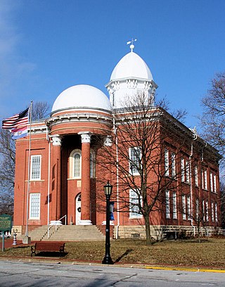
Morgan County is a county located in the central portion of the U.S. state of Missouri. As of the 2020 census, the population was 21,006. Its county seat is Versailles. The county was organized January 5, 1833, and named for General Daniel Morgan of the American Revolutionary War.

<span class="mw-page-title-main">Moniteau County, Missouri</span> County in Missouri, United States

Moniteau County is a county located in the U.S. state of Missouri. As of the 2020 United States census, the population was 15,473. Its county seat is California. The county was organized February 14, 1845, and named for the Moniteau Creek. 'Moniteau' is a French spelling of Manitou, Algonquian for the Great Spirit.

<span class="mw-page-title-main">Maries County, Missouri</span> County in Missouri, United States

Maries County is a county located in the U.S. state of Missouri. As of the 2020 census, its population was 8,432. Its county seat is Vienna. The county was organized March 2, 1855, and named for the Maries River and Little Maries River. The word "Maries" is derived from the French word marais, which means "marsh, lake, or pond".

<span class="mw-page-title-main">Cooper County, Missouri</span> County in Missouri, United States

Cooper County is located in the central portion of the U.S. state of Missouri. As of the 2020 United States census, the population was 17,103. Its county seat is Boonville. The county was organized December 17, 1818, and named for Sarshell Cooper, a frontier settler who was killed by Native Americans near Arrow Rock in 1814. It is a part of the Columbia, Missouri metropolitan area.

<span class="mw-page-title-main">Tipton, Kansas</span> City in Mitchell County, Kansas

Tipton is a city in Mitchell County, Kansas, United States. As of the 2020 census, the population of the city was 193.

<span class="mw-page-title-main">Harrisburg, Missouri</span> Village in Missouri, United States

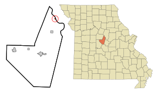
Harrisburg is a village in western Boone County, Missouri, United States. It is part of the Columbia, Missouri Metropolitan Statistical Area. The population was 266 at the 2010 census.

<span class="mw-page-title-main">Rocheport, Missouri</span> City in Missouri, United States

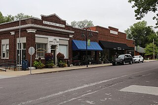
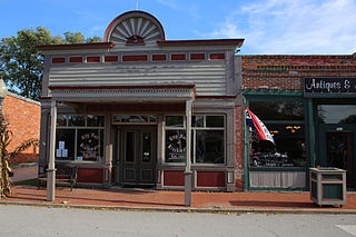
Rocheport is a city in Boone County, Missouri, United States. It is part of the Columbia, Missouri Metropolitan Statistical Area. The population was 239 at the 2010 census. Rocheport includes the Rocheport Historic District, an area with buildings dating from 1830 and which is listed on the National Register of Historic Places.

<span class="mw-page-title-main">Blackwater, Missouri</span> City in Missouri, United States

Blackwater is a city in northwest Cooper County, Missouri, United States located along the Blackwater River, from which it takes its name. The population was 162 at the 2010 census.

<span class="mw-page-title-main">Otterville, Missouri</span> City in Missouri, United States

Otterville is a city in southwest Cooper County, Missouri, United States. The population was 454 at the 2010 census.

<span class="mw-page-title-main">Ethel, Missouri</span> Town in Missouri, United States

Ethel is a town in Macon County, Missouri, United States. The population was 41 at the 2020 census, down from 62 in 2010.

<span class="mw-page-title-main">Clarksburg, Missouri</span> City in Missouri, United States

Clarksburg is a city in Moniteau County, Missouri, United States. The population was 254 at the 2020 census, down from 334 in 2010. It is part of the Jefferson City metropolitan area.

<span class="mw-page-title-main">Jamestown, Missouri</span> Town in Missouri, United States

Jamestown is a village in northeastern Moniteau County, Missouri, United States. The population was 330 at the 2020 census, down from 386 in 2010. It is part of the Jefferson City metropolitan area.

<span class="mw-page-title-main">Lupus, Missouri</span> City in Missouri, United States

Lupus is a city in Moniteau County, Missouri, United States. The population was 28 at the 2020 census. It is part of the Jefferson City metropolitan area.

<span class="mw-page-title-main">Chamois, Missouri</span> City in Missouri, United States

Chamois is a city in Osage County, Missouri, United States. The population was 377 at the 2020 census. It is part of the Jefferson City, Missouri Metropolitan Statistical Area.

<span class="mw-page-title-main">Hayti Heights, Missouri</span> City in Missouri, United States

Hayti Heights is a city in eastern Pemiscot County in the bootheel of southeast Missouri, United States. The population was 515 at the 2020 census.

<span class="mw-page-title-main">Higbee, Missouri</span> City in Missouri, United States

Higbee is a city in southern Randolph County, Missouri, United States. The population was 568 at the 2010 census. Barrel-making company A&K Cooperage, Barrel 53 Cooperage and Woodsmen Distilling are based in Higbee.

<span class="mw-page-title-main">Grant City, Missouri</span> City in Missouri, United States

Grant City is a city in, and the county seat of, Worth County, Missouri, United States. The population was 817 at the 2020 census.

<span class="mw-page-title-main">Prairie Home, Missouri</span> City in Missouri, United States

Prairie Home is a city, in Cooper County, Missouri, United States. The population was 280 at the 2010 census.

<span class="mw-page-title-main">Forsyth, Missouri</span> City in Missouri, United States

Forsyth is a city in Taney County, Missouri, United States. The population was 2,730 at the 2020 census. It is the county seat of Taney County. The town is part of the Branson, Missouri Micropolitan Statistical Area. Forsyth is located on Lake Taneycomo on U.S. Route 160.

Gilt Edge is a city in Tipton County, Tennessee. The population was 477 at the 2010 census and 456 in 2018, showing a decrease of 21.

References

  1. 1 2 3 U.S. Geological Survey Geographic Names Information System: Tipton, Missouri
  2. 1 2 "2023 U.S. Gazetteer Files: Missouri". United States Census Bureau. Retrieved April 29, 2024.
  3. 1 2 "P1. Race – Tipton city, Missouri: 2020 DEC Redistricting Data (PL 94-171)". U.S. Census Bureau. Retrieved April 29, 2024.
  4. 1 2 "U.S. Census website". United States Census Bureau . Retrieved January 31, 2008.
  5. Nomura, Gabrielle (March 29, 2011). "David Koechner | Underneath the cowboy hat and outside 'The Office'". Bellevue Reporter. Retrieved May 15, 2019.
  6. "The Founding of Tipton". www.tiptonmo.com. Archived from the original on November 12, 1999.
  7. Eaton, David Wolfe (1917). How Missouri Counties, Towns and Streams Were Named. The State Historical Society of Missouri. pp.  333.
  8. "Butterfield Overland Mail". www.tiptonmo.com. Archived from the original on November 18, 1999.
  9. "National Register Information System". National Register of Historic Places . National Park Service. July 9, 2010.
  10. "8 Ball Water Tower". www.tiptonmo.com. Archived from the original on October 11, 2000.
  11. Missouri Atlas & Gazetteer, DeLorme, 1998, First edition, p. 37, ISBN   0-89933-224-2
  12. "Census of Population and Housing". Census.gov. Retrieved June 4, 2015.
  13. "U.S. Census website". United States Census Bureau . Retrieved July 8, 2012.
  14. "Homepage". Tipton R-Vi School District. Retrieved June 5, 2019.
  15. "Annual Report Fiscal Year 2014" (Archive). Missouri Division of Youth Services. Retrieved on December 19, 2015. p. 32.
  16. Miller, Gregg (2004). Going… Going… Nuts!: The Story Had to Be Told…. PublishAmerica. ISBN   978-1-4137-5316-5.
  17. Garcia, Oskar (November 3, 2012). "Edwin Q. White, former AP Saigon chief, dies". Hawaii Tribune Herald . Archived from the original on January 3, 2013. Retrieved November 22, 2012.