Jamestown, Missouri

Last updated

Jamestown, Missouri
Moniteau County Missouri Incorporated and Unincorporated areas Jamestown Highlighted.svg
Location in Moniteau County and the state of Missouri
Coordinates: 38°46′00″N92°28′49″W / 38.76667°N 92.48028°W / 38.76667; -92.48028 [1]
Country United States
State Missouri
County Moniteau
Founded1846
Incorporated1850
Named for E.H. and S.L. James
Area
[2]
  Total1.01 sq mi (2.61 km2)
  Land1.00 sq mi (2.59 km2)
  Water0.01 sq mi (0.02 km2)
Elevation
[1]
869 ft (265 m)
Population
 (2020) [3]
  Total330
  Density330.33/sq mi (127.48/km2)
Time zone UTC-6 (Central (CST))
  Summer (DST) UTC-5 (CDT)
ZIP code
65046
Area code 660
FIPS code 29-36368 [4]
GNIS feature ID2397011 [1]

Jamestown is a village in northeastern Moniteau County, Missouri, United States. The population was 330 at the 2020 census, [3] down from 386 in 2010. It is part of the Jefferson City metropolitan area.

Contents

History

Jamestown had its start in 1846 when E. H. and S. L. James established a country store at that point. [5] [6] A post office called Jamestown has been in operation since 1850. [7]

The Assumption of the Blessed Virgin Mary Parish Historic District and Dick-Kobel Homestead are listed on the National Register of Historic Places in Jamestown. [8] [9]

Geography

The village is located on Missouri Route 87, approximately 12 miles (19 km) northeast of California, the county seat. Sandy Hook, on the Missouri River, is 4 miles (6 km) east on Missouri Route 179. [10]

According to the U.S. Census Bureau, Jamestown has a total area of 1.01 square miles (2.62 km2), of which 0.01 square miles (0.03 km2), or 0.70%, are water. [2] The village sits on a ridge which drains north toward Factory Creek, southeast into Haldiman Branch, and southwest into Hauck Branch. Factory Creek is an east-flowing direct tributary of the Missouri River, while the two branches flow southeast to Moniteau Creek, also a tributary of the Missouri.

Demographics

Historical population
CensusPop.Note
1880 185
1890 31369.2%
1900 3449.9%
1910 305−11.3%
1920 264−13.4%
1930 2733.4%
1940 269−1.5%
1950 245−8.9%
1960 216−11.8%
1970 24312.5%
1980 31730.5%
1990 298−6.0%
2000 38228.2%
2010 3861.0%
2020 330−14.5%
U.S. Decennial Census [11]

2010 census

As of the census [12] of 2010, there were 386 people, 161 households, and 100 families residing in the village. The population density was 386.0 inhabitants per square mile (149.0/km2). There were 187 housing units at an average density of 187.0 per square mile (72.2/km2). The racial makeup of the village was 97.9% White and 2.1% from two or more races. Hispanic or Latino of any race were 1.0% of the population.

There were 161 households, of which 34.2% had children under the age of 18 living with them, 48.4% were married couples living together, 11.2% had a female householder with no husband present, 2.5% had a male householder with no wife present, and 37.9% were non-families. 36.6% of all households were made up of individuals, and 18.6% had someone living alone who was 65 years of age or older. The average household size was 2.40 and the average family size was 3.16.

The median age in the village was 36.6 years. 28.5% of residents were under the age of 18; 5.7% were between the ages of 18 and 24; 24.3% were from 25 to 44; 22% were from 45 to 64; and 19.4% were 65 years of age or older. The gender makeup of the village was 49.2% male and 50.8% female.

2000 census

As of the census [4] of 2000, there were 382 people, 175 households, and 103 families residing in the town. The population density was 381.2 inhabitants per square mile (147.2/km2). There were 191 housing units at an average density of 190.6 per square mile (73.6/km2). The racial makeup of the town was 97.12% White, 0.79% Native American, 0.26% Asian, 0.26% Pacific Islander, and 1.57% from two or more races. Hispanic or Latino of any race were 0.52% of the population.

There were 175 households, out of which 27.4% had children under the age of 18 living with them, 44.6% were married couples living together, 9.7% had a female householder with no husband present, and 40.6% were non-families. 36.0% of all households were made up of individuals, and 16.0% had someone living alone who was 65 years of age or older. The average household size was 2.18 and the average family size was 2.81.

In the town the population was spread out, with 23.0% under the age of 18, 8.9% from 18 to 24, 27.0% from 25 to 44, 24.3% from 45 to 64, and 16.8% who were 65 years of age or older. The median age was 38 years. For every 100 females, there were 94.9 males. For every 100 females age 18 and over, there were 86.1 males.

The median income for a household in the town was $31,667, and the median income for a family was $41,389. Males had a median income of $27,917 versus $20,461 for females. The per capita income for the town was $16,498. About 3.7% of families and 8.1% of the population were below the poverty line, including 10.6% of those under age 18 and 9.8% of those age 65 or over.

Education

There is one high school in Jamestown, Jamestown C-1 High School.

Related Research Articles

<span class="mw-page-title-main">Moniteau County, Missouri</span> County in Missouri, United States

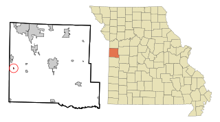
Moniteau County is a county located in the U.S. state of Missouri. As of the 2020 United States census, the population was 15,473. Its county seat is California. The county was organized February 14, 1845, and named for the Moniteau Creek. 'Moniteau' is a French spelling of Manitou, Algonquian for the Great Spirit.

<span class="mw-page-title-main">Merwin, Missouri</span> Village in Missouri, United States

Merwin is a village in Bates County, Missouri, and is part of the Kansas City metropolitan area within the United States. The population was 69 at the 2020 census.

<span class="mw-page-title-main">Harrisburg, Missouri</span> Village in Missouri, United States

Harrisburg is a village in western Boone County, Missouri, United States. It is part of the Columbia, Missouri Metropolitan Statistical Area. The population was 266 at the 2010 census.

<span class="mw-page-title-main">Rocheport, Missouri</span> City in Missouri, United States

Rocheport is a city in Boone County, Missouri, United States. It is part of the Columbia, Missouri Metropolitan Statistical Area. The population was 239 at the 2010 census. Rocheport includes the Rocheport Historic District, an area with buildings dating from 1830 and which is listed on the National Register of Historic Places.

<span class="mw-page-title-main">West Line, Missouri</span> Village in Missouri, United States

West Line is a village in Cass County, Missouri. The population was 97 at the 2010 census. It is part of the Kansas City metropolitan area.

<span class="mw-page-title-main">Oakview, Missouri</span> Village in Missouri, United States

Oakview is a village in Clay County, Missouri, United States. The population was 366 at the 2020 census. It is part of the Kansas City metropolitan area.

<span class="mw-page-title-main">Big Lake, Missouri</span> Village in Missouri, United States

Big Lake is a village in Holt County, Missouri, United States. The population was 65 at the 2020 census.

<span class="mw-page-title-main">Airport Drive, Missouri</span> Village in Missouri, United States

Airport Drive is a village in Jasper County, Missouri, United States. The population was 766 at the 2020 census. It is part of the Joplin, Missouri Metropolitan Statistical Area. The community is still commonly referred to as "Stone's Corner," as the intersection of Route 43 and Route 171 is known.

<span class="mw-page-title-main">Clarksburg, Missouri</span> City in Missouri, United States

Clarksburg is a city in Moniteau County, Missouri, United States. The population was 254 at the 2020 census, down from 334 in 2010. It is part of the Jefferson City metropolitan area.

<span class="mw-page-title-main">Lupus, Missouri</span> City in Missouri, United States

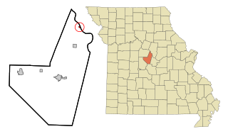
Lupus is a city in Moniteau County, Missouri, United States. The population was 28 at the 2020 census. It is part of the Jefferson City metropolitan area.

<span class="mw-page-title-main">Tipton, Missouri</span> City in Missouri, United States

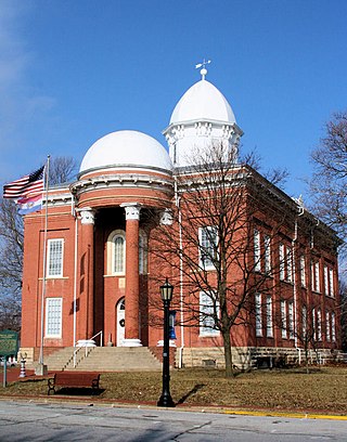
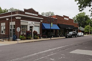
Tipton is a city in Moniteau County, Missouri, United States. The population was 2,920 as of the 2020 census, down from 3,262 in 2010. It is part of the Jefferson City metropolitan area.

<span class="mw-page-title-main">Cliff Village, Missouri</span> Village in Missouri, United States

Cliff Village is a village in Newton County, Missouri, United States. The population was 40 at the 2010 census. It is part of the Joplin, Missouri Metropolitan Statistical Area.

<span class="mw-page-title-main">Green Ridge, Missouri</span> City in Missouri, United States

Green Ridge is a city located along Route 127 in Pettis County, Missouri, United States. The population was 476 at the 2010 census.

<span class="mw-page-title-main">Flemington, Missouri</span> Village in Missouri, United States

Flemington is a village in Polk County, Missouri, United States. The population was 148 at the 2010 census. It is part of the Springfield, Missouri Metropolitan Statistical Area.

<span class="mw-page-title-main">Higbee, Missouri</span> City in Missouri, United States

Higbee is a city in southern Randolph County, Missouri, United States. The population was 568 at the 2010 census. Barrel-making company A&K Cooperage, Barrel 53 Cooperage and Woodsmen Distilling are based in Higbee.

<span class="mw-page-title-main">Grantwood Village, Missouri</span> Town in Missouri, United States

Grantwood Village is a town in St. Louis County, Missouri, United States. The population was 863 at the 2010 census.

<span class="mw-page-title-main">Winchester, Missouri</span> City in Missouri, United States

Winchester is a city in St. Louis County, Missouri, United States. The population was 1,447 at the 2020 census.

<span class="mw-page-title-main">Prairie Home, Missouri</span> City in Missouri, United States

Prairie Home is a city, in Cooper County, Missouri, United States. The population was 280 at the 2010 census.

<span class="mw-page-title-main">Uplands Park, Missouri</span> Village in Missouri, United States

Uplands Park is a village in St. Louis County, Missouri, United States. The population was 445 at the 2010 census. The village is one of many small majority black communities located in the Natural Bridge corridor of mid-St. Louis County, characterized by small homes on small lots.

<span class="mw-page-title-main">Jamestown, Ohio</span> Village in Ohio, United States

Jamestown is a village in Greene County, Ohio, United States. The population was 2,052 at the 2020 census.

References

  1. 1 2 3 U.S. Geological Survey Geographic Names Information System: Jamestown, Missouri
  2. 1 2 "2023 U.S. Gazetteer Files: Missouri". United States Census Bureau. Retrieved April 29, 2024.
  3. 1 2 "P1. Race – Jamestown village, Missouri: 2020 DEC Redistricting Data (PL 94-171)". U.S. Census Bureau. Retrieved April 29, 2024.
  4. 1 2 "U.S. Census website". United States Census Bureau . Retrieved January 31, 2008.
  5. Eaton, David Wolfe (1917). How Missouri Counties, Towns and Streams Were Named. The State Historical Society of Missouri. pp.  333.
  6. "Moniteau County Place Names, 1928–1945". The State Historical Society of Missouri. Archived from the original on June 24, 2016. Retrieved November 10, 2016.
  7. "Post Offices". Jim Forte Postal History. Retrieved November 10, 2016.
  8. "National Register Information System". National Register of Historic Places . National Park Service. July 9, 2010.
  9. "National Register of Historic Places Listings". Weekly List of Actions Taken on Properties: 2/03/14 through 2/07/14. National Park Service. February 14, 2014.
  10. Missouri Atlas & Gazetteer, DeLorme, 1998, First edition, p. 37, ISBN   0-89933-224-2
  11. "Census of Population and Housing". Census.gov. Retrieved June 4, 2015.
  12. "U.S. Census website". United States Census Bureau . Retrieved July 8, 2012.