
Dewey County is a county in the U.S. state of South Dakota. As of the 2020 census, the population was 5,239. Its county seat is Timber Lake. The county was created in 1883 and organized in 1910. It was named for William P. Dewey, Territorial surveyor-general from 1873 to 1877.

Morgan County is a county located in the central portion of the U.S. state of Missouri. As of the 2020 census, the population was 21,006. Its county seat is Versailles. The county was organized January 5, 1833, and named for General Daniel Morgan of the American Revolutionary War.
Moniteau County is a county located in the U.S. state of Missouri. As of the 2020 United States census, the population was 15,473. Its county seat is California. The county was organized February 14, 1845, and named for the Moniteau Creek. 'Moniteau' is a French spelling of Manitou, Algonquian for the Great Spirit.

Harrisburg is a village in western Boone County, Missouri, United States. It is part of the Columbia, Missouri Metropolitan Statistical Area. The population was 266 at the 2010 census.

Cedar Hill is an unincorporated community and census-designated place (CDP) in northwest Jefferson County, Missouri, United States. The population was 1,721 at the 2010 census.

High Ridge is an unincorporated community and census-designated place (CDP) in Jefferson County, Missouri, United States. The population was 4,305 at the 2010 census. At 927 feet (283 m) above sea level, High Ridge is the second-highest point in Jefferson County, second only to Sun Ridge, north of Hillsboro, according to data from the House Springs/Hillsboro 7.5 minute topographic quadrangles. The Beaumont Scout Reservation, a property of the Greater St. Louis Area Council, Boy Scouts of America, is 4 miles (6 km) north of High Ridge.

Horine is an unincorporated community and census-designated place (CDP) in Jefferson County, Missouri, United States. The population was 821 at the 2010 census, down from 923 in 2000.

Eldon is a city in Miller County, Missouri, United States, located 30 miles (48 km) southwest of Jefferson City. The population was 4,416 as of the 2020 census.

Olean is a town in northern Miller County, Missouri, United States. The population was 114 at the 2020 census.

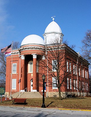
California is a city in and the county seat of Moniteau County, Missouri, United States. As of the 2020 census the population was 4,498. It is the largest city in Moniteau County and the third largest city in the Jefferson City metropolitan area.

Clarksburg is a city in Moniteau County, Missouri, United States. The population was 254 at the 2020 census, down from 334 in 2010. It is part of the Jefferson City metropolitan area.

Jamestown is a village in northeastern Moniteau County, Missouri, United States. The population was 330 at the 2020 census, down from 386 in 2010. It is part of the Jefferson City metropolitan area.
Lupus is a city in Moniteau County, Missouri, United States. The population was 28 at the 2020 census. It is part of the Jefferson City metropolitan area.

Tipton is a city in Moniteau County, Missouri, United States. The population was 2,920 as of the 2020 census, down from 3,262 in 2010. It is part of the Jefferson City metropolitan area.
Rocky Comfort is an unincorporated community and census-designated place in McDonald County, Missouri, United States, on Missouri Route 76. As of the 2020 census, it had a population of 176.
Dawn is an unincorporated community and census-designated place (CDP) in Livingston County, Missouri, United States. As of the 2020 census it had a population of 100.
Philadelphia is an unincorporated community and census-designated place in western Marion County, Missouri, United States. It is located 12 miles (19 km) west of Palmyra on Missouri Route 168. The community is part of the Hannibal Micropolitan Statistical Area.
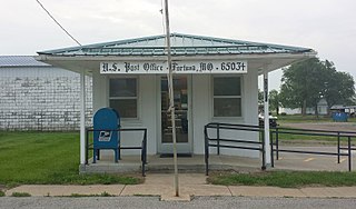
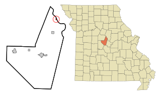
Fortuna is an unincorporated community and census-designated place in Moniteau County, Missouri, United States. As of the 2020 census, the population was 130.
Excello is an unincorporated community and census-designated place (CDP) in southern Macon County, Missouri, United States. As of the 2020 United States census, it had a population of 61.
Cherokee Pass is an unincorporated community and census-designated place in Madison County, Missouri, United States. As of the 2020 census, it had a population of 271, up from 235 in 2010.


