
Charleston is a city in and the county seat of Coles County, Illinois, United States. The population was 21,838, as of the 2010 census. The city is home to Eastern Illinois University and has close ties with its neighbor, Mattoon. Both are principal cities of the Charleston–Mattoon Micropolitan Statistical Area.

Columbia Township is a civil township of Tuscola County in the U.S. state of Michigan. The population was 1,284 at the 2010 Census.
Waddington is a town in St. Lawrence County, New York, United States. The population was 2,266 at the 2010 census. The town was named after its principal village.

In topography, prominence measures the height of a mountain or hill's summit relative to the lowest contour line encircling it but containing no higher summit within it. It is a measure of the independence of a summit. A peak's key col is a unique point on this contour line and the parent peak is some higher mountain, selected according to various criteria.

Coles Supermarkets Australia Pty Ltd, trading as Coles, is an Australian supermarket, retail and consumer services chain, headquartered in Melbourne as part of the Coles Group.
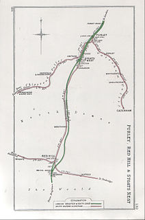
The Tattenham Corner line is a railway line in Southern England that runs between Purley in South London and Tattenham Corner in Surrey.

Australia Fair Shopping Centre is a dual-level regional shopping centre covering 59,540 square metres (640,900 sq ft) located in Southport, Gold Coast, Queensland. The centre also incorporates a five-level office tower comprising 5,824 square metres (62,690 sq ft) of office space, housing specialist services and commercial offices.

The Burnside Village shopping centre.
The South Croydon rail crash on the British railway system occurred on 24 October 1947.

Wollongong Central is a major shopping centre in the Illawarra region, located in the CBD of Wollongong, New South Wales approximately 90 kilometres south of Sydney. It is operated and managed by Australian property investment company, General Property Trust (GPT). It is of local importance and is used by much of the Illawarra community as a social and shopping centre. It is situated in the western half of the Crown Street Mall.

Coles Corner is the fourth studio album from English pop/rock musician Richard Hawley, released on 5 September 2005 in the UK and on 6 September 2005 in the US. The title immortalises the legendary Sheffield landmark Coles Corner, a popular meeting place of old and new lovers. The album was nominated for the 2006 Mercury Music Prize for best album.

Nye Mountain is a mountain located in Essex County, New York, named after William B. Nye (c.1815–1893), an Adirondack mountain guide. Nye Mountain is part of the Street Range of the Adirondack Mountains; it is flanked to the southwest by Street Mountain.

State Route 207 (SR 207) is a 4.38-mile-long (7.05 km) state highway serving Wenatchee National Forest and Lake Wenatchee State Park in Chelan County, located within the U.S. state of Washington. The highway travels north along Nason Creek from an intersection with U.S. Route 2 (US 2) at Coles Corner to Chiwawa Loop Road on the eastern shore of Lake Wenatchee. SR 207 was previously signed as part of Secondary State Highway 15C (SSH 15C) and SSH 15D until the 1964 highway renumbering, when SSH 15C was split between SR 207 and SR 209. SR 209 was removed from the highway system in 1991 and SR 207 was shortened to end at the former terminus of SR 209.

The Col. Frank J. Hecker House is a historic home that was built in 1888. It is located at 5510 Woodward Avenue in Midtown Detroit, Michigan.
Typeface anatomy describes the graphic elements that make up Font in a typeface.

On 5 January 1953, a Vickers Viking airliner operated by British European Airways crashed on approach to Belfast Nutts Corner Airport, Northern Ireland. The aircraft was on a domestic flight from London Northolt Airport with 31 passengers and 4 crew on board. Twenty-four of the passengers and three crew members died in the accident.

Speakers' Corner is an area located within Hong Lim Park, Singapore, where citizens and permanent residents of Singapore may demonstrate, hold exhibitions and performances, and speak freely on most topics after prior registration on a government website. Such activities are heavily restricted in other parts of Singapore.

The Canaan River is located in the southeastern portion of New Brunswick. The river drains into Washademoak Lake, in turn draining into the Saint John River. The watershed is composed of 17 tributaries. The total watershed area is 2,167 km2 (837 sq mi).
This page is based on this
Wikipedia article Text is available under the
CC BY-SA 4.0 license; additional terms may apply.
Images, videos and audio are available under their respective licenses.

