West Wenatchee, Washington

Last updated
West Wenatchee, Washington
Chelan County Washington Incorporated and Unincorporated areas West Wenatchee Highlighted.svg
Location of West Wenatchee, Washington
Coordinates: 47°26′16″N120°20′46″W / 47.43778°N 120.34611°W / 47.43778; -120.34611 Coordinates: 47°26′16″N120°20′46″W / 47.43778°N 120.34611°W / 47.43778; -120.34611
CountryUnited States
State Washington
County Chelan
Area
  Total4.1 sq mi (10.7 km2)
  Land4.0 sq mi (10.2 km2)
  Water0.2 sq mi (0.5 km2)
Elevation
889 ft (271 m)
Population
 (2000)
  Total1,681
  Density425.4/sq mi (164.2/km2)
Time zone UTC-8 (Pacific (PST))
  Summer (DST) UTC-7 (PDT)
ZIP code
98801
Area code 509
FIPS code 53-77910 [1]
GNIS feature ID1867647 [2]

West Wenatchee is a former census-designated place (CDP) and now an unincorporated community in Chelan County, Washington, United States. The United States Census Bureau removed the community at the 2010 census, with most of its former area being merged into Wenatchee city limits, raising the population significantly. [3] The area that was West Wenatchee is part of the Wenatchee East Wenatchee Metropolitan Statistical Area.

Contents

Geography

West Wenatchee is located at 47°26′16″N120°20′46″W / 47.43778°N 120.34611°W / 47.43778; -120.34611 (47.437855, -120.346030). [4]

According to the United States Census Bureau, the CDP had a total area of 4.1 square miles (10.7 km2), of which 4.0 square miles (10.2 km2) was land and 0.2 square miles (0.5 km2) (4.36%) was water, in 2000. This area was merged into that of Wenatchee's municipal boundaries at the 2010 census.

Demographics

As of the 2000 United States Census, there were 1,681 people, 628 households, and 509 families residing in the CDP. The population density was 425.4 people per square mile (164.3/km2). There were 661 housing units at an average density of 167.3/sq mi (64.6/km2). The racial makeup of the CDP was 93.75% White, 0.18% African American, 0.24% Native American, 1.07% Asian, 0.06% Pacific Islander, 3.45% from other races, and 1.25% from two or more races. Hispanic or Latino of any race were 8.09% of the population.

There were 628 households, out of which 32.5% had children under the age of 18 living with them, 70.7% were married couples living together, 7.0% had a female householder with no husband present, and 18.9% were non-families. 14.5% of all households were made up of individuals, and 5.3% had someone living alone who was 65 years of age or older. The average household size was 2.67 and the average family size was 2.94.

In the CDP, the age distribution of the population shows 25.3% under the age of 18, 6.5% from 18 to 24, 22.7% from 25 to 44, 29.6% from 45 to 64, and 15.9% who were 65 years of age or older. The median age was 43 years. For every 100 females, there were 95.5 males. For every 100 females age 18 and over, there were 97.2 males.

The median income for a household in the CDP was $44,028, and the median income for a family was $47,155. Males had a median income of $37,171 versus $23,750 for females. The per capita income for the CDP was $21,536. About 1.7% of families and 4.0% of the population were below the poverty line, including 6.2% of those under age 18 and none of those age 65 or over.

Related Research Articles

Chelan County, Washington U.S. county in Washington

Chelan County is a county in the U.S. state of Washington. As of the 2010 census, its population was 72,453. The county seat and largest city is Wenatchee. The county was created out of Okanogan and Kittitas Counties on March 13, 1899. It derives its name from a Chelan Indian word meaning "deep water," likely a reference to 55-mile (89 km)-long Lake Chelan, which reaches a maximum depth of 1,486 feet.

Parksdale, California census-designated place in California, United States

Parksdale is a census-designated place (CDP) in Madera County, California, United States. It is part of the Madera–Chowchilla Metropolitan Statistical Area. The population was 2,621 at the 2010 census, down from 2,688 at the 2000 census.

Tahoe Vista, California census-designated place in California, United States

Tahoe Vista is a census-designated place located on the north shore of Lake Tahoe in Placer County, California. It is part of the Sacramento–Arden-Arcade–Roseville Metropolitan Statistical Area. The population was 1,433 at the 2010 census, down from 1,668 at the 2000 census.

Eastover, North Carolina Town in North Carolina, United States

Eastover is a town in Cumberland County, North Carolina, United States. The population was 3,628 at the 2010 census. It was incorporated on July 25, 2007.

Inez, Texas CDP in Texas, United States

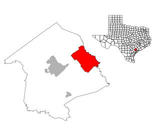
Inez is a census-designated place (CDP), on Interstate 69/U.S. Highway 59 fifteen miles northeast of Victoria, Texas, near the Jackson County, Texas line in Victoria County, Texas, United States. The population was 2,098 at the 2010 census. It is included in the Victoria, Texas, Metropolitan Statistical Area. The name is that of a daughter of a railroad developer.

Leisuretowne, New Jersey Census-designated place in New Jersey, United States

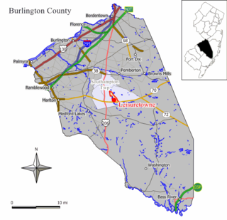
Leisuretowne is an unincorporated community and census-designated place (CDP) located within Southampton Township, in Burlington County, New Jersey, United States. As of the 2010 United States Census, the CDP's population was 3,582.

Chamberlayne, Virginia Census-designated place in Virginia

Chamberlayne is a census-designated place (CDP) in Henrico County, Virginia, United States. The population was 5,456 at the 2010 census.

South Wenatchee, Washington Census-designated place in Washington, United States

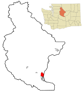
South Wenatchee is an unincorporated community and census-designated place (CDP) in Chelan County, Washington, United States. It is part of the Wenatchee–East Wenatchee Metropolitan Statistical Area. The population was 1,553 at the 2010 census.

Sunnyslope, Washington Census-designated place in Washington, United States

Sunnyslope is an unincorporated community and census-designated place (CDP) in Chelan County, Washington, United States. It is part of the Wenatchee–East Wenatchee Metropolitan Statistical Area. The population was 3,252 at the 2010 census, up from 2,521 at the 2000 census.

East Wenatchee Bench, Washington CDP in Washington, United States

East Wenatchee Bench is an unincorporated community in Douglas County, Washington, United States. Most of the area has been annexed by the city of East Wenatchee. It is part of the Wenatchee–East Wenatchee Metropolitan Statistical Area. The population was 13,658 at the 2000 census.

Rock Island, Washington City in Washington, United States

Rock Island is a city in Douglas County, Washington, United States. It is part of the Wenatchee–East Wenatchee Metropolitan Statistical Area. The population was 788 at the 2010 census.

Waterville, Washington Town in Washington, United States

Waterville is a town in and the county seat of Douglas County, Washington, United States which is known for its wheat industry. It is part of the Wenatchee-East Wenatchee metropolitan area. The population was 1,138 at the 2010 census.

Banks Lake South, Washington Census-designated place in Washington, United States

Banks Lake South is a census-designated place (CDP) in Grant County, Washington, United States. The population was 174 at the 2010 census.

Parkland, Washington Parkland is a CDP in Washington, United States

Parkland is a census-designated place (CDP) in Pierce County, Washington, United States. The population was 24,053 at the 2000 census and grew to 35,803 as of the 2010 census. It is an unincorporated suburb of the city of Tacoma and is home to Pacific Lutheran University.

Marblemount, Washington CDP in Washington, United States

Marblemount is a census-designated place in Skagit County, Washington, United States. The population was 203 at the 2010 census. It is included in the Mount Vernon–Anacortes, Washington Metropolitan Statistical Area.

Elkview, West Virginia Census-designated place in West Virginia, United States

Elkview is a census-designated place (CDP) in Kanawha County, West Virginia, United States. The population was 1,222 at the 2010 census. It is named after the Elk River, which flows into the Kanawha River.

Vista West, Wyoming CDP in Wyoming, United States

Vista West is a census-designated place (CDP) in Natrona County, Wyoming, United States. It is part of the Casper, Wyoming Metropolitan Statistical Area. The population was 951 at the 2010 census.

Brewster (CDP), Massachusetts Census-designated place in Massachusetts, United States

Brewster is a census-designated place (CDP) in the town of Brewster in Barnstable County, Massachusetts, United States. The population was 2,000 at the 2010 census, out of 9,820 in the town of Brewster as a whole.

Chatham (CDP), Massachusetts Census-designated place in Massachusetts, United States

Chatham is a census-designated place (CDP) in the town of Chatham in Barnstable County, Massachusetts, United States. The population was 1,421 at the 2010 census, out of 6,125 in the entire town of Chatham.

Altona (CDP), New York Census-designated place in New York, United States

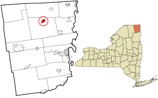
Altona is a hamlet and census-designated place (CDP) in the town of Altona, Clinton County, New York, United States. The population was 730 at the 2010 census, out of a total town population of 2,887.

References

  1. "U.S. Census website". United States Census Bureau . Retrieved 2008-01-31.
  2. "US Board on Geographic Names". United States Geological Survey. 2007-10-25. Retrieved 2008-01-31.
  3. "Washington: 2010 – Population and Housing Unit Counts" (PDF). United States Census Bureau. August 1, 2012. Retrieved July 12, 2013.
  4. "US Gazetteer files: 2010, 2000, and 1990". United States Census Bureau. 2011-02-12. Retrieved 2011-04-23.