
Chelan County is a county in the U.S. state of Washington. As of the 2020 census, its population was 79,074. The county seat and largest city is Wenatchee. The county was created out of Okanogan and Kittitas Counties on March 13, 1899. It derives its name from a Chelan Indian word meaning "deep water," likely a reference to 55-mile (89 km)-long Lake Chelan, which reaches a maximum depth of 1,486 feet.

Cashmere is a city in Chelan County, Washington, United States. It is part of the Wenatchee–East Wenatchee Metropolitan Statistical Area. The population was 3,060 at the 2010 census. The population was 3,157 at the 2018 estimates.

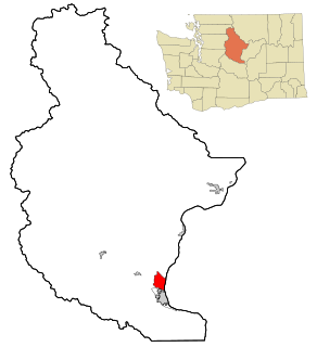
Chelan is a city in Chelan County, Washington, United States. The estimated population was 3,850 at the 2010 census with a margin of error of ±15. The population was 4,222 at 2018 Estimate from Office of Financial Management. It lies on the southeast tip of Lake Chelan, where the lake flows into the Chelan River.
Sunnyslope is an unincorporated community and census-designated place (CDP) in Chelan County, Washington, United States. It is part of the Wenatchee–East Wenatchee Metropolitan Statistical Area. The population was 3,252 at the 2010 census, up from 2,521 at the 2000 census.

Wenatchee is the county seat and largest city of Chelan County, Washington, United States. The population within the city limits in 2010 was 31,925, and was estimated to have increased to 34,360 as of 2019. Located in the north-central part of the state, at the confluence of the Columbia and Wenatchee rivers near the eastern foothills of the Cascade Range, Wenatchee lies on the western side of the Columbia River, across from the city of East Wenatchee. The Columbia River forms the boundary between Chelan and Douglas County. Wenatchee is the principal city of the Wenatchee–East Wenatchee, Washington Metropolitan Statistical Area, which encompasses all of Chelan and Douglas counties. However, the "Wenatchee Valley Area" generally refers to the land between Rocky Reach and Rock Island Dam on both banks of the Columbia, which includes East Wenatchee, Rock Island, and Malaga.

East Wenatchee is a city in Douglas County, Washington, United States. The population at the 2010 census was 13,190, a 129.1% increase on the 2000 census, having annexed much of the East Wenatchee Bench CDP. As of 2019, the Office of Financial Management estimates that the current population was 14,219.

Rock Island is a city in Douglas County, Washington, United States. It is part of the Wenatchee–East Wenatchee Metropolitan Statistical Area. The population was 788 at the 2010 census.

Omak is a city located in the foothills of the Okanogan Highlands in north-central Washington, United States. With an estimated 4,845 residents as of 2010, distributed over a land area of 3.43 square miles (8.9 km2), Omak is the largest municipality of Okanogan County and the largest municipality in Central Washington north of Wenatchee. The Greater Omak Area of around 8,229 inhabitants as of the 2010 census is the largest urban cluster in the Okanogan Country region, encompassing most of its twin city of Okanogan. The population has increased significantly since the 1910 census, reporting 520 residents just prior to incorporation in 1911.

The Inland Northwest, historically and alternatively known as the Inland Empire, is a region of the American Northwest centered on the Greater Spokane, Washington Area, encompassing all of Eastern Washington and North Idaho. Under broader definitions, Northeastern Oregon and Western Montana may be included in the Inland Northwest. Alternatively, stricter definitions may exclude Central Washington and Idaho County, Idaho.

The Okanogan National Forest is a U.S. National Forest located in Okanogan County in north-central Washington, United States.
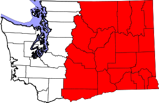
Eastern Washington is the region of the U.S. state of Washington located east of the Cascade Range. It contains the city of Spokane, the Tri-Cities, the Columbia River and the Grand Coulee Dam, the Hanford Nuclear Reservation and the fertile farmlands of the Yakima Valley and the Palouse. Unlike in Western Washington, the climate is dry, including some desert environments.

Lake Chelan is a narrow, 50.5-mile (81.3 km) long lake in Chelan County, north-central Washington state, U.S. Before 1927, it was the largest natural lake in the state by any measure. Upon the completion of Lake Chelan Dam in 1927, the elevation of the lake was increased by 21 feet (6.4 m) to its present maximum-capacity elevation of 1,100 feet (340 m). Two communities lie on the southern end of the lake, and a third sits at the far north end, providing a gateway to the North Cascades National Park.

Orondo is an unincorporated community in Douglas County, Washington, United States, located alongside the eastern part of the Columbia River. It is part of the Wenatchee–East Wenatchee Metropolitan Statistical Area. The area is well known for its robust agriculture industry, and produce fruits such as apples, cherries and pears. The name was derived from a mythical Great Lake Indian and was first settled in the late 19th century by late Washington politician, John B. Smith.

The Columbia Valley AVA is an American Viticultural Area which lies in the Columbia River Plateau, through much of central and southern Washington State, with a small section crossing into the neighboring state of Oregon. The AVA includes the drainage basin of the Columbia River and its tributaries through much of Washington. Allen Shoup, president of Washington State's largest winery Chateau Ste. Michelle, understood the importance of obtaining appellation status for Washington State to grow the reputation of the vineyards. He hired Drs. Wade Wolfe and Walter Clore to petition the federal government for appellation status, a request that was granted in 1984. The Columbia Valley AVA is the largest wine region in the state of Washington, including over 11,000,000 acres (4,500,000 ha), of which over 50,000 acres (20,000 ha) are planted in vineyards. The Columbia Valley AVA includes 99% of the total vineyard area planted in the state of Washington. Grapes grown here include Cabernet Sauvignon, Merlot, Chardonnay, Riesling, Syrah, Pinot Gris, and Sauvignon blanc. Concord grapes and other Vitis labrusca grapes are grown in the region as well. The unique climates of the area allow the Columbia Valley to produce wines that are very fruit-forward, like California wine, but which also retain some of the balance and structure of European wine.

Wenatchee Valley College (WVC) is a public community college in Wenatchee, Washington. The college provides students with adult education classes, certifications, associate degrees, and one bachelor's degree. WVC's primary service district is one of the largest in the state, serving an area larger than Massachusetts, at more than 10,000 square miles (30,000 km2).
Dryden is a small unincorporated community in Chelan County, Washington, United States. It is situated along the Wenatchee River in the fertile Wenatchee Valley between the towns of Cashmere and Leavenworth. The community serves as a supply and shipping point for local farms and orchards.

Winton, Washington is a small unincorporated community close to Lake Wenatchee and Wenatchee National Forest. It is in Chelan County in the state of Washington. The town's only school district, Cascade School District, is located in Leavenworth and includes five schools. It is assigned ZIP code 98826, the same as Leavenworth, Washington, approximately 10 miles (16 km) to the south.
Merritt-Leavenworth is an unincorporated community in Chelan County, Washington, United States. Merritt-Leavenworth is on US-2 in the upper valley area of Okanogan-Wenatchee National Forest, located, 20 miles West of downtown Leavenworth is assigned the ZIP code 98826.
Telma is an unincorporated community in Chelan County, Washington, United States. Telma is assigned the ZIP code 98826.
Wenatchee Heights is an unincorporated community in Chelan County, Washington, United States. Wentachee Heights is assigned the ZIP code 98801.


