
Lake Chelan is a narrow, 50.5 mi (81.3 km) long lake in Chelan County, north-central Washington state, U.S. It is an overdeepened lake and resembles a fjord, with an average width of 1.3 mi (2.1 km). Near its upper end, the lake surface lies more than 6,600 ft (2,000 m) below peaks less than 3 mi (4.8 km) away. Before 1927, Lake Chelan was the largest natural lake in the state in terms of both surface area and water volume. Upon the completion of Lake Chelan Dam in 1927, the elevation of the lake was increased by 21 ft (6.4 m) to its present maximum-capacity elevation of 1,100 ft (340 m).
Stehekin is a small unincorporated community in Chelan County, Washington. The name "Stehekin" comes from a word in the Salishan language that means "the way through". Stehekin has about 75 permanent residents, although its population swells during the summer with vacationers and seasonal workers.
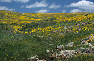
Wichita Mountains Wildlife Refuge, located in southwestern Oklahoma near Lawton, has protected unique wildlife habitats since 1901 and is the oldest managed wildlife facility in the United States Fish and Wildlife Service system. The refuge's location in the geologically unique Wichita Mountains and its areas of undisturbed mixed grass prairie make it an important conservation area. The Wichita Mountains are approximately 500 million years old. Measuring about 59,020 acres (238.8 km2), the refuge hosts a great diversity of species: 806 plant species, 240 species of birds, 36 fish, and 64 reptiles and amphibians are present.

The Stehekin River is a river located in Washington state in the Pacific Northwest of the United States. It is the main river flowing into Lake Chelan. Miners arrived in Stehekin River Valley in the late 19th century. They were followed by homesteaders in the early 20th century. Today, the Stehekin River Valley is still a remote area that can only be reached by way of a 55-mile boat ride up Lake Chelan.

Pontiac is a census-designated place in southern Ozark County, Missouri, United States. It lies six miles south of Isabella and 18.5 miles southwest of Gainesville, on the northeast shore of Bull Shoals Lake.
Holden Village is a year-round Lutheran Christian center in the North Cascade mountains of the U.S. state of Washington. Formerly the site of one of the largest copper mines in the United States, the Holden mine, Holden is accessible only by the Lake Chelan passenger ferry, the Lady of the Lake, or by hiking in through the Cascade Mountains. Holden Village is the largest retreat center in the nation operating under a special use permit from the United States Department of Agriculture - Forest Service.

The Enchantments is a region within the Alpine Lakes Wilderness area of Washington state's Cascade Mountain Range. At an elevation of 4,500 feet, it is home to over 700 alpine lakes and ponds surrounded by the vast peaks of Cashmere Crags, which rate among the best rock-climbing sites in the western United States. The highest peak, Dragontail Peak, stretches 8,840 feet high. The Enchantments is located 15 miles southwest of the popular Bavarian-themed town Leavenworth, Washington in the United States and is regarded as one of the most spectacular regions in the Cascade Range.

Lake Conasauga is a 19-acre (77,000 m2) lake in the Lake Conasauga Campground located near the summit of Grassy Mountain in the Chattahoochee National Forest in northern Georgia, United States. It is the highest lake in Georgia at 3,150 feet (960 m) above sea level. It was built by the Civilian Conservation Corps, which finished it in 1940. "Conasauga" is a name derived from the Cherokee language meaning "grass".

Garnet is an unincorporated community in Mackinac County in the U.S. state of Michigan. The community is located within Hudson Township. As an unincorporated community, Garnet has no legally defined boundaries or population statistics of its own.

The Purple Point-Stehekin Ranger Station House is a National Park Service ranger residence located in the Lake Chelan National Recreation Area of northern Washington. The building was built at Purple Point above Lake Chelan in the small, unincorporated community of Stehekin, Washington. It was originally constructed by the United States Forest Service to serve as the residence for the Stehekin District ranger. The Forest Service later converted it into a summer guard station. The building was transferred to the National Park Service in 1968 when the Lake Chelan National Recreation Area was established. The Purple Point-Stehekin Ranger Station House is listed on the National Register of Historic Places.

Peshastin is a small unincorporated community in Chelan County, Washington, United States. The community's roots are found in the "Peshastin Ditch" dug by pioneers beginning in 1889. This ditch was an important part of the overall irrigation system in the area, delivering water to the orchards on the slopes above Cashmere. The town was first platted in the early 1890s by two brothers, J. Q. Gilbert and A. C. Gilbert. It is also noted on an 1895 map of the area, indicating it was in existence by then.

Cardinal Peak is the highest peak of the Chelan Mountains, a subrange of the Cascade Range in the U.S. state of Washington. It is located in Wenatchee National Forest at the head of the Entiat River drainage basin, in Chelan County. To the west and north, streams flow into Lake Chelan. Cardinal Peak is less than 5 miles (8.0 km) from the lake and rises 7,500 feet (2,300 m) above the lakeshore. At 8,595 feet (2,620 m) high, it is the 49th highest peak in Washington. Its 2,070-foot (630 m) prominence ranks 132nd in the state.
Dryden is a small unincorporated community in Chelan County, Washington, United States. It is situated along the Wenatchee River in the fertile Wenatchee Valley between the towns of Cashmere and Leavenworth. The community serves as a supply and shipping point for local farms and orchards.

Monitor is a small unincorporated community in Chelan County, Washington, United States. It is situated along the Wenatchee River about 8 miles upstream from its junction with the Columbia River in the fertile Wenatchee Valley.
Ardenvoir is an unincorporated community in Chelan County, Washington, United States. Ardenvoir is 9 miles (14 km) west-northwest of Entiat. Ardenvoir has a post office with ZIP code 98811.
Merritt is an unincorporated community in Chelan County, Washington, United States. Merritt is on U.S. Route 2 in the upper valley area along Nason Creek in the Wenatchee National Forest, located 20 miles west of downtown Leavenworth. Merritt is assigned the ZIP code 98826. Steep slopes surround the community, rising to more than 8,000 feet in the Chiwaukum Mountains to the south.
Maplecreek is an unincorporated community in Chelan County, in the U.S. state of Washington. An alternate route of U.S. Route 97 runs through the community, connecting it with Chelan about 10 miles to the northeast and Entiat about 10 miles to the south.

Rainbow Falls is a waterfall on Rainbow Creek in the U.S. state of Washington. The waterfall is located inside the Lake Chelan National Recreation Area in the North Cascades National Park, and is near Stehekin. The falls drops 392 feet (119.5 m) in two tiers. The uppermost tier falls 312 feet (95.1 m) to a basin.

McGregor Mountain is an 8,122-foot (2,476-metre) elevation massif located in the Stehekin Valley of the North Cascades, in Chelan County of Washington state. McGregor Mountain is situated northwest of Lake Chelan in the northern Methow Mountains, on the shared border of North Cascades National Park and Lake Chelan National Recreation Area. The closest community is Stehekin, and the nearest higher neighbor is Goode Mountain, 7.3 miles (11.7 km) to the northwest. Precipitation runoff from the mountain drains into tributaries of the Stehekin River. Topographic relief is significant since the southern aspect of the mountain rises 6,600 feet above this river in approximately two miles. The famous Pacific Crest Trail traverses the western base of this mountain, and the strenuous 7.7-mile (12.4 km) McGregor Mountain Trail gains 6,400 feet of elevation to take hikers within a half-mile of the summit. Reaching the summit requires exposed scrambling the final 1,100 feet, and an ice axe is needed if the trail remains covered by snowpack. The summit was the site of an old fire lookout cabin from 1923 until 1955, but now has a radio repeater for the National Park Service. The views from the top include Glacier Peak, Black Peak, Corteo Peak, Frisco Mountain, Tupshin Peak, Dome Peak, Glory Mountain, and many others. This mountain was named for Billy McGregor, a Stehekin Valley resident who had a cabin and homestead at the base of this mountain during the 1890s. In May 1901, Billy disappeared overnight from a boat docked in Lake Chelan, and was never seen or heard from again.

Green Lake is a fresh water lake located in northwest Washtenaw County in the U.S. state of Michigan. The lake encompasses 90.5 acres (36.6 ha). It is located entirely within Lyndon Township about five miles (8.0 km) northwest of the city of Chelsea along M-52. The lake is located within Waterloo State Recreation Area along the northeastern edge of the park's boundaries near Pinckney State Recreation Area.


