Delmont, Pennsylvania

Last updated

Delmont, Pennsylvania
Borough
Delmont Pennsylvania 2012.jpg
Historic water trough on East Pittsburgh Street in Delmont
Westmoreland County Pennsylvania Incorporated and Unincorporated areas Delmont Highlighted.svg
Location of Delmont in Westmoreland County, Pennsylvania (left) and of Westmoreland County in Pennsylvania (right)
USA Pennsylvania location map.svg
Red pog.svg
Delmont, Pennsylvania
Coordinates: 40°24′47″N79°34′17″W / 40.41306°N 79.57139°W / 40.41306; -79.57139
Country United States
State Pennsylvania
County Westmoreland
Settled1814
Incorporated1833
Government
  TypeBorough Council
Area
[1]
  Total1.06 sq mi (2.73 km2)
  Land1.06 sq mi (2.73 km2)
  Water0.00 sq mi (0.00 km2)
Elevation
1,260 ft (380 m)
Population
 (2020) [2]
  Total2,596
  Density2,458.33/sq mi (949.19/km2)
Time zone UTC-5 (Eastern (EST))
  Summer (DST) UTC-4 (EDT)
Zip Code
15626
FIPS code 42-18768
Website Delmont's website

Delmont is a borough in Westmoreland County, Pennsylvania. The population was 2,592 at the 2020 census. [3]

Contents

History

Delmont was initially known as New Salem. The 300 acres of land was warranted to William Wilson in 1784, and upon his arrival in 1785, he named the area New Salem. In 1812, a post office was established in New Salem, "Salem X Roads" (Salem Crossroads), Pennsylvania. Hugh Bigham was the first postmaster. Wilson continued to farm on the land until he died in 1796.

After Wilson died in 1796, his estate was divided between his sons, Thomas and George. It was not until 1812 that the patent was validated. Eventually, the family conveyed their deeds to Thomas, who became the property's sole owner. Thomas divided the property into 48 lots to form a crossroads village. Thomas Wilson designed the town around a watering trough built in 1810 by Hugh Bigham. The watering trough was initially known as the running pump. The watering trough was connected with wooden pipes to a big Spring that's never known to run dry. In 1814, 48 lots were auctioned off two days before Christmas to form a crossroads town. As the area developed, the town was referred to locally as Salem Crossroads.

On April 8, 1833, the town was incorporated as "New Salem Borough." The mailing address was Salem Crossroads until 1871 when town postmaster Zachariah Zimmerman changed it to Delmont. The town and the post office carried two different names until May 16, 1967, when residents voted to change the borough's name to Delmont after a promotional campaign by then-Mayor Franklin Mangery. Major navigational roads were built through the area in the late 18th century, and local Route 66 was built in 1800. The East-West Northern Turnpike was completed in 1819, linking Philadelphia to Pittsburgh. Delmont was a busy stagecoach stop boasting at one time five stage coach lines through the village. Travelers would stop, tired and hungry, and patronize the several inns and taverns in town. In 1853, the Pennsylvania Railroad was completed through Westmoreland County to Pittsburgh. This was a faster, more economical way to travel. In 1855, the last stagecoach passed through the crossroads village, ending the stagecoach era for the crossroads town. [4]

Several areas and businesses in and around the borough still carry the Salem reference. Others refer to "Cloverleaf," which referred to the interchange at Routes 22 and 66, formerly a "cloverleaf" style exchange. It was changed to a single-point diamond interchange in 2000.

In the late 1970s, the Salem Crossroads Historical Restoration Society worked to maintain the local history and restore the area. As a result of its efforts, the National Register of Historic Places listed the Salem Crossroads Historic District in 1978. [5] In 1980, the society purchased Shields Farm. The farm hosts an annual Apple' N Arts festival during the first week of October; the festival held a 40th-anniversary event in 2022. [6]

The society disbanded at some point after its initial accomplishments. Downtown Delmont lost some businesses with the opening of chain retailers along the U.S. Route 22 corridor. Residents have discussed ways to reinvest in downtown Delmont and focus again on the town's historic resources. [7]

Salem Township and Delmont, a book about the area's history by writer Tracy Searight, was published in 2012. [8]

Geography

Allegheny-Wagner Industries on US Route 22 Allegheny-Wagner shredders Delmont from US 22 jeh.jpg
Allegheny-Wagner Industries on US Route 22

Delmont is located at 40°24′47″N79°34′17″W / 40.41306°N 79.57139°W / 40.41306; -79.57139 (40.412971, -79.571433). [9] According to the U.S. Census Bureau, the borough has a total area of 1.1 square miles (2.8 km2), all land. Delmont has been assigned the ZIP Code 15626.

Demographics

Historical population
CensusPop.Note
1850 299
1860 41940.1%
1870 4486.9%
1880 440−1.8%
1890 311−29.3%
1900 38122.5%
1910 42411.3%
1920 67158.3%
1930 7217.5%
1940 705−2.2%
1950 695−1.4%
1960 1,31388.9%
1970 1,93447.3%
1980 2,15911.6%
1990 2,041−5.5%
2000 2,49722.3%
2010 2,6867.6%
2020 2,592−3.5%
2021 (est.)2,569 [3] −0.9%
Sources: [10] [11] [12] [13] [2]

As of the census [11] of 2000, there were 2,497 people, 1,070 households, and 714 families residing in the borough. The population density was 2,333.1 inhabitants per square mile (900.8/km2). There were 1,139 housing units at an average density of 1,064.2 per square mile (410.9/km2). The racial makeup of the borough was 97.96% White, 0.52% African American, 0.04% Native American, 0.44% Asian, 0.04% from other races, and 1.00% from two or more races. Hispanic or Latino of any race were 0.24% of the population.

There were 1,070 households, of which 31.0% had children under 18 living with them, 55.4% were married couples living together, 9.3% had a female householder with no husband present, and 33.2% were non-families. 29.9% of all households were made up of individuals, and 12.1% had someone living alone who was 65 years of age or older. The average household size was 2.33, and the average family size was 2.91.

The borough's population was spread out, with 24.4% under 18, 6.2% from 18 to 24, 31.0% from 25 to 44, 24.7% from 45 to 64, and 13.7% who were 65 years of age or older. The median age was 39 years. For every 100 females, there were 92.2 males. For every 100 females aged 18 and over, there were 88.2 males.

The median income for a household in the borough was $39,700, and the median income for a family was $52,056. Males had a median income of $39,097 versus $25,804 for females. The per capita income for the borough was $21,090. About 4.6% of families and 6.9% of the population were below the poverty line, including 7.1% of those under age 18 and 14.9% of those aged 65 or over.

Education

Most primary and secondary education is provided by two school districts - Greensburg Salem, in Greensburg, and Franklin Regional, in Murrysville. Students to the south and east of the borough are generally assigned to Greensburg Salem, while the bulk of the students in the borough, and those who reside in the north and west portions, attend Franklin Regional.

The Franklin Regional district consists of three elementary schools (Sloan, Newlonsburg, Heritage), Franklin Regional Middle School, and Franklin Regional High School. The Greensburg-Salem District consists of three elementary schools (Metzgar, Nicely, Hutchinson), Greensburg-Salem Middle School, and Greensburg-Salem High School.

Roads

Aside from the historical genesis of the town as a toll intersection and stagecoach stop, one of Delmont's notable characteristics is that it is the meeting point of two major highways, U.S. Route 22 and State Route 66.

These roads were not directly intersected for many years but were linked by a cloverleaf interchange. Delmont became known for this interchange; many local merchants incorporated "Cloverleaf" into their business names. In 2000, the "cloverleaf" system was dismantled, and a single-point urban interchange was built in its place. This change was made to accommodate the widening of Route 22, one of Pennsylvania's most heavily traveled roads. The interchange on Route 22 marks the boundary between suburban Pittsburgh and the more rural foothills of the Appalachian Mountains.

Other notable roads within Delmont's borders include Old William Penn Highway, which begins at the termination of Pittsburgh Street, just west of Route 66, and Manor Road, which begins on the west side of Route 66 as well, just across from Greensburg Street, and runs from 66 through the southeastern portion of the 22/66 corridor until it reaches Route 22 outside of city limits, as 22 goes toward Export and Murrysville.

Historical sites

Recreation sites

Related Research Articles

<span class="mw-page-title-main">Westmoreland County, Pennsylvania</span> County in Pennsylvania, United States

Westmoreland County is a county in the Commonwealth of Pennsylvania, United States, located in the Pittsburgh Metropolitan Statistical Area. As of the 2020 census, the population was 354,663. The county seat is Greensburg and the most populous community is Hempfield Township. It is named after Westmorland, a historic county of England.

<span class="mw-page-title-main">Salem, Connecticut</span> Town in Connecticut, United States

Salem is a town in New London County, Connecticut, United States. The town is part of the Southeastern Connecticut Planning Region. The population was 4,213 at the 2020 census.

<span class="mw-page-title-main">Brentwood, Pennsylvania</span> Borough in Pennsylvania, United States

Brentwood is a borough in Allegheny County, Pennsylvania, United States. The population was 10,082 at the 2020 census. It is a residential suburb of the Pittsburgh metropolitan area.

<span class="mw-page-title-main">Monroeville, Pennsylvania</span> Borough in Pennsylvania, United States

Monroeville is a home rule municipality in Allegheny County, Pennsylvania, United States. It is a suburb with mixed residential and commercial developments located about 10 miles (16 km) east of Pittsburgh. As of the 2020 census, Monroeville was home to 28,640 people.

<span class="mw-page-title-main">Manns Choice, Pennsylvania</span> Borough in Pennsylvania, United States

Manns Choice is a borough in Bedford County, Pennsylvania, United States. The population was 316 at the 2020 census.

<span class="mw-page-title-main">Connellsville, Pennsylvania</span> City in Pennsylvania, United States

Connellsville is a city in Fayette County, Pennsylvania, United States, 36 miles (58 km) southeast of Pittsburgh and 50 miles (80 km) away via the Youghiogheny River, a tributary of the Monongahela River. It is part of the Pittsburgh metropolitan area. The population was 7,031 at the 2020 census.

<span class="mw-page-title-main">Export, Pennsylvania</span> Borough in Pennsylvania, United States

Export is a borough in Westmoreland County, Pennsylvania, United States, surrounded entirely by the municipality of Murrysville. The population was 893 at the 2020 census.

<span class="mw-page-title-main">Greensburg, Pennsylvania</span> City in Pennsylvania, United States

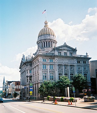
Greensburg is a city in and the county seat of Westmoreland County, Pennsylvania, United States. The population was 14,976 at the 2020 census. Located 30 miles (48 km) southeast of Pittsburgh, Greensburg is a part of the Pittsburgh metropolitan area. The city lies within the Laurel Highlands and the ecoregion of the Western Allegheny Plateau. The city is named after Nathanael Greene, a major general of the Continental Army in the American Revolutionary War.

<span class="mw-page-title-main">Hempfield Township, Westmoreland County, Pennsylvania</span> Township in Pennsylvania, United States

Hempfield Township is a township in Westmoreland County, Pennsylvania, United States. The population was 41,585 at the 2020 census, making it the largest suburb in the Pittsburgh Metropolitan Area by population. Its name is derived from Hempfield in Lancaster County, which was formed in 1729 and is named after the hemp fields in the area.

<span class="mw-page-title-main">Murrysville, Pennsylvania</span> Home rule municipality in Pennsylvania, United States

Murrysville is a home rule municipality in Westmoreland County, Pennsylvania, United States. The population was 21,006 at the 2020 census. It is part of the Pittsburgh metropolitan area.

<span class="mw-page-title-main">Penn Township, Westmoreland County, Pennsylvania</span> Township in Pennsylvania, United States

Penn Township is a township in Westmoreland County, Pennsylvania, United States.

<span class="mw-page-title-main">Slickville, Pennsylvania</span> CDP in Pennsylvania, United States

Slickville is a census-designated place (CDP) in Westmoreland County, Pennsylvania, United States. The population was 372 at the 2000 census.

<span class="mw-page-title-main">South Greensburg, Pennsylvania</span> Borough in Pennsylvania, United States

South Greensburg is a borough in Westmoreland County, Pennsylvania, United States. The population was 2,117 at the 2010 census.

<span class="mw-page-title-main">Franklin Regional School District</span> School district in Pennsylvania

Franklin Regional School District is a midsized, suburban public school district located in Murrysville, Pennsylvania, serving Murrysville and the neighboring communities of Delmont and Export. Franklin Regional School District encompasses approximately 38 square miles (98 km2). According to 2020 federal census data, it serves a resident population of 19,438 people. According to District officials, in school year 2021-22, Franklin Regional School District provided basic educational services to 3,555 pupils through the employment of 249 teachers, 152 full-time and part-time support personnel, and 19 administrators.

<span class="mw-page-title-main">Darlington, Maryland</span> Historic district in Maryland, United States

Darlington is an unincorporated community and census-designated place in northeastern Harford County, Maryland, United States. The population was 409 at the 2010 census. The center of the community was listed on the National Register of Historic Places as the Darlington Historic District in 1987. Median household income is $66,563. The percentage of people in poverty is 5.3%.

<span class="mw-page-title-main">U.S. Route 30 in Pennsylvania</span> Highway in Pennsylvania

U.S. Route 30 (US 30) is a U.S. Highway that runs east–west across the southern part of Pennsylvania, passing through Pittsburgh and Philadelphia on its way from the West Virginia state line east to the Benjamin Franklin Bridge over the Delaware River into New Jersey.

<span class="mw-page-title-main">U.S. Route 22 in Pennsylvania</span> Highway in Pennsylvania

U.S. Route 22 (US 22) is an east–west United States Numbered Highway that stretches from Cincinnati, Ohio, in the west, to Newark, New Jersey, in the east. In Pennsylvania, the route runs for 338.20 miles (544.28 km) between the West Virginia state line in Washington County, where it is a freeway through the western suburbs of Pittsburgh, and then runs east to Easton and the Pennsylvania–New Jersey state line in the Lehigh Valley region of eastern Pennsylvania.

<span class="mw-page-title-main">Pennsylvania Route 66</span> State highway in Pennsylvania, US

Pennsylvania Route 66 (PA 66) is a 139.7-mile-long (224.8 km) state highway in Western Pennsylvania. Its southern terminus is at U.S. Route 119 just east of Interstate 70 (I-70) near New Stanton. Its northern terminus is at US 6 in Kane.

<span class="mw-page-title-main">Pennsylvania Route 366</span> State highway in Pennsylvania, US

Pennsylvania Route 366 is a 14.8-mile-long (23.8 km) state highway located in Allegheny and Westmoreland counties in Pennsylvania. The western terminus is at PA 28 in Tarentum. The eastern terminus is at PA 66 in Murrysville. The last 1/2 mile of the Red Belt route of the Allegheny County belt system runs along PA 366 in Tarentum from its eastbound beginning at the PA 28 interchange to the intersection of Freeport Rd. and Ross St. where the Red Belt terminates.

<span class="mw-page-title-main">Westmoreland Heritage Trail</span> Rail trail in Pennsylvania, U.S.

The Westmoreland Heritage Trail is a partially completed rail trail in southwestern Pennsylvania. As of 2019, 18.0 miles of the 21.9 planned miles of trail are complete, including an 8.7 mile section from Saltsburg to the fringe of Delmont as well as a 9.3 mile section from Trafford to Export.

References

  1. 42'&outFields=NAME,STATE,PLACE,AREALAND,AREAWATER,LSADC,CENTLAT,CENTLON&orderByFields=PLACE&returnGeometry=false&returnTrueCurves=false&f=json "ArcGIS REST Services Directory". United States Census Bureau. Retrieved October 12, 2022.{{cite web}}: Check |url= value (help)
  2. 1 2 "Census Population API". United States Census Bureau. Retrieved October 12, 2022.
  3. 1 2 Bureau, US Census. "City and Town Population Totals: 2020—2021". Census.gov. US Census Bureau. Retrieved July 26, 2022.
  4. "Book's pages flip through rich history of Delmont, Salem Township". Trib Total Media. October 22, 2012. Retrieved January 12, 2014.
  5. "National Register Information System". National Register of Historic Places . National Park Service. July 9, 2010.
  6. "Delmont group presses on through rain, welcomes many visitors to Apple' n Arts fest". October 2022.
  7. "Delmont residents seek to establish historical society". January 15, 2020.
  8. "Welcome".
  9. "US Gazetteer files: 2010, 2000, and 1990". United States Census Bureau. February 12, 2011. Retrieved April 23, 2011.
  10. "Census of Population and Housing". U.S. Census Bureau. Retrieved December 11, 2013.
  11. 1 2 "U.S. Census website". United States Census Bureau . Retrieved January 31, 2008.
  12. "Incorporated Places and Minor Civil Divisions Datasets: Subcounty Resident Population Estimates: April 1, 2010 to July 1, 2012". Population Estimates. U.S. Census Bureau. Archived from the original on June 11, 2013. Retrieved December 11, 2013.
  13. "Census of Population and Housing". Census.gov. Retrieved June 4, 2016.
  14. 1 2 "Salem Crossroads Historic District, Delmont Borough, Westmoreland County, Delmont PA 15626". livingplaces.com.
  15. "Delmont residents seek to establish historical society". January 15, 2020.
  16. "History". September 8, 2008. Archived from the original on September 8, 2008.
  17. "ccpa". TribLIVE.com. Archived from the original on January 31, 2013. Retrieved July 2, 2021.
  18. "Apple Hill Playhouse property sold to Washington County developer". July 15, 2021.
  19. "Delmont's new library set for grand opening". January 18, 2021.
  20. "Center Ice Arena". Archived from the original on June 17, 2008. Retrieved March 5, 2009.
  21. "Kovalczik Park".
  22. "2005 Monster Energy/Kawasaki Nationals at Steel City Raceway". Archived from the original on May 27, 2006. Retrieved March 5, 2009.

Sources