Grafton, New York

Last updated

Grafton, New York
Saint John Francis Regis Catholic Church (Grafton, New York) - sign.jpg
St. John Francis Regis Catholic Church in Grafton
Motto: 
Beauty is All Around Us
Rensselaer County New York incorporated and unincorporated areas Grafton highlighted.svg
Location in Rensselaer County and the state of New York.
Coordinates: 42°46′14″N73°27′15″W / 42.77056°N 73.45417°W / 42.77056; -73.45417
Country United States
State New York
County Rensselaer
Area
[1]
  Total45.96 sq mi (119.04 km2)
  Land44.72 sq mi (115.83 km2)
  Water1.24 sq mi (3.21 km2)
Elevation
1,440 ft (439 m)
Population
 (2020)
  Total2,051
  Density45/sq mi (17/km2)
Time zone UTC-5 (Eastern (EST))
  Summer (DST) UTC-4 (EDT)
ZIP code
12082
Area code 518
FIPS code 36-29674
GNIS feature ID0979010

Grafton is a town in Rensselaer County, New York, United States. The population was 2,051 at the 2020 census. [2] It is believed that the town received its name from Grafton, Vermont, [3] where the first town supervisor, Nathaniel Dumbleton, was originally from. The town is an interior town near the north-central part of the county. NY Route 2 passes across the town.

Contents

Grafton is notable for having a Peace Pagoda, built by Nipponzan Myohoji buddhist order in 1993.

History

The town of Grafton was originally a part of the Manor of Rensselaerswyck, and at that time was known as Roxborough. [4] The first settlements are not clear from the ca. 1765-1807 map of the manor. [5] As part of Rennesselaerswyck, the first inhabitants were renters of that estate.

The question of the first settlement of Grafton has never been settled. The names of the first European settlers who built new homes in the wilderness and the date of their coming probably will never be known. In all probability, however, the town was the last in Rensselaer County to be settled. Grafton was formed from the towns of Troy and Petersburgh on March 20, 1807, and even at this comparatively late day it had few inhabitants. Abel Owen is generally believed to have been the first man to enter the rather unattractive mountain wilderness and build himself a home. He was sturdy farmer, an indefatigable laborer, and to encourage further settlement the patroon, Stephen Van Rensselaer III, gave him a grant of 200 acres (81 ha) or more of what was then thought to be the best land in that section adapted to farming. Owen was not long without neighbors, if indeed there were not one or more families located in that vicinity when he built his log house. [6]

There is nothing to show when Mr. Owen moved to Grafton, but from subsequent settlements and other occurrences it is thought that it could not have been very long after the Revolutionary War. Possibly it was several years later, during that war or at its close. Immediately after the period when the colonists were fighting for independence, or beginning with 1784 or 1785, several families leased land in Grafton from the patroon and began the cultivation of the land there. Abel Owen is recorded as a Revolutionary soldier, so the town likely was not settled until the closing years of the war or later. Circa 1786, Owen had at least two neighbors, families names Coon and Demmon being early lessees of the patroon's lands. About 1796 Abel Owen sold his farm to Lemuel Steward and moved with his family to Onondaga County. [7]

Nathaniel Dumbleton, who was first elected to the office of supervisor, moved to the town from Grafton, Vermont, and tradition says that through his influence the town received the name which it has since borne. The first town meeting was held soon after the organization, on the first Tuesday of April 1807 at the house of Nathan Hakes. [8]

Two taverns are mentioned by various authorities as the earliest in town. one was located at East Grafton and was built and maintained by Thomas Scriven; the other was located in the western part of the town and was kept by Elijah Terry. The tavern of S. McChesney was opened about the year 1800. The Grafton House was built about 1838 by Stephen Van Rensselaer. It was the most pretentious affair in the town and for many years one of the most prominent taverns in the central part of the county. [8]

About the year 1800 Josiah Litchfield opened a general store at Quackenkill, erecting a saw mill about the same time. S. McChesney, in addition to his tavern, also kept an early store at Quackenkill. Van Rensselaer built a grist mill in 1836 or 1837. These were for many years the principal business enterprises in Grafton. [8]

The first physician to practice in town of whom there is any knowledge was Dr. Rufus S. Waite, a native of Petersburgh, who came to Grafton Center from Brownsville in 1819. He practiced for about forty years and became widely known throughout Rensselaer County. Dr. Amos Allen, also a native of Petersburgh, settled in Grafton in 1846, immediately after his graduation from the Berkshire Medical School. For many years Dr. Allen was the only physician in the town. [8]

When, in pursuance of the school law of 1812–1813, the town voted its first appropriation for the maintenance of the schools at public expense, Jedediah Wellman, Daniel Mills and Thomas West were chosen school commissioners. In the fall of 1813 the town was divided into ten districts, and soon after a common school was maintained in each district. In common with all other towns in the state, the school system was changed from time to time in accordance with legislative enactment. under the system of supervision by town superintendents, Thomas W. potter served in 1844 and 1845, John C. Potter in 1846, Paul K. Davison in 1847 and 1848, Dr. Amos Allen from 1850 to 1853 and Daniel H. Davison from 1854 to 1856. [9]

December 19, 1845, saw a tragedy in Grafton, one of the many taking place in Rensselaer County during the Anti-Rent War, following the death of Stephen Van Rensselaer III. Elijah Smith was shot by an unknown person during one of the numerous struggles which took place between the anti renters and the authorities of the county. [10]

Some of the earlier industries in Grafton are referred to above. Saw mills were among the earliest enterprises, as they were rendered necessary by the presence of an almost unbroken forest over mountain and valley. These mills also sent out large quantities of tan bark, and vast quantities of the wood were reduced to charcoal and sent to nearby markets. As the timber was cleared away the inhabitants began to pay more attention to agriculture, stock raising, and dairying. The manufacture of shirts was begun about 1855 by Caleb W. Scriven, who introduced the first sewing machine in the town. The work was done by his employees at their homes and the product of their toil was sent to New York City. Others who engaged in the business at the early day were the firm of J.H. & A.H. Scriven, Ford & Bennett and their successors. Many families in town found the industry as a profitable one at the time. [10]

The Dickinson Hill Fire Tower was listed on the National Register of Historic Places in 2011. [11]

Geography

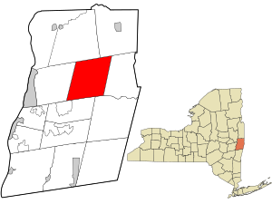
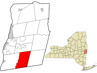
The town of Grafton is located north of the center of Rensselaer County. It is bounded on the north by Pittstown and Hoosick, on the east by Petersburgh, on the south by Berlin and Poestenkill and on the west by Brunswick. Like Stephentown, it is rectangular in shape. Its surface contains more small lakes and ponds than any other town in the county, and these are the headwaters of many streams flowing in every direction. The town may be said to be the center of the watershed of Rensselaer County. [12]

Grafton possesses the most uneven surface of any town in the county. It is located within the limits of the Rensselaer Plateau [13] and the principal peaks in the town reach an altitude of 1800 feet above the level of the sea. A small portion of the land only is arable, but the hillsides afford excellent grazing. Nevertheless, many of the inhabitants of Grafton have farms which, by years of constant care and cultivation, have been rendered almost as productive as any within the county. [14]

As already stated, ponds and small streams are very abundant. Cranberry Lake, or Cranberry Pond, in the southern part, is the source of the Quacken Kill, which flows by a devious course to the western limits of the town, affording numerous excellent mill sites. In the northern part of the town are several creeks flowing towards the Hoosick Valley. The ponds of Grafton are noted for the purity and high quality of their water, and some of them on this account were once considered as available sources of supply for Troy's drinking water.

According to the United States Census Bureau, the town has a total area of 46.0 square miles (119 km2), of which 44.9 square miles (116 km2) is land and 1.1 square miles (2.8 km2) (2.35%) is water.

The town is mostly a highland, continuing the Taconics north, or the Berkshires west. The scenic beauty of the area is seen at the Grafton Lakes State Park, a park with four lakes among gentle mountain scenery.

Adjacent towns and areas

The town is south of the Towns of Hoosick and Pittstown.

Demographics

Historical population
CensusPop.Note
1820 1,611
1830 1,6814.3%
1840 2,01920.1%
1850 2,0330.7%
1860 1,837−9.6%
1870 1,599−13.0%
1880 1,6764.8%
1890 1,457−13.1%
1900 1,136−22.0%
1910 1,019−10.3%
1920 733−28.1%
1930 633−13.6%
1940 83632.1%
1950 96415.3%
1960 1,0094.7%
1970 1,30729.5%
1980 1,66527.4%
1990 1,91715.1%
2000 1,9873.7%
2010 2,1307.2%
2020 2,051−3.7%
U.S. Decennial Census [15] [16]

As of the census [17] of 2000, there were 1,987 people, 747 households, and 554 families residing in the town. The population density was 44.3 inhabitants per square mile (17.1/km2). There were 1,059 housing units at an average density of 23.6 units per square mile (9.1 units/km2). The racial makeup of the town was 97.99% White, 0.15% African American, 0.35% Native American, 0.20% Asian, 0.25% from other races, and 1.06% from two or more races. Hispanic or Latino of any race were 0.45% of the population.

There were 747 households, out of which 33.5% had children under the age of 18 living with them, 62.4% were married couples living together, 7.8% had a female householder with no husband present, and 25.8% were non-families. 21.0% of all households were made up of individuals, and 6.8% had someone living alone who was 65 years of age or older. The average household size was 2.66 and the average family size was 3.10.

In the town, the population was spread out, with 25.2% under the age of 18, 8.2% from 18 to 24, 28.7% from 25 to 44, 28.4% from 45 to 64, and 9.5% who were 65 years of age or older. The median age was 38 years. For every 100 females, there were 100.7 males. For every 100 females age 18 and over, there were 100.9 males.

The median income for a household in the town was $48,347, and the median income for a family was $53,810. Males had a median income of $38,333 versus $28,750 for females. The per capita income for the town was $21,312. About 4.4% of families and 6.0% of the population were below the poverty line, including 6.7% of those under age 18 and 5.9% of those age 65 or over.

Communities and locations in Grafton

Education

The westernmost part of the town is serviced by Brunswick (Brittonkill) Central School District and the remainder by the Berlin Central School District.

Notable people

Related Research Articles

<span class="mw-page-title-main">Rensselaer County, New York</span> County in New York, United States

Rensselaer County is a county in the U.S. state of New York. As of the 2020 census, the population was 161,130. Its county seat is Troy. The county is named in honor of the family of Kiliaen van Rensselaer, the original Dutch owner of the land in the area. The county is part of the Capital District region of the state.

<span class="mw-page-title-main">Berlin, New York</span> Town in New York, United States

Berlin is a town in Rensselaer County, New York, United States. The population was 1,808 at the 2020 census. The town is named after Berlin in Germany, although natives pronounce the name differently, with the accent on the first syllable.

<span class="mw-page-title-main">Brunswick, New York</span> Town in New York, United States

Brunswick is a town in Rensselaer County, New York, United States. The municipality was originally settled in the early 18th century. During its history, it had been part of Albany County, Rensselaerswyck, and Troy, before its incorporation in 1807. It is bordered on the west by the city of Troy; on the north by Schaghticoke and Pittstown; on the east by Grafton; and on the south by Poestenkill and North Greenbush. The population was 12,581 at the 2020 census. The source of the town's name is not certain, though some claim it comes from the source of its first inhabitants from the province of Brunswick-Lüneburg in Germany.

<span class="mw-page-title-main">Hoosick, New York</span> Town in New York, United States

Hoosick is a town in Rensselaer County, New York, United States. The population was 6,711 at the 2020 census. It was named from the Hoosic River.

<span class="mw-page-title-main">North Greenbush, New York</span> Town in New York, United States

North Greenbush is a town in Rensselaer County, New York, United States. North Greenbush is located in the western part of the county. The population was 13,292 at the 2020 census.

<span class="mw-page-title-main">Petersburgh, New York</span> Town in New York, United States

Petersburgh is a town located in the northeast section of Rensselaer County, New York, United States. The population was 1,372 at the 2020 census. The town was named after an early settler named Peter Simmons.

<span class="mw-page-title-main">Pittstown, New York</span> Town in New York, United States

Pittstown is a town in Rensselaer County, New York, United States. The population was 5,540 at the 2020 census. It is in the northern part of the county.

<span class="mw-page-title-main">Sand Lake, New York</span> Town in New York, United States

Sand Lake is a town in south-central part of Rensselaer County, New York, United States. Sand Lake is about 13 miles east of Albany, New York. As of the 2020 census, the population was 8,348. Within the town are three hamlets: Averill Park, Glass Lake and the hamlet of Sand Lake. Its four lakes are a source of recreation. Many commercial enterprises of the 19th century and into the 20th century relied on power generated from the Wynants Kill Creek and Burden Lake mills. The area is known for its fertile soil for grazing and agriculture.

<span class="mw-page-title-main">Chatham, New York</span> Town in New York, United States

Chatham is a town in Columbia County, New York, United States. The population was 4,104 at the 2020 census, down from the 2010 census.

<span class="mw-page-title-main">East Greenbush, New York</span> Town in New York, United States

East Greenbush is a town in Rensselaer County, New York, United States. It is a suburb of Albany. The population was 16,748 at the 2020 census. The word Greenbush is derived from the Dutch het groen bosch, referring to the pine woods that originally covered the land. The first settlement of the land now known as East Greenbush was made by tenants under patroon Kiliaen van Rensselaer circa 1630. The town was established in 1855 as Clinton, and was renamed in 1858. It is mostly suburban along its major highways and rural in the southwestern and northeastern corners.

<span class="mw-page-title-main">Nassau, New York</span> Town in Rensselaer County, New York, US

Nassau is a town in Rensselaer County, New York, United States. The population was 4,545 in 2020, down from 4,789 at the 2010 census.

<span class="mw-page-title-main">Poestenkill, New York</span> Town in Rensselaer County, New York

Poestenkill is a town in Rensselaer County, New York, United States. The population was 4,322 at the 2020 census. The town is southeast of Troy and is centrally located in the county.

<span class="mw-page-title-main">Hoosic River</span> River in New York, United States

The Hoosic River, also known as the Hoosac, the Hoosick and the Hoosuck, is a 76.3-mile-long (122.8 km) tributary of the Hudson River in the northeastern United States. The different spellings are the result of varying transliterations of the river's original Algonquian name. It can be translated either as "the beyond place" or as "the stony place".

<span class="mw-page-title-main">New York State Route 2</span> State highway in Albany and Rensselaer counties in New York, US

New York State Route 2 (NY 2) is a state highway in the Capital District of New York in the United States. It extends for 30.89 miles (49.71 km) from an interchange with Interstate 87 (I-87) and NY 7 in the town of Colonie to the Massachusetts state line in Petersburgh, where it continues to Boston as Massachusetts Route 2. The route passes through the cities of Watervliet and Troy, where it connects to NY 32 and U.S. Route 4, respectively. In Grafton, located midway between Troy and Massachusetts, NY 2 serves Grafton Lakes State Park.

<span class="mw-page-title-main">Grafton Lakes State Park</span> State park in Rensselaer County, New York

Grafton Lakes State Park is a 2,545-acre (10.30 km2) state park located in Rensselaer County, New York, United States. The park is in the central part of the Town of Grafton and north of the hamlet of Grafton on NY Route 2, northeast of Albany. The park contains the Shaver Pond Nature Center.

<span class="mw-page-title-main">State Route 346 (New York–Vermont)</span> State highway in New York and Vermont, US

New York State Route 346 (NY 346) and Vermont Route 346 (VT 346) are short, adjoining state highways in the northeastern United States. Together, they extend for a combined 7.25 miles (11.67 km) through the towns of Petersburgh in Rensselaer County, New York, and Pownal in Bennington County, Vermont. The bi-state highway begins at an intersection with NY 22 in the hamlet of North Petersburgh and heads generally southeastward across the New York–Vermont state line to a junction with U.S. Route 7 (US 7) in the village of Pownal. Both NY 346 and VT 346 parallel the Hoosick River.

<span class="mw-page-title-main">Taconic Crest Trail</span>

The Taconic Crest Trail is a 37 mi (60 km) hiking trail in the Taconic Mountains in the northeastern United States. The trail extends from U.S. Route 20 in Hancock, Massachusetts, less than 1 mi (1.6 km) east of the New York border, north along the ridgecrest of the Taconic Range, first within Massachusetts, then weaving along the border of New York and Massachusetts and New York and Vermont, and ending in Petersburgh, New York, on NY Route 346, near the Vermont border. Much of the route has been conserved as state forest, conservation easement, or forest preserve.

<span class="mw-page-title-main">Poesten Kill</span> River in New York, United States

The Poesten Kill is a 26.2-mile-long (42.2 km) creek in Rensselaer County, Upstate New York. It flows westerly from its source at Dyken Pond in the town of Berlin to its mouth at the Hudson River in the city of Troy. The creek was used historically as a source of water for the local inhabitants and farmers. During the Industrial Revolution, it became an important source of water power, and many mills and factories sprung up along its banks.

<span class="mw-page-title-main">History of Troy, New York</span>

The history of Troy, New York extends back to the Mohican Indians. Troy is a city on the east bank of the Hudson River about 5 miles (8.0 km) north of Albany in the US State of New York.

References

  1. "2016 U.S. Gazetteer Files". United States Census Bureau. Retrieved July 5, 2017.
  2. U.S. Census Bureau, 2020 census results, Grafton, New York. https://www.census.gov/search-results.html?searchType=web&cssp=SERP&q=Grafton%20town,%20Rensselaer%20County,%20New%20York
  3. University of the State of New York Bulletin. University of the State of New York. 1914. p. 52.
  4. "Van Rensselaer (Rensselaerwyck) Manor Records, 1630-1899, SC7079, A Preliminary Inventory". New York State Library. Retrieved March 12, 2016.
  5. http://nysl.nysed.gov/Archimages/106605.PDF%5B%5D
  6. Anderson (1897), pp. 562–563
  7. Anderson (1897), p. 563
  8. 1 2 3 4 Anderson (1897), p. 564
  9. Anderson (1897), pp. 564–565
  10. 1 2 Anderson (1897), p. 565
  11. "National Register of Historic Places Listings". Weekly List of Actions Taken on Properties: 5/09/11 through 5/13/11. National Park Service. May 20, 2011.[ permanent dead link ]
  12. Anderson (1897), pp. 561–562
  13. "Rensselaer Plateau Association - Maps". Archived from the original on December 24, 2013. Retrieved August 26, 2013.
  14. Anderson (1897), p. 562
  15. "Census of Population and Housing". Census.gov. Retrieved June 4, 2015.
  16. U.S. Census Bureau, 2020 census results, Grafton, New York. https://www.census.gov/search-results.html?searchType=web&cssp=SERP&q=Grafton%20town,%20Rensselaer%20County,%20New%20York
  17. "U.S. Census website". United States Census Bureau . Retrieved January 31, 2008.
  18. Michigan Supreme Court Historical Society-Sanford Green

Bibliography

Further reading

PD-icon.svg This article incorporates text from Landmarks of Rensselaer County New York, by George Baker Anderson (1897), a publication now in the public domain.

42°46′08″N73°27′03″W / 42.76889°N 73.45083°W / 42.76889; -73.45083