Valley Falls, New York

Last updated

Valley Falls, New York
Rensselaer County New York incorporated and unincorporated areas Valley Falls highlighted.svg
Location in Rensselaer County and the state of New York.
USA New York location map.svg
Red pog.svg
Valley Falls, New York
Location within the state of New York
Coordinates: 42°54′3″N73°33′45″W / 42.90083°N 73.56250°W / 42.90083; -73.56250
Country United States
State New York
County Rensselaer
Valley Falls1904
Area
[1]
  Total0.49 sq mi (1.27 km2)
  Land0.46 sq mi (1.20 km2)
  Water0.03 sq mi (0.06 km2)
Elevation
335 ft (102 m)
Population
 (2020)
  Total510
  Density1,101.51/sq mi (424.89/km2)
Time zone UTC-5 (Eastern (EST))
  Summer (DST) UTC-4 (EDT)
ZIP code
12185
Area code 518
FIPS code 36-76672
GNIS feature ID0968358

Valley Falls is a village in Rensselaer County, New York, United States. The population was 466 at the 2010 census. The village lies on the boundary of the towns of Pittstown and Schaghticoke, but is mostly in the northwestern part of Pittstown.

Contents

History

Valley Falls free library. Valley Falls Library.jpg
Valley Falls free library.

In 1871, industrialist James Thompson built a textile mill in the village. [2] Nearly all village residents worked in the mill and schoolchildren ran home when the mill's lunch whistle sounded. After its height of operation in the 1970s, it entered a decade of decline. The mill had been vacant for at least 10 years when it went up in flames in the early morning hours on April 22, 2009. [3]

Community Hall in Valley Falls. Valley Falls NY Community Hall.jpg
Community Hall in Valley Falls.

By 1863, Valley Falls had established itself as a mini-industrial center. In addition to the aforementioned Thompson textile mill, the village also had a blacksmith shop, farrier shop, foundry, wainwright shop, cooperage, vineyard, three general stores, and two hotels. At this time only a single rail line (Troy & Boston RR) from Troy passed through the southern limit of the village, heading to Johnsonville. Later, a second rail line from Schaghticoke would follow the Hoosic River past Thompson's Mill, also heading to Johnsonville. [4] By the early 1970s, the southern rail line was completely abandoned and had been largely dismantled; the northern line still functions to this day. However, with the closing of the Thompson mill, the train no longer stops in Valley Falls.

Perspective map of Valley Falls from 1887 by L.R. Burleigh including a list of landmarks Valley Falls, N.Y. 1887. LOC 75694858.jpg
Perspective map of Valley Falls from 1887 by L.R. Burleigh including a list of landmarks

Valley Falls in the hometown of Allan C. Balch, public utilities executive and namesake for Cornell's Balch Hall.

The Adams–Myers–Bryan Farmstead was listed on the National Register of Historic Places in 2013. [5]

Geography

Valley Falls is located at 42°54′3″N73°33′45″W / 42.90083°N 73.56250°W / 42.90083; -73.56250 (42.900846, -73.562495). [6]

The Hoosic River unequally divides the village. The majority of the village is on the southern side of the Hoosic in the township of Pittstown and the "Village Annex" on the northern side is in the township of Schaghticoke.

According to the United States Census Bureau, the village has a total area of 0.5 square miles (1.3 km2), of which 0.4 square miles (1.0 km2) is land and 0.04 square miles (0.10 km2) (4.35%) is water.

Demographics

Historical population
CensusPop.Note
1870 600
1880 78230.3%
1910 835
1920 633−24.2%
1930 577−8.8%
1940 564−2.3%
1950 555−1.6%
1960 5896.1%
1970 68115.6%
1980 554−18.6%
1990 527−4.9%
2000 491−6.8%
2010 466−5.1%
2020 5109.4%
U.S. Decennial Census [7]

As of the census [8] of 2000, there were 491 people, 179 households, and 132 families residing in the village. The population density was 1,119.6 inhabitants per square mile (432.3/km2). There were 191 housing units at an average density of 435.5 per square mile (168.1/km2). The racial makeup of the village was 97.35% White, 1.43% Native American, 0.81% Asian, and 0.41% from two or more races. Hispanic or Latino of any race were 0.61% of the population.

There were 179 households, out of which 42.5% had children under the age of 18 living with them, 55.9% were married couples living together, 15.6% had a female householder with no husband present, and 25.7% were non-families. 19.6% of all households were made up of individuals, and 9.5% had someone living alone who was 65 years of age or older. The average household size was 2.74 and the average family size was 3.20.

In the village, the population was spread out, with 30.8% under the age of 18, 5.7% from 18 to 24, 32.8% from 25 to 44, 20.0% from 45 to 64, and 10.8% who were 65 years of age or older. The median age was 35 years. For every 100 females, there were 91.1 males. For every 100 females age 18 and over, there were 92.1 males.

The median income for a household in the village was $56,250, and the median income for a family was $59,583. Males had a median income of $34,808 versus $28,750 for females. The per capita income for the village was $20,989. About 7.2% of families and 4.4% of the population were below the poverty line, including 7.4% of those under age 18 and none of those age 65 or over.

Related Research Articles

<span class="mw-page-title-main">Rensselaer County, New York</span> County in New York, United States

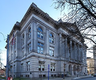
Rensselaer County is a county in the U.S. state of New York. As of the 2020 census, the population was 161,130. Its county seat is Troy. The county is named in honor of the family of Kiliaen van Rensselaer, the original Dutch owner of the land in the area. The county is part of the Capital District region of the state.

<span class="mw-page-title-main">Honeoye Falls, New York</span> Village in New York, United States

Honeoye Falls is a village within the town of Mendon in Monroe County, New York, United States. The population was 2,706 at the 2020 census. The village includes a small waterfall on Honeoye Creek, which flows through the village and gives it its name. The name Honeoye comes from the Seneca word ha-ne-a-yah, which means lying finger, or where the finger lies. The name comes from the local story of a Native American whose finger was bitten by a rattlesnake and who therefore cut off his finger with a tomahawk.

<span class="mw-page-title-main">Berlin, New York</span> Town in New York, United States

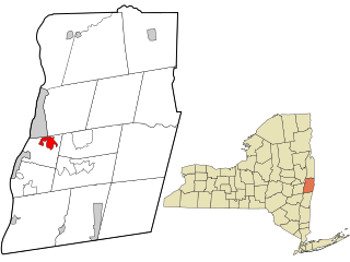
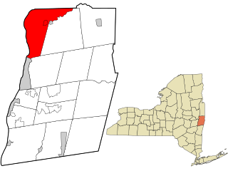
Berlin is a town in Rensselaer County, New York, United States. The population was 1,808 at the 2020 census. The town is named after Berlin in Germany, although natives pronounce the name differently, with the accent on the first syllable.

<span class="mw-page-title-main">Brunswick, New York</span> Town in New York, United States

Brunswick is a town in Rensselaer County, New York, United States. The municipality was originally settled in the early 18th century. During its history, it had been part of Albany County, Rensselaerswyck, and Troy, before its incorporation in 1807. It is bordered on the west by the city of Troy; on the north by Schaghticoke and Pittstown; on the east by Grafton; and on the south by Poestenkill and North Greenbush. The population was 12,581 at the 2020 census. The source of the town's name is not certain, though some claim it comes from the source of its first inhabitants from the province of Brunswick-Lüneburg in Germany.

<span class="mw-page-title-main">East Nassau, New York</span> Village in New York, United States

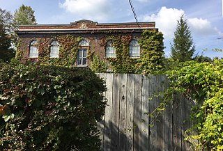
East Nassau is a village in Rensselaer County, New York, United States. The population was 587 at the 2010 census.

<span class="mw-page-title-main">Grafton, New York</span> Town in New York, United States

Grafton is a town in Rensselaer County, New York, United States. The population was 2,051 at the 2020 census. It is believed that the town received its name from Grafton, Vermont, where the first town supervisor, Nathaniel Dumbleton, was originally from. The town is an interior town near the north-central part of the county. NY Route 2 passes across the town.

<span class="mw-page-title-main">Hoosick, New York</span> Town in New York, United States

Hoosick is a town in Rensselaer County, New York, United States. The population was 6,711 at the 2020 census. It was named from the Hoosic River.

<span class="mw-page-title-main">North Greenbush, New York</span> Town in New York, United States

North Greenbush is a town in Rensselaer County, New York, United States. North Greenbush is located in the western part of the county. The population was 13,292 at the 2020 census.

<span class="mw-page-title-main">Petersburgh, New York</span> Town in New York, United States

Petersburgh is a town located in the northeast section of Rensselaer County, New York, United States. The population was 1,372 at the 2020 census. The town was named after an early settler named Peter Simmons.

<span class="mw-page-title-main">Pittstown, New York</span> Town in New York, United States

Pittstown is a town in Rensselaer County, New York, United States. The population was 5,540 at the 2020 census. It is in the northern part of the county.

<span class="mw-page-title-main">Wynantskill, New York</span> CDP in New York, United States

Wynantskill is a census-designated place (CDP) in Rensselaer County, New York, United States. The population was 4,050 at the 2020 census. Wynantskill is located at the northern town line and the northeastern corner of the town of North Greenbush. The community is a suburb of Troy. state route 66 is the main route through the community. Wynantskill has a major grocery store, several banks and restaurants, a craft beverage store, convenience stores, a post office, and a bowling alley, with almost all houses located on side streets off Main Ave. Other major roads are Whiteview Road, a primarily residential road that leads to US 4; and West Sand Lake Road.

Rensselaer Falls is a village located in St. Lawrence County, New York. As of the 2010 census, the village had a total population of 332. The current name came from mill owner Henry Van Rensselaer.

<span class="mw-page-title-main">Pownal, Vermont</span> Town in Vermont, United States

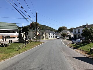
Pownal is a town in Bennington County, Vermont, United States. As of the 2020 census, the town population was 3,258. The town of Pownal includes the villages of Pownal, North Pownal, and Pownal Center.

<span class="mw-page-title-main">Green Island, New York</span> Town and village in New York, United States

Green Island is a coterminous town-village in Albany County, New York, United States, some 8 miles (13 km) north of Albany. Green Island is one of only five such town-village amalgamations in New York. The population was 2,934 at the 2020 census, and the ZIP code is 12183. While the town of Green Island was once an island, it was connected to the mainland on the west side of the Hudson River in the 1960s.

<span class="mw-page-title-main">Nassau (village), New York</span> Village in Rensselaer County, New York, US

Nassau is a village located in the Town of Nassau in Rensselaer County, New York, United States. The population was 1,133 at the 2010 census.

<span class="mw-page-title-main">Poestenkill, New York</span> Town in Rensselaer County, New York

Poestenkill is a town in Rensselaer County, New York, United States. The population was 4,322 at the 2020 census. The town is southeast of Troy and is centrally located in the county.

<span class="mw-page-title-main">Schaghticoke (village), New York</span> Village in New York, United States

Schaghticoke is a village in Rensselaer County, New York, United States. The population was 592 at the 2010 census.

<span class="mw-page-title-main">Schaghticoke, New York</span> Town in New York, United States

SchaghticokeSKAT-i-kohk is a town in Rensselaer County, New York, United States. The population was 7,445 at the 2020 census. It was named for the Schaghticoke, a Native American tribe formed in the seventeenth century from an amalgamation of remnant peoples of eastern New York and New England. The tribe has one of the oldest reservations in the United States, located in what is now Litchfield County, Connecticut. It has been recognized by the state of Connecticut but has not yet achieved federal recognition.

<span class="mw-page-title-main">Hoosic River</span> River in New York, United States

The Hoosic River, also known as the Hoosac, the Hoosick and the Hoosuck, is a 76.3-mile-long (122.8 km) tributary of the Hudson River in the northeastern United States. The different spellings are the result of varying transliterations of the river's original Algonquian name. It can be translated either as "the beyond place" or as "the stony place".

<span class="mw-page-title-main">Cambridge, New York</span> Town in New York, United States

Cambridge is a town in Washington County, New York, United States. It is part of the Glens Falls Metropolitan Statistical Area. The town population was 1,952 at the 2020 census.

References

  1. "ArcGIS REST Services Directory". United States Census Bureau. Retrieved September 20, 2022.
  2. "Landmarks of Rensselaer County" "History of Pittstown" chapter, published 1897
  3. http://www.timesunion.com/ASPStories/Story.asp?storyID=792671&newsdate=February 5, 2009&BCCode=MBTA [ dead link ]
  4. "Maps of Rensselaer County" published 1863 p.25
  5. "National Register of Historic Places Listings". Weekly List of Actions Taken on Properties: 8/23/13 through 8/30/13. National Park Service. September 6, 2013.
  6. "US Gazetteer files: 2010, 2000, and 1990". United States Census Bureau. February 12, 2011. Retrieved April 23, 2011.
  7. "Census of Population and Housing". Census.gov. Retrieved June 4, 2015.
  8. "U.S. Census website". United States Census Bureau . Retrieved January 31, 2008.

Further reading