
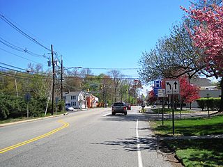
Queensbury is a town in Warren County, New York, United States. The population was 27,901 at the 2010 census.

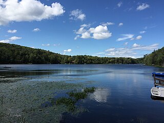
Bowman Lake State Park is a 653-acre (2.64 km2) state park located in Chenango County, New York. The park is located in the Town of McDonough, north of the community of East McDonough.
Deans is an unincorporated community located within South Brunswick Township in Middlesex County, New Jersey, United States.
New York State Route 73 (NY 73) is a 27.55-mile-long (44.34 km) state highway located entirely within Essex County, New York, in the United States. The highway begins at an intersection with NY 86 in the village of Lake Placid and ends at a junction with U.S. Route 9 (US 9) north of the hamlet of Underwood in the extreme southwestern corner of the town of Elizabethtown. NY 73 meanders through a mountainous region of Adirondack Park and passes by several named peaks, including Porter Mountain and Lower Wolfjaw Mountain. Along the way, the route has a short concurrency with NY 9N in the town of Keene.

New York State Route 164 (NY 164) is a short state highway located entirely in the town of Patterson in northeastern Putnam County, New York, in the United States. It is a short, two-lane back road that does not pass through any major populated areas and serves primarily as a connector between NY 311 and NY 22. NY 164 also allows for faster passage from Interstate 84 (I-84) to the Putnam Lake area via NY 311. The route was originally designated as NY 312 during the 1930s and later became part of NY 216. NY 164 was established on January 1, 1970, following the truncation of NY 216 to its current eastern terminus.
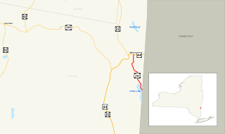
New York State Route 361 (NY 361) was a state highway located in Dutchess County, New York, in the United States. The southern terminus of the route was at the Connecticut state line, where it continued to Sharon, Connecticut, as Route 361. The northern terminus was at U.S. Route 44 (US 44) in Millerton. NY 361 was designated in April 1935 and removed from the state highway system and replaced with County Route 62 (CR 62) in 1980 as part of a large-scale highway maintenance swap between the New York State Department of Transportation and the Dutchess County highway department.
New York State Route 74 (NY 74) and Vermont Route 74 (VT 74) are state highways in the northeastern United States, connected by one of the last remaining cable ferries in North America. Together they extend for 34 miles (55 km) through Essex County, New York, and Addison County, Vermont. NY 74 begins at exit 28 off Interstate 87 (I-87) in the hamlet of Severance in the Adirondack Mountains region of the northern part of New York State. It extends 20.44 miles (32.89 km) to the western shore of Lake Champlain in Ticonderoga. There, the seasonal Fort Ticonderoga–Larrabees Point Ferry carries cars across the state border into Vermont, where VT 74 starts at the lake's eastern shore and terminates 13.26 miles (21.34 km) later at a junction with VT 30 in the town of Cornwall.
New York State Route 220 (NY 220) is a 19.26-mile-long (31.00 km) state highway located in Chenango County, New York, in the United States. It is signed as an east–west highway, but its actual routing wanders considerably from north to south as it proceeds across the county. The western terminus of NY 220 is at an intersection with NY 41 near the western county line in the town of Smithville. Its eastern terminus is the junction with NY 12 in Oxford village.

New York State Route 355 (NY 355) is an east–west state highway in Rensselaer County, New York, in the United States. The western terminus of the route is at an intersection with NY 66 in the town of North Greenbush. Its eastern terminus is at a junction with NY 351 in the hamlet of Poestenkill within the town of the same name. NY 355 originally consisted only of the section of the route between NY 66 and Spring Avenue; however, it was extended east to Postenkill hamlet in 1980, partially replacing NY 154.

County Road 26 in Franklin County, New York is the former New York State Route 99 (NY 99) state highway. The western terminus of the route was at an intersection with NY 30 in Duane. Its eastern terminus was at a junction with NY 3 near the Franklin community of Merrillsville. NY 99 was known as the Port Kent–Hopkinton Turnpike and maintained by Franklin County. The route was formerly co-designated with the state route. The narrow, winding route passed through isolated and heavily wooded areas of Adirondack Park.

Cumberland is a small unincorporated community located within Maurice River Township in Cumberland County, New Jersey, United States. Cumberland contains only a few hundred households, concentrated primarily on Route 49 and Hesstown/Port Elizabeth-Cumberland Road. The community is bordered by Millville and Port Elizabeth in Cumberland County and Estell Manor in Atlantic County. Cumberland is almost exclusively a residential and rural community with only two retail storefronts and several cottage industries. Most residents commute to nearby Millville, Vineland, Bridgeton, or one of the county's three prisons for employment.
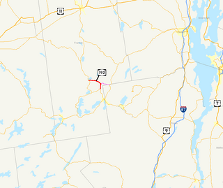
New York State Route 192 (NY 192) was a 7.35-mile (11.83 km) long east–west state highway in Franklin County, New York, in the United States. The western terminus of the route was at an intersection with NY 30 in the hamlet of Paul Smiths within the town of Brighton. Its eastern terminus was at a junction with NY 86 near the Adirondack Regional Airport in the town of Harrietstown. In between, NY 192 served the hamlet of Gabriels.
Bowmansville is a hamlet located in the town of Lancaster in Erie County, New York, United States. It is named after Benjamin Bowman, the owner of sawmills on Ellicott Creek in the center of the hamlet.

Poyntelle is a village in Preston Township, Wayne County, Pennsylvania, in the Lake Region of the Poconos. It was once a depot of the Scranton Division of the New York, Ontario & Western (O&W) Railway, but today, when it is known outside of its immediate vicinity, it is largely for being the location of Camps Westmont and Poyntelle Lewis Village, since the reputation and commercial reach of both, like those of most rural American summer camps, extend beyond the community in which the camps are physically located.
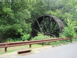
Bucks Mill is an unincorporated community located within Colts Neck Township, in Monmouth County, New Jersey, United States. Bucks Mill Road is the main road that passes north and south through the area; County Route 537 travels to the south of Bucks Mill, near the Hominy Hill Golf Course. Homes, equestrian facility and horse farms, and the township-owned Bucks Mill Recreational Area are located in the area. The settlement is named for Bucks Mill, a gristmill that derived its power from a watermill on the Yellow Brook. Originally built in 1854 and owned for many years by William Buck, Alfred Buck, and Garrett Buck, it was destroyed by a fire on October 30, 1967. The watermill is the only remaining artifact of the original complex and stands today on the side of Bucks Mill Road.

Edgebrook is a suburban neighborhood of New Brunswick in Middlesex County, New Jersey, United States adjacent to Westons Mill Pond

Fresh Ponds is an unincorporated community located within South Brunswick Township in Middlesex County, New Jersey, United States. It is located in a rural portion of the township at the intersection of Fresh Ponds Road and Davidson Mill Road. Forest land, farms, homes, and a church are located around the settlement.

Little Bowman Pond is a small glacial lake in the Taborton section of the Town of Sand Lake, Rensselaer County, New York, United States. The lake is located on a geologic formation known as the Rensselaer Plateau.
Big Bowman Pond is a small glacial lake in the Taborton section of the Town of Sand Lake, Rensselaer County, New York, United States. The lake is located on a geologic formation known as the Rensselaer Plateau.


