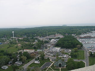
Put-in-Bay is a village located on South Bass Island in Put-in-Bay Township, Ottawa County, Ohio, United States 35 miles (56 km) east of Toledo. The population was 138 at the 2010 census.

The Bass Islands are three American islands in the western half of Lake Erie. They are north of Sandusky, Ohio, and south of Pelee Island, Ontario. South Bass Island is the largest of the islands, followed closely by North Bass Island and Middle Bass Island. They are located in Put-in-Bay Township, Ottawa County in the state of Ohio. Historically Middle Bass has also been called Ile de Fleurs and North Bass was known as Isle St. George.

Ballast Island is a small, 15-acre (0.049 km²) private island in Lake Erie, about one-quarter mile (0.4 km) northeast of the northeast tip of South Bass Island. It is known primarily as a navigation point for boats going to or from Put-in-Bay from the east. There are shoals between Ballast and South Bass, but there is a passage between known locally as "the wagon tracks". Ballast Island is partially owned by Mr. and Mrs. Americo Nerone and their five children ; there are currently 7 houses built on Ballast Island.
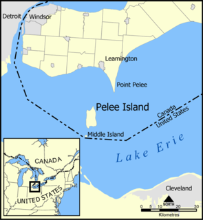
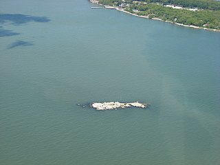
Middle Island is a small island, just 18.5 hectares in area. It is the southernmost point of land in Canada, located at 41°41'N, 82°41"W (41.685,-82.684), or about 41.7 degrees north latitude. It lies in Lake Erie, just south of Pelee Island, and is part of Point Pelee National Park. It forms part of the province of Ontario. The southernmost part of the island lies some 150 metres from the U. S. maritime boundary. The distance to the northernmost point of land in Canada—Cape Columbia, Ellesmere Island—is 4,640 kilometres.
Big Chicken Island is a small, flat, treeless island in Ontario located within Lake Erie. Although it is called an island, it is actually a reef. It is one of the three "chickens" that surround Hen Island, the other two being Chick Island and Little Chicken Island.
Chick Island is a small, flat, treeless island in Ontario located within Lake Erie. Although it is called an island, it is actually a reef. It is one of the three "chickens" that surround Hen Island, the other two being Big Chicken Island and Little Chicken Island.

Gibraltar Island is an island in Ohio, located within Lake Erie. This small 6.55-acre (0.026 km²) island is just offshore of South Bass Island. It is part of Put-in-Bay Township, Ottawa County, Ohio.

Mouse Island is a private island located in Lake Erie off the northern tip of Catawba Point in Ottawa County, Ohio, United States, near the city of Sandusky. It was formerly named "Ship Island", as denoted on early-19th-Century maps. It was later named Mouse Island for its small size. It is part of Catawba Island Township.

South Bass Island is a small island in western Lake Erie, and a part of Ottawa County, Ohio, United States. It is the southernmost of the three Bass Islands and located 3 miles (4.6 km) from the south shore of Lake Erie. It is the third largest island in the Lake Erie Islands, and is part of Put-in-Bay Township. In the bay of South Bass is Gibraltar Island, home to the Ohio State University's Stone Laboratory.
Starve Island is an island of the U.S. state of Ohio located in Lake Erie. The 2-acre (0.81 ha) island is about a mile (1.6 km) south of South Bass Island. In normal weather conditions it is visible for only a mile or two, as some rocks and a few shrubs poking up from the lake, and is the second smallest of the Lake Erie Islands. The island can be seen from the top of Perry's Victory and International Peace Memorial in Put-in-Bay.
Lost Ballast Island is an island in the U.S. state of Ohio, located in Lake Erie. The island was once a part of Ballast Island, but has since sunk into Lake Erie to become a reef. During periods of low water the island reappears. It is located in Put-in-Bay Township, Ottawa County, Ohio.
Gull Island may refer to:

Danbury Township is one of the twelve townships of Ottawa County, Ohio, United States. The 2000 census found 4,631 people in the township, 3,869 of whom lived in the unincorporated portions of the township.

Put-in-Bay Township is one of the twelve townships of Ottawa County, Ohio, United States. The 2000 census found 763 people in the township, 635 of whom lived in the unincorporated portions of the township.

Sugar Island of Ottawa County, Ohio, United States in southwestern Lake Erie. It is a private island and one of the smaller of the island group at 0.123 km². It lies just off the northwest shore of Middle Bass Island. It is located in Put-in-Bay Township, Ottawa County, Ohio.
The Isle St. George AVA is an American Viticultural Area located on North Bass Island, Ohio, an island in Lake Erie. The only town on the Ottawa County island is also called Isle Saint George, although the "Saint" in the AVA name must be abbreviated as "St." to be used on wine labels. Over half of the island is planted to grapevines. Lake Erie is warmer than the other Great Lakes, providing a moderating and warming effect on the local climate. Temperatures on the island during the growing season can be warmer than on the mainland. Cool climate varietals such as Catawba, Delaware, Gewürztraminer, Pinot noir, and Riesling are the most important in Isle St. George.

Green Island is a small 17-acre (0.07 km²) island of the U.S. state of Ohio, in Lake Erie. It is located approximately three miles southwest of Put-in-Bay. It is part of Put-in-Bay Township, in Ottawa County.
Buckeye Island is a small island of the U.S. state of Ohio, in Lake Erie. It is located just off shore of the northeast tip of South Bass Island, in Put-in-Bay Township, Ottawa County. It was seasonally populated early in the 20th century. It is privately owned, and has been by the same family since 1916.
Little Chicken Island is a small, flat, treeless island in Ontario located within Lake Erie. Although it is called an island, it is actually a reef. It is one of the three "chickens" that surround Hen Island, the other two being Big Chicken Island and Chick Island.

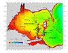
The Vacationland region of Ohio - billed as such for being known primarily as a major summertime tourist destination - is the area that is generally considered to be in the north central part of the state, and along the western half of the Lake Erie shoreline, specifically the counties of Erie, Huron, Ottawa, and Sandusky.