Lake Ontario is one of the five Great Lakes of North America. It is surrounded on the north, west, and southwest by the Canadian province of Ontario, and on the south and east by the American state of New York, whose water boundaries meet in the middle of the lake. Ontario, Canada's most populous province, was named for the lake. Many of Ontario's most populous cities, including Toronto, Canada's most populous city, and Hamilton, are on the lake's northern or western shores. In the Huron language, the name Ontarí'io means "Lake of Shining Waters". Its primary inlet is the Niagara River from Lake Erie. The last in the Great Lakes chain, Lake Ontario serves as the outlet to the Atlantic Ocean via the Saint Lawrence River. It is the only Great Lake not to border the state of Michigan.
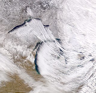
Lake-effect snow is produced during cooler atmospheric conditions when a cold air mass moves across long expanses of warmer lake water, warming the lower layer of air which picks up water vapor from the lake, rises up through the colder air above, freezes and is deposited on the leeward (downwind) shores.
The Niagara River is a river that flows north from Lake Erie to Lake Ontario. It forms part of the border between the province of Ontario in Canada and the state of New York in the United States. There are differing theories as to the origin of the river's name. According to Iroquoian scholar Bruce Trigger, Niagara is derived from the name given to a branch of the locally residing native Neutral Confederacy, who are described as being called the Niagagarega people on several late-17th-century French maps of the area. According to George R. Stewart, it comes from the name of an Iroquois town called Ongniaahra, meaning "point of land cut in two".

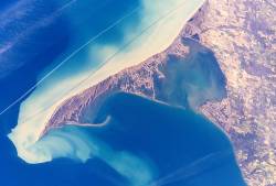
Point Pelee National Park is a national park in Essex County in southwestern Ontario, Canada where it extends into Lake Erie. The word pelée is French for 'bald'. Point Pelee consists of a peninsula of land, mainly of marsh and woodland habitats, that tapers to a sharp point as it extends into Lake Erie. Middle Island, also part of Point Pelee National Park, was acquired in 2000 and is just north of the Canada–United States border in Lake Erie. Point Pelee is the southernmost point of mainland Canada, and is located on a foundation of glacial sand, silt and gravel that bites into Lake Erie. This spit of land is slightly more than seven kilometres long by 4.5 kilometres (2.8 mi) wide at its northern base. Established in 1918, Point Pelee was the first national park in Canada to be established for conservation. It was designated as a Ramsar site on 27 May 1987.

Erie is a city on the south shore of Lake Erie and the county seat of Erie County, Pennsylvania, United States. Named for the lake and the Native American Erie people who lived in the area until the mid-17th century, Erie is the fourth-largest city in Pennsylvania, as well as the largest city in Northwestern Pennsylvania, with a population of 101,786 at the 2010 census. The estimated population in 2016 had decreased to 98,593. The Erie metropolitan area, equivalent to all of Erie County, consists of 276,207 residents. The Erie-Meadville, PA Combined Statistical Area has a population of 369,331, as of the 2010 Census.

The Mohawk River is a 149-mile-long (240 km) river in the U.S. state of New York. It is the largest tributary of the Hudson River. The Mohawk flows into the Hudson in Cohoes, New York, a few miles north of the city of Albany. The river is named for the Mohawk Nation of the Iroquois Confederacy. It is a major waterway in north-central New York.

The Maumee River is a river running from northeastern Indiana into northwestern Ohio and Lake Erie in the United States. It is formed at the confluence of the St. Joseph and St. Marys rivers, where Fort Wayne, Indiana, has developed, and meanders northeastwardly for 137 miles (220 km) through an agricultural region of glacial moraines before flowing into the Maumee Bay of Lake Erie. The city of Toledo is located at the mouth of the Maumee. The Maumee was designated an Ohio State Scenic River on July 18, 1974. The Maumee watershed is Ohio’s breadbasket; it is two-thirds farmland, mostly corn and soybeans. It is the largest watershed of any of the rivers feeding the Great Lakes, and supplies five percent of Lake Erie’s water.
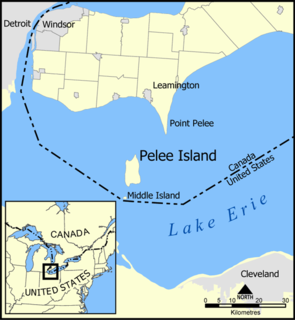
Pelee Island, Ontario, Canada, is an island in the western half of Lake Erie. Pelee Island is connected to the Canadian and United States mainland by ferry service. At 42 km2 (16 sq mi), Pelee Island is the largest island in Lake Erie and the southernmost populated point in Canada. An Ontario Historical Plaque was erected by the province to commemorate the development of Pelee Island's role in Ontario's heritage. Nearby Middle Island is the southernmost point of land in Canada.

The Snowbelt is the region near the Great Lakes in North America where heavy snowfall in the form of lake-effect snow is particularly common. Snowbelts are typically found downwind of the lakes, principally off the eastern and southern shores. Lake-effect snow occurs when cold air moves over warmer water, taking up moisture that later precipitates as snow when the air moves over land and cools. The lakes produce snowsqualls and persistently cloudy skies throughout the winter, as long as air temperatures are colder than water temperatures, or until a lake freezes over.

Gibraltar Island is an island in Ohio, located within Lake Erie. This small 6.55-acre (0.026 km²) island is just offshore of South Bass Island. It is part of Put-in-Bay Township, Ottawa County, Ohio.

South Bass Island is a small island in western Lake Erie, and a part of Ottawa County, Ohio, United States. It is the southernmost of the three Bass Islands and located 3 miles (4.6 km) from the south shore of Lake Erie. It is the third largest island in the Lake Erie Islands, and is part of Put-in-Bay Township. In the bay of South Bass is Gibraltar Island, home to the Ohio State University's Stone Laboratory.

Presque Isle State Park is a 3,112-acre (1,259 ha) Pennsylvania State Park on an arching, sandy peninsula that juts into Lake Erie, 4 miles (6 km) west of the city of Erie, in Millcreek Township, Erie County, Pennsylvania, in the United States. The peninsula sweeps northeastward, surrounding Presque Isle Bay along the park's southern coast. It has 13 miles (21 km) of roads, 21 miles (34 km) of recreational trails, 13 beaches for swimming, and a marina. Popular activities at the park include swimming, boating, hiking, biking, and birdwatching.

Catawba Island Township is one of the twelve townships of Ottawa County, Ohio, United States. The 2000 census found 3,157 people in the township.

State Route 575 is a 2.60-mile-long (4.18 km) north–south state highway located in the northern portion of the U.S. state of Ohio. The route is located entirely within the western half of Kelleys Island, one of the Lake Erie Islands. The highway runs from its southern terminus at the Neumans Ferry Dock at the south end of the island to its northern terminus at a T-intersection with Division Street in the northern part of the island. This highway, along with SR 357 on South Bass Island, is isolated from the rest of Ohio, and all other Ohio state highways. The route was created in 1937 and has not changed since.

Gard Island is a small island of the U.S. state of Michigan, located at the north end of Maumee Bay in Lake Erie. It is located just off shore of the northeast tip of the "Lost Peninsula", an exclave created by the Michigan-Ohio boundary line. It is part of Erie Township in Monroe County. It was known to have been inhabited by Native Americans at one point, but never by settlers.

Ryerson's Island is an island in Ontario, Canada, located in Lake Erie north of Long Point. The island is named for its first owner, Colonel Joseph Ryerson (1764-1854), who was a Loyalist sniper from New Jersey in a unit that tried to kill George Washington, later serving with the Prince of Wales American Regiment and father of Egerton Ryerson.
Second Island is an island in Ontario, Canada, located in Lake Erie north of Long Point. The island was never inhabited, and is located between Ryerson's Island and Snow Island, which together with Second Island are three of the more notable islands near Long Point.