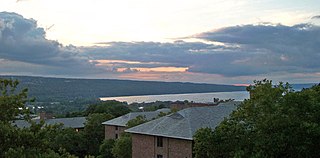
Cayuga Lake is the longest of central New York's glacial Finger Lakes, and is the second largest in surface area and second largest in volume. It is just under 40 miles (64 km) long. Its average width is 1.7 miles (2.7 km), and it is 3.5 mi wide (5.6 km) at its widest point near Aurora. It is approximately 435 ft deep (133 m) at its deepest point.
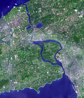
The Niagara River is a river that flows north from Lake Erie to Lake Ontario. It forms part of the border between the province of Ontario in Canada and the state of New York in the United States. There are differing theories as to the origin of the river's name. According to Iroquoian scholar Bruce Trigger, Niagara is derived from the name given to a branch of the locally residing native Neutral Confederacy, who are described as being called the Niagagarega people on several late-17th-century French maps of the area. According to George R. Stewart, it comes from the name of an Iroquois town called Ongniaahra, meaning "point of land cut in two".

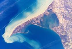
Point Pelee National Park is a national park in Essex County in southwestern Ontario, Canada where it extends into Lake Erie. The word pelée is French for 'bald'. Point Pelee consists of a peninsula of land, mainly of marsh and woodland habitats, that tapers to a sharp point as it extends into Lake Erie. Middle Island, also part of Point Pelee National Park, was acquired in 2000 and is just north of the Canada–United States border in Lake Erie. Point Pelee is the southernmost point of mainland Canada, and is located on a foundation of glacial sand, silt and gravel that bites into Lake Erie. This spit of land is slightly more than seven kilometres long by 4.5 kilometres (2.8 mi) wide at its northern base. Established in 1918, Point Pelee was the first national park in Canada to be established for conservation. It was designated as a Ramsar site on 27 May 1987.
Long Point is a sand spit and medium-sized hamlet on the north shore of Lake Erie, part of Norfolk County in the province of Ontario, Canada.
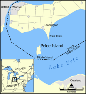
Pelee Island, Ontario, Canada, is an island in the western half of Lake Erie. Pelee Island is connected to the Canadian and United States mainland by ferry service. At 42 km2 (16 sq mi), Pelee Island is the largest island in Lake Erie and the southernmost populated point in Canada. An Ontario Historical Plaque was erected by the province to commemorate the development of Pelee Island's role in Ontario's heritage. Nearby Middle Island is the southernmost point of land in Canada.

The Snowbelt is the region near the Great Lakes in North America where heavy snowfall in the form of lake-effect snow is particularly common. Snowbelts are typically found downwind of the lakes, principally off the eastern and southern shores. Lake-effect snow occurs when cold air moves over warmer water, taking up moisture that later precipitates as snow when the air moves over land and cools. The lakes produce snowsqualls and persistently cloudy skies throughout the winter, as long as air temperatures are colder than water temperatures, or until a lake freezes over.

Gibraltar Island is an island in Ohio, located within Lake Erie. This small 6.55-acre (0.026 km²) island is just offshore of South Bass Island. It is part of Put-in-Bay Township, Ottawa County, Ohio.

Gull Island Shoal is a former island of the U.S. state of Ohio, located in Lake Erie. Although it still appears on some old maps of Lake Erie as "Gull Island", it is no longer an island, but rather is now just a shoal south of Middle Island. The island was last seen above water 120 years ago.

South Bass Island is a small island in western Lake Erie, and a part of Ottawa County, Ohio, United States. It is the southernmost of the three Bass Islands and located 3 miles (4.6 km) from the south shore of Lake Erie. It is the third largest island in the Lake Erie Islands, and is part of Put-in-Bay Township. In the bay of South Bass is Gibraltar Island, home to the Ohio State University's Stone Laboratory.

Amherstburg Royal Naval Dockyard was a Provincial Marine and then a Royal Navy yard from 1796 to 1813 in Amherstburg, Ontario, situated on the Detroit River. The yard comprised blockhouses, storehouses, magazine, wood yard and wharf. The yard was established in 1796 to support the Upper Canada Provincial Marine after Great Britain ceded a pre-existing shipyard on the Detroit River to the United States. Amherstburg Royal Naval Dockyard constructed four warships for the Lake Erie detachment of the Provincial Marine before and during the War of 1812. In 1813 the dockyard was abandoned and destroyed when the British retreated and never reopened. In 1928, the site was designated a National Historic Site of Canada.

Catawba Island Township is one of the twelve townships of Ottawa County, Ohio, United States. The 2000 census found 3,157 people in the township.

State Route 575 is a 2.60-mile-long (4.18 km) north–south state highway located in the northern portion of the U.S. state of Ohio. The route is located entirely within the western half of Kelleys Island, one of the Lake Erie Islands. The highway runs from its southern terminus at the Neumans Ferry Dock at the south end of the island to its northern terminus at a T-intersection with Division Street in the northern part of the island. This highway, along with SR 357 on South Bass Island, is isolated from the rest of Ohio, and all other Ohio state highways. The route was created in 1937 and has not changed since.

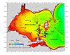
The geography of New York state varies widely. Most of New York is dominated by farms, forests, rivers, mountains, and lakes. New York's Adirondack Park is larger than any U.S. National Park in the contiguous United States. Niagara Falls, on the Niagara River as it flows from Lake Erie to Lake Ontario, is a popular attraction. The Hudson River begins near Lake Tear of the Clouds and flows south through the eastern part of the state without draining lakes George or Champlain. Lake George empties at its north end into Lake Champlain, whose northern end extends into Canada, where it drains into the Richelieu River and then the St. Lawrence. Four of New York City's five boroughs are on the three islands at the mouth of the Hudson River: Manhattan Island, Staten Island, and Brooklyn and Queens on Long Island.

Gard Island is a small island of the U.S. state of Michigan, located at the north end of Maumee Bay in Lake Erie. It is located just off shore of the northeast tip of the "Lost Peninsula", an exclave created by the Michigan-Ohio boundary line. It is part of Erie Township in Monroe County. It was known to have been inhabited by Native Americans at one point, but never by settlers.
Indian Island is a small island of the U.S. state of Michigan, located at the north end of Maumee Bay in Lake Erie. It is located just off shore of the northeast tip of the "Lost Peninsula", an exclave created by the Michigan-Ohio boundary line. It is part of Erie Township in Monroe County.

Ryerson's Island is an island in Ontario, Canada, located in Lake Erie north of Long Point. The island is named for its first owner, Colonel Joseph Ryerson (1764-1854), who was a Loyalist sniper from New Jersey in a unit that tried to kill George Washington, later serving with the Prince of Wales American Regiment and father of Egerton Ryerson.
Snow Island is an island in Ontario, Canada, located in Lake Erie north of Long Point. The island was never inhabited, and is located southeast of both Ryerson's Island and Second Island, which together with Snow Island are three of the more notable islands near Long Point.
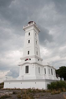
The Point Abino Light Tower is a lighthouse on the rocky north shore of Lake Erie at the southern tip of Point Abino peninsula west of Crystal Beach, Ontario, Canada. The Greek Revival white square tower with red accents is attached to the fog alarm building, and a lighthouse keeper's residence is located on the shore to the north.