Related Research Articles

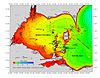
Erie County is a county along the shore of Lake Erie in western New York State. As of the 2020 census, the population was 954,236. The county seat is Buffalo, which makes up about 28% of the county's population. Both the county and Lake Erie were named for the regional Iroquoian language-speaking Erie tribe of Native Americans, who lived in the area before 1654. They were later pushed out by the more powerful Iroquoian nations tribes.
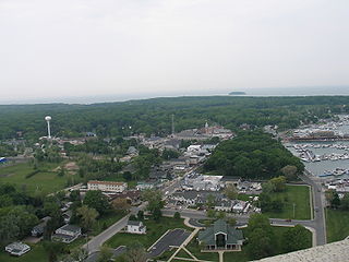
Put-in-Bay is a village located on South Bass Island in Put-in-Bay Township, Ottawa County, Ohio, United States, 35 miles (56 km) east of Toledo. The population was 154 at the 2020 census.
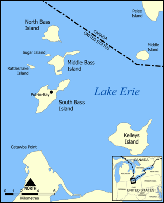
The Bass Islands are three American islands in the western half of Lake Erie. They are north of Sandusky, Ohio, and south of Pelee Island, Ontario. South Bass Island is the largest of the islands, followed closely by North Bass Island and Middle Bass Island. They are located in Put-in-Bay Township, Ottawa County in the state of Ohio. Historically Middle Bass has also been called Ile de Fleurs and North Bass was known as Isle St. George.

Pelee Island is an island in the Canadian province of Ontario. It is located in the western half of Lake Erie. At 42 km2 (16 sq mi), Pelee Island is the largest island in Lake Erie and the southernmost populated point in Canada. An Ontario Historical Plaque was erected by the province to commemorate the development of Pelee Island's role in Ontario's heritage. Nearby Middle Island is the southernmost point of land in Canada.

Middle Island is a small island, just 18.5 hectares in area. It is the southernmost point of land in Canada, located at 41°41'N, 82°41"W (41.685,-82.684), or about 41.7 degrees north latitude. It lies in Lake Erie, just south of Pelee Island, and is part of Point Pelee National Park. It forms part of the province of Ontario. The southernmost part of the island lies some 150 metres from the U.S. maritime boundary. The distance to the northernmost point of land in Canada—Cape Columbia, Ellesmere Island—is 4,640 kilometres.
Chick Island is a small, flat, treeless island in Ontario located within Lake Erie. Although it is called an island, it is actually a reef. It is one of the three "chickens" that surround Hen Island, the other two being Big Chicken Island and Little Chicken Island.

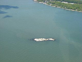
Gibraltar Island is an island in Ohio, located within Lake Erie. This small 6.55-acre (0.026 km²) island is just offshore of South Bass Island. It is part of Put-in-Bay Township, Ottawa County, Ohio.

Gull Island Shoal is a former island of the U.S. state of Ohio, located in Lake Erie. Although it still appears on some old maps of Lake Erie as "Gull Island", it is no longer an island, but rather is now just a shoal south of Middle Island. The island was last seen above water 120 years ago.

Mouse Island is a private island located in Lake Erie off the northern tip of Catawba Point in Ottawa County, Ohio, United States, near the city of Sandusky. It was formerly named "Ship Island", as denoted on early-19th-Century maps. It was later named Mouse Island for its small size. It is part of Catawba Island Township.

North Bass Island is an island of the U.S. state of Ohio located in Lake Erie. A small unincorporated community, Isle Saint George, is on the island. The North Bass Island Post Office was established on May 25, 1864, and the name changed to Isle Saint George Post Office on March 2, 1874. The Isle Saint George ZIP code 43436 provides PO Box service. The island is equidistant to Port Clinton, OH and Kingsville, Ontario, Canada.

South Bass Island is a small island in western Lake Erie, and a part of Ottawa County, Ohio, United States. It is the southernmost of the three Bass Islands and located 3 miles (4.6 km) from the south shore of Lake Erie. It is the third largest island in the Lake Erie Islands, and is part of Put-in-Bay Township. In the bay of South Bass is Gibraltar Island, home to the Ohio State University's Stone Laboratory.
Starve Island is an island of the U.S. state of Ohio located in Lake Erie. The 2-acre (0.81 ha) island is about a mile (1.6 km) south of South Bass Island. In normal weather conditions it is visible for only a mile or two, as some rocks and a few shrubs poking up from the lake, and is the second smallest of the Lake Erie Islands. The island can be seen from the top of Perry's Victory and International Peace Memorial in Put-in-Bay.

Lost Ballast Island is an island in the U.S. state of Ohio, located in Lake Erie. The island was once a part of Ballast Island, but was separated into a separate island by a strong storm. Historically, the island was not inhabited by humans, though it was a site for Nerodia sipedon insularum. Since the 1970's has sunk into Lake Erie to become a reef. During periods of low water the island reappears. It is located in Put-in-Bay Township, Ottawa County, Ohio.

Danbury Township is one of the twelve townships of Ottawa County, Ohio, United States. The 2000 census found 4,631 people in the township, 3,869 of whom lived in the unincorporated portions of the township.

Put-in-Bay Township is one of the twelve townships of Ottawa County, Ohio, United States. The 2000 census found 763 people in the township, 635 of whom lived in the unincorporated portions of the township.

Green Island is a small 17-acre (0.07 km²) island of the U.S. state of Ohio, in Lake Erie. It is located approximately three miles southwest of Put-in-Bay. It is part of Put-in-Bay Township, in Ottawa County.
Little Chicken Island is a small, flat, treeless island in Ontario located within Lake Erie. Although it is called an island, it is actually a reef. It is one of the three "chickens" that surround Hen Island, the other two being Big Chicken Island and Chick Island.
Pelee Island Winery is a winery in Kingsville, Ontario, Canada. They have over 700-acre (2.8 km2) of vineyards on Pelee Island, which is in the South Islands Sub-Appellation of the Lake Erie North Shore Appellation of Ontario along the shores of Lake Erie. https://www.vqaontario.ca/Appellations/LakeErieNorthShore
References
- ↑ Gora, Michael (2004). "How Many Islands Are There in Lake Erie?" (PDF). Lake Erie Islands Historical Society. Archived from the original (PDF) on June 19, 2019. Retrieved March 19, 2014.