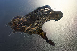
Kafralu Island was a man-made island built in 1911 [1] on a sandbar alongside Cedar Point in Northeast Ohio.
Kafralu Island was a man-made island built in 1911 [1] on a sandbar alongside Cedar Point in Northeast Ohio.
Louis E. Wagner and his sons built Kafralu Island over a course of twenty years by hauling in logs and fill. Wagner coined the name Kafralu by combining the name of his wife (Katherine) with the names of his sons (Frank and Louis). [2]
Wagner built cottages on the island, which were rented out during the summer months to tourists and other guests that would use the island for hunting, fishing, and vacations. [2]
Kafralu Island, up until 1939 was never registered with the local real estate tax office. When it was discovered that it had no legal owner by Cedar Point Company they filed an original deed to the property, and the land was taken from Louis as he was physically removed from the property and the cottages destroyed to make way for the new Cedar Park expressway. As this was the family sole source of income, the family became destitute as no compensation was ever given to the family. Louis died shortly after losing his island. Today the island can still be seen while traveling the Cedar Point Causeway as the large grassy wooded area on the west side.
On September 11, 2016, Kafralu Island was the site of the worst auto accident to happen on Cedar Point property when a male driver went off the right side of the road before over correcting and going left of center, striking two oncoming vehicles. The driver was ejected from his vehicle and found along a densely wooded part of the island. The driver was pronounced dead at nearby Firelands Medical Center and two young women were also treated and released. [2]

Erie Township is a civil township of Monroe County in the U.S. state of Michigan. The population was 4,517 at the 2010 census. Sharing a southern border with the city of Toledo about 35 miles (56.3 km) south of the city of Detroit, the township is one of the southernmost areas included in the Detroit–Warren–Ann Arbor Combined Statistical Area.
Kelleys Island is both a village in Erie County, Ohio, and the island which it fully occupies in Lake Erie. The British originally called it Sandusky Island. Later the United States took it over and officially designated it as Island Number 6 and Cunningham Island. It was renamed as Kelleys Island in 1840 by brothers Datus and Irad Kelley, who had purchased nearly the entire island.

Marblehead is a village in Ottawa County, Ohio, United States. The population was 903 at the 2010 census.

Port Clinton is a city in and the county seat of Ottawa County, located at the mouth of the Portage River on Lake Erie, about 44 miles east of Toledo. The population was 6,056 at the 2010 census.
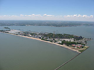
Cedar Point is a 364-acre (147 ha) amusement park located on a Lake Erie peninsula in Sandusky, Ohio, United States. Opened in 1870, it is considered the second-oldest operating amusement park in the U.S. behind Lake Compounce. Cedar Point is owned and operated by Cedar Fair and is the flagship of the amusement park chain. Known as "America's Roller Coast", the park features 15 roller coasters – fourth-most in the world with Six Flags Great America, behind Canada's Wonderland and Energylandia (17), as well as Six Flags Magic Mountain (20). Cedar Point's most recent roller coaster, Steel Vengeance, opened to the public on May 5, 2018.
Hammond is a town in St. Lawrence County, New York, United States. The population was 1,191 at the 2010 census. The name is derived from early land owner Abijah Hammond.
Indian Lake is a reservoir in Logan County, western Ohio, in the United States. It is approximately 20 miles (32 km) southeast of Lima. It is fed by the north and south forks of the Upper Great Miami River, Cherokee Mans Run, Blackhawk Creek, and Van Horn Creek. The outlet of the lake, at the bulkhead or "spillway" built in the 1850s by Irish laborers, is the beginning of the Great Miami River. At 5,104 acres (2,066 ha), Indian Lake is the second largest inland lake in Ohio.
Grymes Hill is a 374 feet (114 m) tall hill formed of serpentine rock on Staten Island, New York. It is the second highest natural point on the island and in the five boroughs of New York City. The neighborhood of the same name encompasses an area of 0.894 square miles (2.32 km2) and has a population of 8,263 people. The hill also includes parts of the Silver Lake neighborhood. The area includes part of zip codes 10301 and 10304.

Ballast Island is a small, 15-acre (0.049 km²) private island in Lake Erie, about one-quarter mile (0.4 km) northeast of the northeast tip of South Bass Island. It is known primarily as a navigation point for boats going to or from Put-in-Bay from the east. There are shoals between Ballast and South Bass, but there is a passage between known locally as "the wagon tracks".

Gibraltar Island is an island in Ohio, located within Lake Erie. This small 6.55-acre (0.026 km²) island is just offshore of South Bass Island. It is part of Put-in-Bay Township, Ottawa County, Ohio.

Mouse Island is a private island located in Lake Erie off the northern tip of Catawba Point in Ottawa County, Ohio, United States, near the city of Sandusky. It was formerly named "Ship Island", as denoted on early-19th-Century maps. It was later named Mouse Island for its small size. It is part of Catawba Island Township.

South Bass Island is a small island in western Lake Erie, and a part of Ottawa County, Ohio, United States. It is the southernmost of the three Bass Islands and located 3 miles (4.6 km) from the south shore of Lake Erie. It is the third largest island in the Lake Erie Islands, and is part of Put-in-Bay Township. In the bay of South Bass is Gibraltar Island, home to the Ohio State University's Stone Laboratory.
Sandusky Bay is a bay on Lake Erie in northern Ohio, formed at the mouth of the Sandusky River. It was identified as Lac Sandouské on a 1718 French map, with early variations recorded that suggest the name was derived from Native American languages. The Thomas A. Edison Memorial Bridge was constructed across it in the 20th century to connect highways in Erie and Ottawa counties.

Lake Wawasee is a large, natural, freshwater lake southeast of Syracuse in Kosciusko County, Indiana. It is the largest natural lake within Indiana's borders.
Sandusky is a city in and the county seat of Erie County, Ohio, United States. Situated along the shores of Lake Erie in the northern part of the state, Sandusky is located roughly midway between Toledo and Cleveland. According to 2020 census, the city had a population of 25,095, and the Sandusky micropolitan area had 75,622 residents.
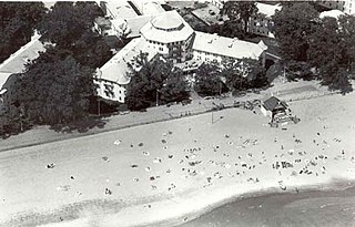
The Hotel Breakers, opened in 1905, is a large historic Lake Erie resort hotel located at 1 Cedar Point Drive in the Cedar Point amusement park in Sandusky, Ohio.

Buckeye Island is a small island of the U.S. state of Ohio, in Lake Erie. It is located just off shore of the northeast tip of South Bass Island, in Put-in-Bay Township, Ottawa County. It was seasonally populated early in the 20th century. The island was noted for the Willow trees found there. It is privately owned, and has been by the same family since 1916.

The Cedar Point & Lake Erie Railroad is a 3 ft narrow-gauge heritage railroad and amusement park attraction located in the Cedar Point amusement park in Sandusky, Ohio. The railroad opened in 1963, making it one of the oldest operating rides at Cedar Point. It consists of a total of five steam locomotives, with four of them in operating condition. In 2013, the railroad celebrated its 50th anniversary in operation.
Mission Point is located on the southeast side of Mackinac Island, Michigan. It is approximately 21 acres (8.5 ha) in size between Robinson's Folly and the jetty terminating near Franks Street. The Island has a history of documented European development beginning with French Jesuit missionaries landing at the point in 1634, less than two decades after the Pilgrims landed at Plymouth Rock on the East Coast of North America.

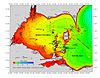
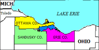
The Vacationland region of Ohio - billed as such for being known primarily as a major summertime tourist destination - is the area that is generally considered to be in the north central part of the state, and along the western half of the Lake Erie shoreline, specifically the counties of Erie, Huron, Ottawa, and Sandusky.
Coordinates: 41°27′53″N82°40′25″W / 41.464719°N 82.673476°W
| | This Erie County, Ohio state location article is a stub. You can help Wikipedia by expanding it. |