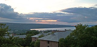
Cayuga Lake (,,) is the longest of central New York's glacial Finger Lakes, and is the second largest in surface area and second largest in volume. It is just under 39 miles (63 km) long. Its average width is 1.7 miles (2.8 km), and it is 3.5 mi wide (5.6 km) at its widest point, near Aurora. It is approximately 435 ft deep (133 m) at its deepest point, and has over 95 miles (153 km) of shoreline.

The Great Lakes, also called the Great Lakes of North America, are a series of large interconnected freshwater lakes in the mid-east region of North America that connect to the Atlantic Ocean via the Saint Lawrence River. There are five lakes, which are Superior, Michigan, Huron, Erie, and Ontario and are in general on or near the Canada–United States border. Hydrologically, lakes Michigan and Huron are a single body joined at the Straits of Mackinac. The Great Lakes Waterway enables modern travel and shipping by water among the lakes.

Lake Erie ( "eerie") is the fourth largest lake by surface area of the five Great Lakes in North America and the eleventh-largest globally. It is the southernmost, shallowest, and smallest by volume of the Great Lakes and therefore also has the shortest average water residence time. At its deepest point Lake Erie is 210 feet (64 m) deep.

Port Clinton is a city in and the county seat of Ottawa County, located at the mouth of the Portage River on Lake Erie, about 44 miles east of Toledo. The population was 6,025 at the 2020 census.
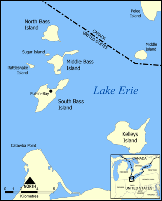
The Bass Islands are three American islands in the western half of Lake Erie. They are north of Sandusky, Ohio, and south of Pelee Island, Ontario. South Bass Island is the largest of the islands, followed closely by North Bass Island and Middle Bass Island. They are located in Put-in-Bay Township, Ottawa County in the state of Ohio. Historically Middle Bass has also been called Ile de Fleurs and North Bass was known as Isle St. George.

Lake St. Clair is a freshwater lake that lies between the Canadian province of Ontario and the U.S. state of Michigan. It was named in 1679 by French Catholic explorers after Saint Clare of Assisi, on whose feast day they first saw the lake.

Pelee Island is an island in the Canadian province of Ontario. It is located in the western half of Lake Erie. At 42 km2 (16 sq mi), Pelee Island is the largest island in Lake Erie and the southernmost populated point in Canada. An Ontario Historical Plaque was erected by the province to commemorate the development of Pelee Island's role in Ontario's heritage. Nearby Middle Island is the southernmost point of land in Canada.
Rattlesnake Island is an 85-acre (34 ha) island located on Lake Erie near Put-In-Bay, 11 miles (18 km) northeast of Port Clinton, Ohio. It is part of Put-in-Bay Township, in Ottawa County. It is one of several islands known as the Lake Erie Islands. The name Rattlesnake comes from the actual rattlesnakes that formerly inhabited the island,.

The Detroit River International Wildlife Refuge is the only international wildlife refuge in North America. Established in 2001 and managed jointly by the United States Fish and Wildlife Service and the Canadian Wildlife Service, it is located in a major metropolitan area. The Detroit River International Wildlife Refuge is one of over 540 National Wildlife Refuges managed by the U.S. Fish and Wildlife Service within the Department of the Interior. It occupies 7.88 square miles (20.41 km2) of scattered property but has drawn boundaries for further expansion.
Big Chicken Island is a small, flat, treeless island in Ontario located within Lake Erie. Although it is called an island, it is actually a reef. It is one of the three "chickens" that surround Hen Island, the other two being Chick Island and Little Chicken Island.
Chick Island is a small, flat, treeless island in Ontario located within Lake Erie. Although it is called an island, it is actually a reef. It is one of the three "chickens" that surround Hen Island, the other two being Big Chicken Island and Little Chicken Island.
Wheatley is a community in Southwestern Ontario, Canada, within the municipality of Chatham-Kent. It lies about 12 kilometres (7 mi) east of Leamington. Nearby parks include Two Creeks Conservation Area, which has 15 km of hiking and bicycling paths, Kopegaron Woods Conservation Area, Hillman Marsh Conservation Area and Point Pelee National Park. Rondeau Provincial Park is only a forty-five-minute drive to the east. It also boasts Wheatley Provincial Park, home to the endangered Blue Racer snake, which can only be found in the park as well as the Point Pelee National Park and on Pelee Island.

Mohawk Island is a small island in the northeast of Lake Erie, in Haldimand County, Ontario, Canada. It is composed of limestone with almost no vegetation, and is close to the water level. It was formerly known as Gull Island and contains the ruins of the Gull Island Lighthouse which was built in 1848 to guide ships into the Welland Canal at Port Maitland. In 1933, the lighthouse was automated to no longer require a human keeper and lost significance in 1934 due to the realignment of the canal at Port Colborne. It was decommissioned in 1969 when the mechanism was destroyed by a fire. The lighthouse is located close to the shore of Rock Point Provincial Park.

Presque Isle Bay is a natural bay located off the coast of Erie, Pennsylvania, United States. Its 5.8-square-mile (15 km2) embayment is about 4.6 miles (7.4 km) in length, about 1.8 mi (2.9 km) across at its widest point, and an average depth of about 20 feet (6.1 m). The bay is at an elevation of 571 ft above sea level. It is bounded on the north and west by a recurved peninsula that makes up Presque Isle State Park. On the south, the bay is edged by the urban Erie shoreline, which hosts the Port of Erie Marine Terminal, as well as an assortment of parks, tourist attractions and marinas such as the Erie Yacht Club. Fishing, water skiing, swimming, and boating, are a few examples of common activities among visitors who come to appreciate this natural bay for its sheltered waters and captivating views of Erie’s historic neighborhoods and landmarks. A small channel on the east provides a shipping lane into and out of Lake Erie. Cascade Creek, Garrison Run, Mill Creek, and surface runoff drain the lands of the Presque Isle Bay Watershed into the bay.
Little Chicken Island is a small, flat, treeless island in Ontario located within Lake Erie. Although it is called an island, it is actually a reef. It is one of the three "chickens" that surround Hen Island, the other two being Big Chicken Island and Chick Island.

Pointe Mouillee State Game Area is a state game area in the U.S. state of Michigan. It encompasses 7,483 acres (30.3 km2) of hunting, recreational, and protected wildlife and wetland areas at the mouth of the Huron River at Lake Erie, as well as smaller outlying areas within the Detroit River. Pointe Mouillee State Game Area was established in 1945 and is administered by the Michigan Department of Natural Resources.
Cedar Point National Wildlife Refuge was established in 1964 when the owners of the Cedar Point Shooting Club donated the land to the United States Fish and Wildlife Service. The refuge is now about 2,630 acres (10.6 km2) of marsh that is divided into three pools. The largest one is almost 2,000 acres (8.1 km2), it is the largest contiguous marsh in Ohio’s Lake Erie marshes.

The North Maumee Bay Archeological District is a historic district containing archeological sites located in the southeasternmost corner of Erie Township in Monroe County, Michigan. It was added to the National Register of Historic Places on December 5, 1980.

Lakes of the North is an unincorporated community and census-designated place (CDP) in Antrim County in the U.S. state of Michigan. The CDP is located in Mancelona Township to the south and Star Township to the north. The population of the CDP was 1,044 at the 2020 census.