The Great Lakes, also called the Great Lakes of North America or the Laurentian Great Lakes, is a series of large interconnected freshwater lakes in the upper mid-east region of North America that connect to the Atlantic Ocean via the Saint Lawrence River. They are Lakes Superior, Michigan, Huron, Erie, and Ontario and are in general on or near the Canada–United States border. Hydrologically, there are four lakes, because lakes Michigan and Huron join at the Straits of Mackinac. The Great Lakes Waterway enables travel by water among the lakes.

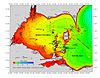
Lake Erie is the fourth largest lake of the five Great Lakes in North America and the eleventh-largest globally. It is the southernmost, shallowest, and smallest by volume of the Great Lakes and therefore also has the shortest average water residence time. At its deepest point Lake Erie is 210 feet deep.

Oliver Hazard Perry was an American naval commander, born in South Kingstown, Rhode Island. As the best-known and most prominent member of the Perry family naval dynasty, he was the son of Sarah Wallace Alexander and United States Navy Captain Christopher Raymond Perry, and older brother of Commodore Matthew C. Perry.
The Niagara River is a river that flows north from Lake Erie to Lake Ontario. It forms part of the border between the province of Ontario in Canada and the state of New York in the United States. There are differing theories as to the origin of the river's name. According to Iroquoian scholar Bruce Trigger, Niagara is derived from the name given to a branch of the locally residing native Neutral Confederacy, who are described as being called the Niagagarega people on several late-17th-century French maps of the area. According to George R. Stewart, it comes from the name of an Iroquois town called Ongniaahra, meaning "point of land cut in two".

Erie County is a county along the shore of Lake Erie in western New York State. As of the 2020 census, the population was 954,236. The county seat is Buffalo, which makes up about 28% of the county's population. Both the county and Lake Erie were named for the regional Iroquoian language-speaking Erie tribe of Native Americans, who lived in the area before 1654. They were later pushed out by the more powerful Iroquoian nations tribes.

Point Pelee National Park is a national park in Essex County in southwestern Ontario, Canada where it extends into Lake Erie. The word pelée is French for 'bald'. Point Pelee consists of a peninsula of land, mainly of marsh and woodland habitats, that tapers to a sharp point as it extends into Lake Erie. Middle Island, also part of Point Pelee National Park, was acquired in 2000 and is just north of the Canada–United States border in Lake Erie. Point Pelee is the southernmost point of mainland Canada, and is located on a foundation of glacial sand, silt and gravel that bites into Lake Erie. This spit of land is slightly more than seven kilometres long by 4.5 kilometres (2.8 mi) wide at its northern base. Established in 1918, Point Pelee was the first national park in Canada to be established for conservation. It was designated as a Ramsar site on 27 May 1987.

Erie is a city on the south shore of Lake Erie and the county seat of Erie County, Pennsylvania, United States.
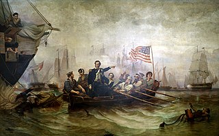
The Battle of Lake Erie, sometimes called the Battle of Put-in-Bay, was fought on 10 September 1813, on Lake Erie off the coast of Ohio during the War of 1812. Nine vessels of the United States Navy defeated and captured six vessels of the British Royal Navy. This ensured American control of the lake for the rest of the war, which in turn allowed the Americans to recover Detroit and win the Battle of the Thames to break the Indian confederation of Tecumseh. It was one of the biggest naval battles of the War of 1812.

The Regional Municipality of Niagara, also colloquially known as the Niagara Region or Region of Niagara, is a regional municipality comprising twelve municipalities of Southern Ontario, Canada. The regional seat is in Thorold. It is the southern end of the Golden Horseshoe, the largest megalopolis in Canada.

The Maumee River is a river running in the United States Midwest from northeastern Indiana into northwestern Ohio and Lake Erie. It is formed at the confluence of the St. Joseph and St. Marys rivers, where Fort Wayne, Indiana, has developed, and meanders northeastwardly for 137 miles (220 km) through an agricultural region of glacial moraines before flowing into the Maumee Bay of Lake Erie. The city of Toledo is located at the mouth of the Maumee. The Maumee was designated an Ohio State Scenic River on July 18, 1974. The Maumee watershed is Ohio’s breadbasket; it is two-thirds farmland, mostly corn and soybeans. It is the largest watershed of any of the rivers feeding the Great Lakes, and supplies five percent of Lake Erie’s water.

The Detroit River International Wildlife Refuge is the only international wildlife refuge in North America. Established in 2001 and managed jointly by the United States Fish and Wildlife Service and the Canadian Wildlife Service, it is located in a major metropolitan area. The Detroit River International Wildlife Refuge is one of over 540 National Wildlife Refuges managed by the U.S. Fish and Wildlife Service within the Department of the Interior. It occupies 7.88 square miles (20.41 km2) of scattered property but has drawn boundaries for further expansion.

Gibraltar Island is an island in Ohio, located within Lake Erie. This small 6.55-acre (0.026 km²) island is just offshore of South Bass Island. It is part of Put-in-Bay Township, Ottawa County, Ohio.

South Bass Island is a small island in western Lake Erie, and a part of Ottawa County, Ohio, United States. It is the southernmost of the three Bass Islands and located 3 miles (4.6 km) from the south shore of Lake Erie. It is the third largest island in the Lake Erie Islands, and is part of Put-in-Bay Township. In the bay of South Bass is Gibraltar Island, home to the Ohio State University's Stone Laboratory.

West Sister Island is an island of the U.S. state of Ohio located in the Western Basin of Lake Erie. The 82 acres (33 ha) island, jointly owned by the United States Coast Guard and the U.S. Fish and Wildlife Service, is Ohio's only designated Wilderness Area, the West Sister Island National Wildlife Refuge.

Amherstburg Royal Naval Dockyard was a Provincial Marine and then a Royal Navy yard from 1796 to 1813 in Amherstburg, Ontario, situated on the Detroit River. The yard comprised blockhouses, storehouses, magazine, wood yard and wharf. The yard was established in 1796 to support the Upper Canada Provincial Marine after Great Britain ceded a pre-existing shipyard on the Detroit River to the United States. Amherstburg Royal Naval Dockyard constructed four warships for the Lake Erie detachment of the Provincial Marine before and during the War of 1812. In 1813 the dockyard was abandoned and destroyed when the British retreated and never reopened. In 1928, the site was designated a National Historic Site of Canada.

The geography of New York state varies widely. Most of New York is dominated by farms, forests, rivers, mountains, and lakes. New York's Adirondack Park is larger than any U.S. National Park in the contiguous United States. Niagara Falls, on the Niagara River as it flows from Lake Erie to Lake Ontario, is a popular attraction. The Hudson River begins near Lake Tear of the Clouds and flows south through the eastern part of the state without draining lakes George or Champlain. Lake George empties at its north end into Lake Champlain, whose northern end extends into Canada, where it drains into the Richelieu River and then the St. Lawrence. Four of New York City's five boroughs are on the three islands at the mouth of the Hudson River: Manhattan Island, Staten Island, and Brooklyn and Queens on Long Island.

The Great Lakes Basin consists of the Great Lakes and the surrounding lands of the states of Illinois, Indiana, Michigan, Minnesota, New York, Ohio, Pennsylvania, and Wisconsin in the United States, and the province of Ontario in Canada, whose direct surface runoff and watersheds form a large drainage basin that feeds into the lakes. It is generally considered to also include a small area around and beyond Wolfe Island, Ontario, at the east end of Lake Ontario, which does not directly drain into the Great Lakes, but into the Saint Lawrence River.

The Vacationland region of Ohio - billed as such for being known primarily as a major summertime tourist destination - is the area that is generally considered to be in the north central part of the state, and along the western half of the Lake Erie shoreline, specifically the counties of Erie, Huron, Ottawa, and Sandusky.

Catawba Island State Park is a ten-acre (4.0 ha) public recreation area located on Lake Erie, six miles northeast of Port Clinton, Ohio. Boating, fishing and picnicking are the major activities of the park. The state park, along with the other units in Ohio's Lake Erie state parks group, was established in the early 1950s.