Hemlock, Ohio | |
---|---|
Coordinates: 39°35′26″N82°09′16″W / 39.59056°N 82.15444°W | |
Country | United States |
State | Ohio |
County | Perry |
Hemlock | July 15, 1872 |
Government | |
• Type | Mayor council government |
• Mayor | James R. Knippa |
Area | |
• Total | 0.37 sq mi (0.97 km2) |
• Land | 0.37 sq mi (0.96 km2) |
• Water | 0.00 sq mi (0.01 km2) |
Elevation | 856 ft (261 m) |
Population (2020) | |
• Total | 142 |
• Density | 381.72/sq mi (147.28/km2) |
Time zone | UTC-5 (Eastern (EST)) |
• Summer (DST) | UTC-4 (EDT) |
ZIP code | Original 43743. Current 43730 |
Area code | 740 |
FIPS code | 39-34888 [3] |
GNIS feature ID | 2398486 [2] |
Hemlock is a village in Perry County, Ohio, United States. The population was 142 at the 2020 census. The village was originally settled as Coaldale on June 15, 1869, and established as Hemlock on July 15, 1872. A post office was in operation until October 3, 1986.
Originally settled as Coaldale on June 15, 1869, then established as Hemlock on July 15, 1872. [4] The Hemlock post office was in operation until October 3, 1986. The village was named for a grove of hemlock trees near the original town site. [5]
According to the United States Census Bureau, the village has a total area of 0.37 square miles (0.96 km2), all land. [6]
Census | Pop. | Note | %± |
---|---|---|---|
1900 | 581 | — | |
1910 | 452 | −22.2% | |
1920 | 497 | 10.0% | |
1930 | 282 | −43.3% | |
1940 | 353 | 25.2% | |
1950 | 253 | −28.3% | |
1960 | 227 | −10.3% | |
1970 | 199 | −12.3% | |
1980 | 197 | −1.0% | |
1990 | 203 | 3.0% | |
2000 | 142 | −30.0% | |
2010 | 155 | 9.2% | |
2020 | 142 | −8.4% | |
U.S. Decennial Census [7] |
As of the census [8] of 2010, there were 155 people, 56 households, and 46 families living in the village. The population density was 418.9 inhabitants per square mile (161.7/km2). There were 71 housing units at an average density of 191.9 per square mile (74.1/km2). The racial makeup of the village was 100.0% White.
There were 56 households, of which 37.5% had children under the age of 18 living with them, 64.3% were married couples living together, 12.5% had a female householder with no husband present, 5.4% had a male householder with no wife present, and 17.9% were non-families. 17.9% of all households were made up of individuals, and 5.4% had someone living alone who was 65 years of age or older. The average household size was 2.77 and the average family size was 3.00.
The median age in the village was 39.4 years. 25.2% of residents were under the age of 18; 9.7% were between the ages of 18 and 24; 22.6% were from 25 to 44; 30.9% were from 45 to 64; and 11.6% were 65 years of age or older. The gender makeup of the village was 49.7% male and 50.3% female.
As of the census [3] of 2000, there were 142 people, 48 households, and 39 families living in the village. The population density was 374.2 inhabitants per square mile (144.5/km2). There were 58 housing units at an average density of 152.9 per square mile (59.0/km2). The racial makeup of the village was 95.07% White, 2.11% Asian, and 2.82% from two or more races. Hispanic or Latino of any race were 2.11% of the population.
There were 48 households, out of which 45.8% had children under the age of 18 living with them, 66.7% were married couples living together, 14.6% had a female householder with no husband present, and 16.7% were non-families. 16.7% of all households were made up of individuals, and 10.4% had someone living alone who was 65 years of age or older. The average household size was 2.96 and the average family size was 3.30.
In the village, the population was spread out, with 33.1% under the age of 18, 8.5% from 18 to 24, 33.1% from 25 to 44, 12.7% from 45 to 64, and 12.7% who were 65 years of age or older. The median age was 32 years. For every 100 females there were 94.5 males. For every 100 females age 18 and over, there were 82.7 males.
The median income for a household in the village was $26,250, and the median income for a family was $28,333. Males had a median income of $28,750 versus $17,917 for females. The per capita income for the village was $7,701. There were 26.3% of families and 24.3% of the population living below the poverty line, including 29.4% of under eighteens and 22.2% of those over 64.
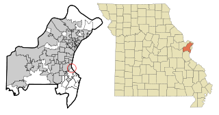
Country Life Acres is a village in St. Louis County, Missouri, United States. The population was 72 at the 2020 census.
Mackenzie is an unincorporated community in St. Louis County, Missouri, United States. The population was 134 at the 2010 census.
Westwood is a village in west St. Louis County, Missouri, United States. The population was 316 at the 2020 census.
Wilbur Park is a village in St. Louis County, Missouri, United States. The population was 439 at the 2020 census.
Warsaw is a village in Coshocton County, Ohio, United States, along the Walhonding River. The population was 624 at the 2020 census.
Brice is a village in Franklin County, Ohio, United States, on the southeast side of the Columbus metropolitan area. The population was 93 at the 2020 census.
Addyston is a village in Miami Township, Hamilton County, Ohio, United States. Located along the Ohio River, it is a western suburb of the neighboring city of Cincinnati. The population was 927 at the 2020 census.
Evendale is a village in Hamilton County, Ohio, United States, within the Cincinnati metropolitan area. The population was 2,669 at the 2020 census.
Sheffield is a village in Lorain County, Ohio, United States, along the Black River. The population was 4,135 at the 2020 census. It is part of the Cleveland metropolitan area.
Burbank is a village in Wayne County, Ohio, United States, along Killbuck Creek. The population was 296 at the 2020 census.
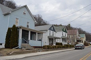
Coaldale is a borough in Bedford County, Pennsylvania, United States. As of the 2020 census the borough population was 126. The post office serving Coaldale is called Six Mile Run.
West Hemlock Township is a township in Montour County, Pennsylvania, United States.
Triumph Township is a township in Warren County, Pennsylvania, United States. The population was 276 at the 2020 census, down from 316 at the 2010 census.
Windsor Heights is a village in Brooke County, West Virginia, United States. It is part of the Wheeling, West Virginia Metropolitan Statistical Area. The population was 423 at the 2010 census. Grace Davis was the mayor as of June 2017.
Friesland is a village in Columbia County, Wisconsin, United States. The population was 320 at the 2020 census. It is part of the Madison Metropolitan Statistical Area, and was named after Friesland, one of the twelve provinces of the Netherlands.
Browntown is a village in Green County, Wisconsin, United States. The population was 280 at the 2010 census.
Gratiot is a village in Licking and Muskingum counties in the U.S. state of Ohio. The population was 215 at the 2020 census.
Verona is a village in Montgomery and Preble counties in the U.S. state of Ohio. The population was 403 at the 2020 census. It is part of the Dayton Metropolitan Statistical Area.
Vernon is a village in Oneida County, New York, United States. The population was 1,172 at the 2010 census.
Lowell is a village in Dodge County, Wisconsin, United States, along the Beaver Dam River. The population was 340 at the 2010 census. The village is located within the Town of Lowell.