
Pine Flat Dam is a concrete gravity dam on the Kings River in the Central Valley of Fresno County, California United States. Situated about 28 miles (45 km) east of Fresno, the dam is 440 feet (130 m) high and impounds Pine Flat Lake, one of the largest reservoirs in California, in the foothills of the Sierra Nevada just outside the boundary of Kings Canyon National Park. The dam's primary purpose is flood control, with irrigation, hydroelectric power generation and recreation secondary in importance.

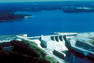
Dworshak Dam is a concrete gravity dam in the western United States, on the North Fork Clearwater River in Clearwater County, Idaho. The dam is located approximately four miles (6 km) northwest of Orofino and impounds the Dworshak Reservoir for flood control and hydroelectricity generation. With a height of 717 feet (219 m), Dworshak is the third tallest dam in the United States and the tallest straight-axis concrete dam in the Western Hemisphere. Lacking fish ladders, Dworshak Dam blocks fish passage and completely extirpated anadromous fish migration into the upper reaches of the North Fork Clearwater River and its tributaries in Idaho. Construction of the dam by the U.S. Army Corps of Engineers (USACE) began in 1966 and was completed in 1973.
Stockton Lake is a reservoir located in southeastern Cedar County, northeastern Dade County, and southwestern Polk County, Missouri. The lake is 'V' shaped, and covers 39 square miles (100 km2), with 298 miles (480 km) of shoreline. It has three marinas, and 10 public-use areas. It has a "non-development policy," and is surrounded by unspoiled, tree-covered hills. Its banks are owned and operated by the Army Corps of Engineers.
Smithville Lake is a 7,190-acre (29 km2) reservoir on the Little Platte branch of the Platte River in Clay County, Missouri near Smithville. It provides the water supply for Smithville, Missouri and Plattsburg, Missouri. Kansas City, Missouri has reserved a portion for its water supply.
