The Ohio River is a 981-mile (1,579 km) long river in the United States. It is located at the boundary of the Midwestern and Southern United States, flowing in a southwesterly direction from western Pennsylvania to its mouth on the Mississippi River at the southern tip of Illinois. It is the third largest river by discharge volume in the United States and the largest tributary by volume of the north-south flowing Mississippi River, which divides the eastern from western United States. It is also the 6th oldest river on the North American continent. The river flows through or along the border of six states, and its drainage basin includes parts of 14 states. Through its largest tributary, the Tennessee River, the basin includes several states of the southeastern U.S. It is the source of drinking water for five million people.

The Monongahela River, sometimes referred to locally as the Mon, is a 130-mile-long (210 km) river on the Allegheny Plateau in north-central West Virginia and Southwestern Pennsylvania. The river flows from the confluence of its west and east forks in north-central West Virginia northeasterly into southwestern Pennsylvania, then northerly to Pittsburgh and its confluence with the Allegheny River to form the Ohio River. The river includes a series of locks and dams that makes it navigable.

The Allegheny Mountain Range, informally the Alleghenies, is part of the vast Appalachian Mountain Range of the Eastern United States and Canada and posed a significant barrier to land travel in less developed eras. The Allegheny Mountains have a northeast–southwest orientation, running for about 300 miles (480 km) from north-central Pennsylvania, southward through western Maryland and eastern West Virginia.

The Little Kanawha River is a tributary of the Ohio River, 169 mi (269 km) long, in western West Virginia in the United States. Via the Ohio, it is part of the watershed of the Mississippi River, draining an area of 2,320 mi2 (6,009 km2) on the unglaciated portion of the Allegheny Plateau. It served as an important commercial water route in the early history of West Virginia, particularly in the logging and petroleum industries.

The Cheat River is a 78.3-mile-long (126.0 km) tributary of the Monongahela River in eastern West Virginia and southwestern Pennsylvania in the United States. Via the Ohio River, the Cheat and Monongahela are part of the Mississippi River watershed. Owing to the ruggedness of the surrounding Allegheny Mountains, the Cheat remains largely remote with few settlements or developments along its banks. Its headwaters are in the Cheat-Potomac Ranger District of the Monongahela National Forest.
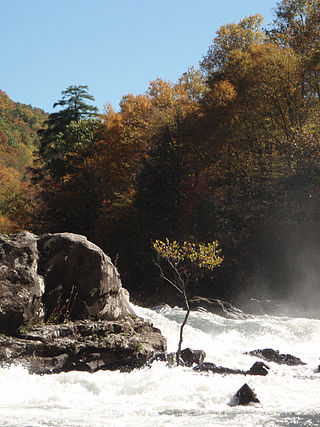
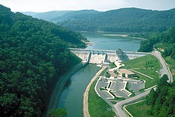
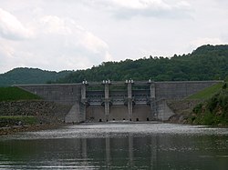
The Gauley River is a 105-mile-long (169 km) river in West Virginia. It merges with the New River to form the Kanawha River, a tributary of the Ohio River. The river features numerous recreational whitewater areas, including those in Gauley River National Recreation Area downstream of the Summersville Dam.

The West Fork River is a principal tributary of the Monongahela River, 103-mile (166 km) long, in north-central West Virginia, United States. Via the Monongahela and Ohio Rivers, it is part of the watershed of the Mississippi River, draining an area of 881 square miles (2,284 km²) on the unglaciated portion of the Allegheny Plateau.

The Tygart Valley River — also known as the Tygart River — is a principal tributary of the Monongahela River, approximately 135 miles (217 km) long, in east-central West Virginia in the United States. Via the Monongahela and Ohio rivers, it is part of the watershed of the Mississippi River, draining an area of 1,329 square miles (3,440 km2) in the Allegheny Mountains and the unglaciated portion of the Allegheny Plateau.
Transport in the U.S. state of West Virginia is handled by the West Virginia Department of Transportation (WVDOT) which employs more than 6,000 in West Virginia.

Opekiska Lock and Dam is a navigational lock and gated dam on the Monongahela River at Lowsville, West Virginia. It is part of a series of dams that canalizes the Monongahela to a depth of at least 9 feet (2.7 m) for its entire length from Fairmont, West Virginia to Pittsburgh, Pennsylvania. It is maintained by the U.S. Army Corps of Engineers' Pittsburgh District.
Seneca Dam was the last in a series of dams proposed on the Potomac River in the area of the Great Falls of the Potomac. Apart from small-scale dams intended to divert water for municipal use in the District of Columbia and into the Chesapeake and Ohio Canal, no version of any scheme was ever built. In most cases the proposed reservoir would have extended upriver to Harpers Ferry, West Virginia. The project was part of a program of as many as sixteen major dams in the Potomac watershed, most of which were never built.
The Potomac River basin reservoir projects were U.S. Army Corps of Engineers programs that sought to regulate the flow of the Potomac River to control flooding, to assure a reliable water supply for Washington, D.C., and to provide recreational opportunities. Beginning in 1921 the Corps studied a variety of proposals for an ambitious program of dam construction on the Potomac and its tributaries, which proposed as many as sixteen major dam and reservoir projects. The most ambitious proposals would have created a nearly continuous chain of reservoirs from tidewater to Cumberland, Maryland. The 1938 program was focused on flood control, on the heels of a major flood in 1936. The reformulated 1963 program focused on water supply and quality, mitigating upstream pollution from sewage and coal mine waste.