
The Cheyenne River, also written Chyone, referring to the Cheyenne people who once lived there, is a tributary of the Missouri River in the U.S. states of Wyoming and South Dakota. It is approximately 295 miles (475 km) long and drains an area of 24,240 square miles (62,800 km2). About 60% of the drainage basin is in South Dakota and almost all of the remainder is in Wyoming.

Lake Sharpe is a large reservoir impounded by Big Bend Dam on the Missouri River in central South Dakota, United States. The lake has an area of 56,884 acres (230.20 km2) and a maximum depth of 78 ft (24 m). Lake Sharpe is approximately 80 mi (130 km) long, with a shoreline of 200 mi (320 km). Lake Sharpe is the 54th largest reservoir in the United States. The lake starts near Ft. Thompson and stretches upstream to Oahe Dam, near Pierre. The lake is located within the following counties: Buffalo, Lyman, Hyde, Hughes, and Stanley. The Big Bend of the Missouri is about 7 miles (11 km) north of the dam.

The Oahe Dam is a large earthen dam on the Missouri River, just north of Pierre, South Dakota, United States. The dam creates Lake Oahe, the fourth-largest man-made reservoir in the United States. The reservoir stretches 231 miles (372 km) up the course of the Missouri to Bismarck, North Dakota. The dam's power plant provides electricity for much of the north-central United States. It is named for the Oahe Indian Mission established among the Lakota Sioux in 1874.

Lake Oahe is a large reservoir behind Oahe Dam on the Missouri River; it begins in central South Dakota and continues north into North Dakota in the United States. The lake has an area of 370,000 acres (1,500 km2) and a maximum depth of 205 ft (62 m). By volume, it is the fourth-largest reservoir in the US. Lake Oahe has a length of approximately 231 mi (372 km) and has a shoreline of 2,250 mi (3,620 km). 51 recreation areas are located along Lake Oahe, and 1.5 million people visit the reservoir every year. The lake is named for the 1874 Oahe Indian Mission.
Pactola Lake is the largest and deepest reservoir in the Black Hills, located 15 miles west of Rapid City, South Dakota, United States. Constructed in 1952, the dam and waters are managed by the Bureau of Reclamation, with the surrounding land managed by the US Forest Service as part of Black Hills National Forest, which operates a visitor center located on the south side of the dam. Facilities include campgrounds, hiking trails, picnic areas, and a beach.

Pine Flat Dam is a concrete gravity dam on the Kings River in the Central Valley of Fresno County, California United States. Situated about 28 miles (45 km) east of Fresno, the dam is 440 feet (130 m) high and impounds Pine Flat Lake, one of the largest reservoirs in California, in the foothills of the Sierra Nevada just outside the boundary of Kings Canyon National Park. The dam's primary purpose is flood control, with irrigation, hydroelectric power generation and recreation secondary in importance.

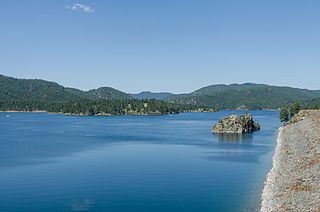
Angostura Reservoir is a reservoir on the Cheyenne River in Fall River County, South Dakota, United States. It was created after the construction of Angostura Dam in 1949 for irrigation by the U.S. Bureau of Reclamation. "Angostura" means "narrows" in Spanish.

Pactola Dam is an embankment dam on Rapid Creek in Pennington County, South Dakota, about 10 miles (16 km) west of Rapid City. The dam was completed in 1956 by the U.S. Bureau of Reclamation to provide flood control, water supply and recreation. Along with the nearby Deerfield Dam, it is part of the Rapid Valley Unit of the Pick-Sloan Missouri Basin Program. U.S. Route 385 runs along the crest of the dam. The dam forms Pactola Lake, which at over 1,200 acres (490 ha) is the largest and deepest body of water in the Black Hills.
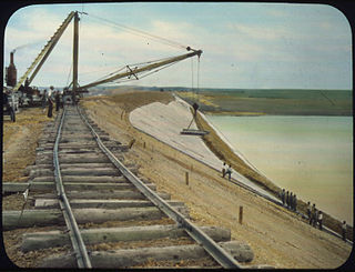
The Belle Fourche Dam, also known as Orman Dam, is a dam on Owl Creek in Butte County, South Dakota, USA, approximately eight miles east of Belle Fourche, South Dakota, along U.S. Route 212. Its construction created the Belle Fourche Reservoir, the Belle Fourche National Wildlife Refuge, and the Rocky Point Recreation Area.

Bowman-Haley Dam is an embankment dam located in Bowman County, North Dakota, in the southwestern part of the state. The dam is just over 2 miles north of the South Dakota border.
The Standing Rock Rural Water System (RWS) is a $30 million water system funded by the American Recovery and Reinvestment Act in 2009 for about 10,000 residents of the Standing Rock Sioux reservation in North Dakota. The RWS includes the Standing Rock Water Treatment and the "Indian Memorial Intake Pump Station, a raw water pipeline, two transmission pipelines and Kline Butte Storage Reservoir." The main regulation reservoir of the Standing Rock Rural Water System is the $3.6 million Kline Butte Storage Reservoir, located southwest of Kenel, South Dakota, which consists of a 5 million gallon ground storage reservoir. Currently, the intake valve for the water system is "located in a shallow part of the Missouri River near Fort Yates, North Dakota, roughly 20 miles from the planned river crossing of the controversial Dakota Access Pipeline also known as the Bakken pipeline. The Bakken oil pipeline Dakota line is to be "buried 92 feet (28 m) below the riverbed in hard clay." A new valve came online in 2016 in Mobridge, South Dakota which is seventy miles south of the proposed Bakken Pipeline Missouri River crossing. This Mobridge intake valve is intended to service the entire Standing Rock Sioux reservation.

